Archive for January, 2013

Some background on the politics of airports in Sydney – the airport debate was shaped dramatically in 1995 following the opening of a third runway in Sydney’s Kingsford-Smith airport. While this upgrade deferred the need for a second airport for some time, it also angered many locals due to the increase in aircraft noise that it brought with it, resulting in the formation of the No Aircraft Noise Party. This party received 39% of the vote in Marrickville and 36% in Port Jackson on a 2 party preferred basis (Source: Psephos), both heavily affected by increased aircraft noise. In 2003, the Labor Party changed its platform to oppose a second airport at Badgerys Creek (the irony being that it had been Hawke Labor Government that obtained the land in the first place in 1986), and the Coalition followed soon after.

In the 2012, the debate over a Second Sydney Airport seemed to be whether or not to build one. Those against an airport included the NSW Premier, Barry O’Farrell, and the federal National Party leader, Warren Truss, who was also the Shadow Transport Minister. Local MPs and councils in the Western Sydney area (of both parties, but mostly from the area’s dominant Labor Party), where a second airport would be built, also seemed almost universally opposed to a second airport. Meanwhile, the Federal Transport Minister, Anthony Albanese, and Federal Shadow Treasurer, Joe Hockey, both supported a second airport,but appeared to rule out Badgerys Creek, leaving Wilton as the remaining preferred option.

(Source: Author and Google Maps)

Click on image for higher resolution. (Source: Author and Google Maps)

It began with the release of a report last year entitled the Joint Study on Aviation Capacity for the Sydney Region. The knee jerk response was measured at best, with politicians continuing to state their opposition to Badgerys Creek, despite the joint study finding that it was still the best location. Anthony Albanese, restricted by Labor Party policy, announced a second study into Wilton, the second best site identified by the joint study. Jake Saulwick’s opinion piece in the Herald suggests that Mr Albanese actually prefers Badgerys Creek, and the Wilton study is designed to demonstrate that Wilton is not suitable (primarily because it is too far from either Western Sydney or Sydney CBD, not very flat, and prone to fog). At this point, a push can be made to change the Labor Party’s platform to remove the ban on Badgerys Creek.

Meanwhile, commentators began to point out that an airport in Western Sydney would bring jobs and economic development, not just aircraft noise, and this is something that Western Sydney desperately needs in order to stem the daily mass migration from Western Sydney into the CBD because the region has fewer jobs than it has workers. This appears to have been the turning point in the debate, and by the start of 2013 politicians who had previously ruled out Badgerys Creek, and even ones who ruled out a second airport entirely, were now calling for Badgerys Creek to be put on the table as an option. Some even openly began calling for Badgerys Creek to be the site of a second airport.

The case for a second airport was also boosted when it was announced that the decision to host the 2014 G20 meeting in Brisbane rather than Sydney was driven partly by a lack of the required space in which to park 40 jumbo jets for the duration of the summit. The take home lesson from this was clear – Sydney Airport isn’t just close to reaching capacity, by some measures it already has reached capacity.

What appears to have happened is that politicians have privately come to the realisation that Sydney needs to start planning for a second airport, and that this second airport will need to happen in Badgerys Creek. Additionally, this is something that is going to affect whichever party is in government at the time, so opposing it for political gain will only come back to hurt that party in the future once they are in opposition.

While it remains an unpopular position, there has been a clear movement towards supporting Badgerys Creek in the last 12 months. The recent views of key individuals in this debate are included below.

Opposes a Second Airport

Few actually flat out oppose a second airport in the Sydney basin. Those that do tend to have self interest in mind (Sydney Airport Chairman Max Moore-Wilton) or know that as it is an issue for the federal government they can champion a popular position without having to make that decision themselves (Barry O’Farrell).

Barry O'Farrell, NSW Premier (Image: NSW Parliament)

Barry O’Farrell, NSW Premier (Image: NSW Parliament)

“The NSW government believes no other part of Sydney should be contaminated by the sort of noise that comes with an airport. The most sensible option is to build a fast-rail link to the federal capital and use Canberra Airport for additional capacity for flights.”Barry O’Farrell (6 April 2012)

Max Moore-Wilton, Chairman of Sydney Airport Corporation (Image: Infrastructure NSW)

Max Moore-Wilton, Chairman of Sydney Airport Corporation (Image: Infrastructure NSW)

“Mr Albanese has rejected the nine [of ten joint study recommendations] and focused on the one. You might well say it is not a level playing field on this issue. One of their recommendations was that the cap be increased by five movements an hour [from eighty to eighty-five] – that recommendation has been rejected by Mr Albanese.” Max Moore-Wilton (17 May 2012)

Opposes Badgerys Creek

Most of the opposition now comes not towards a second airport, but to Badgerys Creek specifically as a location. The potential for local opposition has only grown in recent decades as the population of Western Sydney has continued to grow. The case for Badgerys Creek is not helped by the presence of 2 members of Federal Cabinet (Chris Bowen and David Bradbury) being MPs from Western Sydney, nor from the state opposition leader (John Robertson) also being an MP from Western Sydney. In Mr Bowen’s case, he has remained tight lipped on Badgerys Creek ever since the 2007 election put his Labor Party into government, and you have to go back to 2007 to get an on the record comment from him on the matter.

John Robertson, NSW Opposition Leader (Image: NSW Parliament)

John Robertson, NSW Opposition Leader and State MP for Blacktown (Image: NSW Parliament)

“State Opposition Leader John Robertson says while he has ruled out Badgerys Creek, he is waiting for a briefing on the report before cementing Labor’s position.”ABC News (23 April 2012)

Chris Bowen, Federal Minister for Immigration and Federal MP for McMahon (Image: Department of Immigration)

Chris Bowen, Federal Minister for Immigration and Federal MP for McMahon (Image: Department of Immigration)

 “A Rudd Labor government will not build an airport at Badgerys Creek.”Chris Bowen (19 September 2007)

David Bradbury, Federal Assistant Treasurer and Federal MP for Lindsay (Image: Australian Consumer Law)

David Bradbury, Federal Assistant Treasurer and Federal MP for Lindsay (Image: Australian Consumer Law)

“I will continue to be a strong advocate for our community and for as long as I represent the people of Lindsay an airport will not be built in Badgerys Creek.”David Bradbury (4 April 2012)

Open to Badgerys Creek

This category involves reading between the lines at times. In Anthony Albanese’s case, in particular, he is on the record as opposing Badgerys Creek, supporting Wilton instead. But his actions, or rather lack thereof, suggest that he actually prefers Badgerys Creek. It therefore seems most logical to place him into this category. In Warren Truss’ case, he had previously ruled out a second airport entirely, whereas he now appears to have backtracked to just ruling out Badgery Creek in the context of the next election, suggesting that he also is reconsidering his position.

Anthony Albanese, Federal Transport Minister (Image: Department of Transport and Infrastructure)

Anthony Albanese, Federal Transport Minister (Image: Department of Transport and Infrastructure)

“You get the sense [backtracking on Simon Crean’s 2003 vow that Labor would not build an airport at Badgerys Creek] is what Albanese wants to do.” Jake Saulwick (17 November 2012)

Joe Hockey

Joe Hockey, Federal Shadow Treasurer (Image: http://www.joehockey.com)

“The suggestion that Badgerys Creek is going to disadvantage western Sydney is just rubbish. If you have a second airport in the Sydney basin there will be a massive financial and employment boost…Badgerys Creek has been foreshadowed for 30 years and the Commonwealth owns the land. There should be no barrier to Badgerys Creek.” – Joe Hockey (1 January 2013)

Warren Truss, Federal Deputy Leader of the Opposition and Federal Shadow Transport Minister (Image: Australian Parliament)

Warren Truss, Federal Shadow Transport Minister (Image: Australian Parliament)

“I know the problems with all of the sites, but I know why Badgerys Creek was chosen in the first place, and I thought it was very interesting the [recent state and federal inquiry] basically put it right back on the table. But both sides of politics have ruled it out, so that is where it is at the moment. We’ve ruled it out, and we will rule it out in the context of the next election as well, and Labor has ruled it out as well.

I think it would be helpful if there could be some kind of bipartisan agreement about what is the best site, taking into account what the options actually are, because it will be many years before the project starts and many years to build, so it is highly likely it will cross political eras.” – Warren Truss (12 December 2012)

Laurie Ferguson, Federal MP for Werriwa (Image: Australian Parliament)

Laurie Ferguson, Federal MP for Werriwa (Image: Australian Parliament)

“Werriwa MP Laurie Ferguson said he needed more time to go through the report before deciding his stance but said his decision would be greatly influenced by Campbelltown Council.” – Laurie Ferguson (7 March 2012)

Supports Badgerys Creek

Up until Nathan Rees came out in support of Badgerys Creek, it was virtually impossible to find any current Western Sydney MPs willing to state their support of Badgerys Creek on the record. Former politicians, those who stand to directly benefit, and independent experts have tended to be the only ones championing the site.

Alan Joyce, Qantas CEO (Image: Qantas)

Alan Joyce, Qantas CEO (Image: Qantas)

“We also agree that Badgerys Creek remains the best site. Since the late 1980s, this land has been reserved for a new airport…The arguments for and against Badgerys Creek – and every other contender – are familiar. We are wasting our energy going over old ground.”Alan Joyce (23 April 2012)

Nick Greiner, Infrastructure NSW Chairman and former NSW Premier (Image: Infrastructure NSW)

Nick Greiner, Infrastructure NSW Chairman and former NSW Premier (Image: Infrastructure NSW)

“The average person in western Sydney, I think, rationally ought to be overwhelmingly in favour of an airport at Badgerys Creek.” – Nick Greiner (12 October 2012)

Nathan Rees, Former NSW Premier and current State MP for Toongabbie (Image: NSW Parliament)

Nathan Rees, State MP for Toongabbie and former NSW Premier  (Image: NSW Parliament)

“in policy terms [Badgerys Creek was by far the best site for the airport but] politically this is extremely difficult”. – Nathan Rees (7 January 2013)

David Borger, Western Sydney Director for the Sydney Business Chamber and former NSW Roads Minister (Image: Sydney Business Chamber)

David Borger, Western Sydney Director for the Sydney Business Chamber and former NSW Roads Minister (Image: Sydney Business Chamber)

“Borger…is an enthusiastic backer of a Badgerys Creek airport.”Sydney Morning Herald (21 December 2012)

A recent piece on Channel Seven’s Today Tonight program discusses transport usage across a number of Australian cities over the last 35 years, and finds that Sydneysiders have the highest public transport use of any Australian city. (This isn’t really new information, given that transport is one of the questions asked in each 5 year census.) The video of the story is included at the end of this post.

Public transport mode share vs population density for various Australian cities. Click on image for higher resolution. (Source: Charting Transport via The Urbanist.)

Public transport mode share vs population density for various Australian cities. Click on image for higher resolution. (Source: Charting Transport via The Urbanist.)

The report correctly points out that this fact would probably surprise many Sydney commuters, as would the assertion made by Dr Lucy Groenhart, an RMIT academic and author of the report, that Sydney is “built around a strong heavy rail network” and has buses which “are better co-ordinated than in other cities”. Dr Groenhart appears to be comparing Sydney to Melbourne, where one major flaw in the network design was separate train and tram networks that competed rather than complemented each other (so it’s quite common to see a train and tram line running in parallel). Conversely, in Sydney the network has been designed around the rail network, with feeder buses that link commuters from their home to the nearest station or transport them between stations on different lines. This expands the catchment of the transport network considerably.

Countering this view is Kerryn Wilmot, Research Principal for the Institute for Sustainable Futures at UTS, who points out that Sydney lacks integrated fares. It’s true that while Sydney has an integrated network, it lacks an integrated fares system. That means that users are penalised if they make a transfer (unless it is train to train), which prevents an integrated network from working most efficiently. Having a myMulti ticket does get around this problem, but these are currently only available as periodicals (there is a daily ticket, though very expensive at $21) and are city-centric, meaning that if you only intend to travel within one of the outer zones then you must also pay for the inner zones even if you aren’t heading into the CBD or inner city. However, Ms Wilmot’s claim that “you can’t get a yearly that just allows you to become a public transport user to do all of the stuff you want to do during the week” would appear to be incorrect, as you can get a yearly myMulti ticket which would allow you to do that (unless you just wanted one for one of the outer zones only, which as mentioned earlier is not currently allowed).

Towards the end of the piece it makes the point that taking the toll roads from Northwest Sydney only saves one minute of travel time, yet costs $12 in tolls. What it does not point out is that most of this trip is along the M2, which is being widened and where the associated road works have virtually eliminated the travel time savings until the construction has finished (which just so happens to be some time early this year). This is just sloppy journalism, but while that’s normally the norm for Today Tonight, this time it appears to be the exception. That, and the bit where the reporter is walking on the bike path, which is just as illegal as bikes on footpaths not designated as shared paths.

Dr Groenhart concludes that “the government’s priorities are not with sustainable transport so they are with roads”. She doesn’t state which government she is referring to, and given that Today Tonight did a Sydney and Melbourne version of this story, it is possible that she was referring to the Victorian government. This would make sense, given the Victorian government has made a road tunnel under the CBD it’s top priority, with a smaller CBD rail tunnel being the next most important transport project. Compare that to NSW, where the top project is the Northwest Rail Link (a public transport project), and the next most important projects are WestConnex (a road) and a Second Harbour Crossing (another public transport project).

Southern Sydney Freight Line opens

Posted: January 22, 2013 in Transport
Tags: ,

3 years behind schedule and $700m over budget, the Southern Sydney Freight Line was opened yesterday. This new line will separate freight trains from passenger trains between Sefton and Macarthur, which until now had required an 8 hour curfew between the morning and afternoon peak hours that prevented freight trains from using that section of the line.

Sydney previously had an exclusive freight rail line only between Port Botany through to Sefton (red in the diagram below), with freight trains having to share track with passenger trains on the Western, Northern, South, and Illawarra Lines. There was also a freight line that connected Dulwich Hill to Darling Harbour, but the conversion of Sydney Harbour from a working port to a cultural centre has allowed that line to be used for light rail.

Moorebank Intermodal

The Southern Sydney Freight Line is shown in green. Click on image for higher resolution. (Source: Department of Infrastructure and Transport)

The South Sydney Freight Line (blue in the diagram above) will now allow trains to continue South unimpeded by passenger trains. It will later be supplemented by the Northern Sydney Freight Line (orange in the diagram above), which will allow freight trains to cross the entirety of metropolitan Sydney without disrupting passenger services, helping to take more trucks off the road.

Media reports

Billion-dollar freight rail line opens in Sydney, ABC News

‘We wanted to make sure we got it right’: new rail line opens … three years late, Sydney Morning Herald

Freight train bottleneck solution finally lands, with $1b price tag, Sydney Morning Herald

New freight link boosts speed: govt, Daily Telegraph

One of the first posts I made on this blog in mid 2011 was about real time location services for public transport. At the time, this was limited to an SMS service where you send a message with a bus stop number and receive a response with all buses set to arrive there in the next half hour, achieved by installing GPS devices on buses to track where they are at any given time. There was also the 131500.info trip planner, but it did not provide real time data nor was it the most user friendly system out there. Mobile apps like TripView did provide a better user interface, but did not provide multi modal functionality (so if you had to catch a bus and train then you needed to do 2 separate searches). Meanwhile, the easy to use Google Transit function on Google Maps was limited to trams and the monorail in Sydney.

At the time, I lamented that there was not some more user friendly, perhaps more graphical form of providing this service, and one that provided the actual real time location of your bus/train/ferry/tram rather than just what’s on the timetable. There was little reason why either wasn’t possible at the time, in fact the former had already been achieved by Fink Labs before being shut down by the Transport Department (see image below).

Fink labs bus app

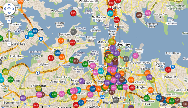
A discontinued real time bus location app. (Source: Fink Labs.)

Thing have changed significantly since then. Google Transit expanded to all modes of transport, while real time data (currently only for for government buses, but hopefully set to be expanded to all buses next year) was introduced to transport apps. So here is a summary of some of the major transport services: 131500, Google Transit, TripView, and TripGo.

Note: One of the mobile apps (Arrivo Sydney) that recently added real time information is Android only, and as an iPhone user I was unable to try it out.

131500

Pros: multi-modal, offers a call center service

Cons: Interface could be easier to use, no real time data

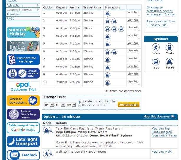
This is the official government transport information service. It was great when it first came out years ago, but has seen little improvement since. In almost every case, you’re better off going with Google Transit. Google’s service is easier to use, has a better display, and everything that Google is missing is also missing from 131500. The one exception is the phone service for those luddites out there, where someone at the call center will let you know the details you need.

Strangely enough, despite this being the government service, it lacks real time data for buses.

131500

Google Transit

Pros: easy to use interface, good for people unfamiliar with transport network, multi-modal

Cons: no real time data

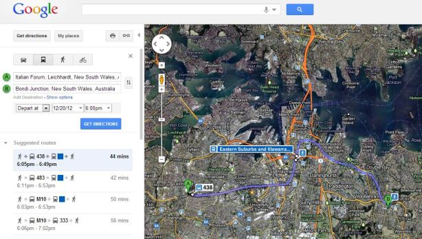
All bus, train, ferry, and light rail timetable data in was incorporated in July of 2012. It provides multi-modal information, so you do not have to do a separate search for a bus trip and a train trip, you just did a single search that gave you the information for both. The user interface is very easy to use, both on a computer or a mobile device, particularly for people who only know the origin and destination, but aren’t sure where nearby bus stops or train stations are or what the best bus route to take is. The main downside is the lack of real time data, and thus does not take into account delays to services (similar to its traffic function, which recommended the fastest way to drive given the road traffic at any particular time and day).

Google Transit

The Google Transit function of Google Maps shows multi-modal trips, in this case a bus followed by a train. Click on image for higher resolution. (Source: Google Maps.)

TripView

Pros: easy to use interface, can use offline, real time bus data

Cons: not multi-modal, need paid version to save trips for later, assumes some knowledge of transport network

Prior to Google Transit, this was arguably the best mobile transport app. A free version is available, with a premium version which allows you to save trips for easy access later on. It now contains real time bus data, and this is displayed in an easy to read format. It is also the only app I’ve seen that allows offline use by downloading all the timetables to your device (handy when you’re in a black spot or out of data).

20121219-013825.jpg

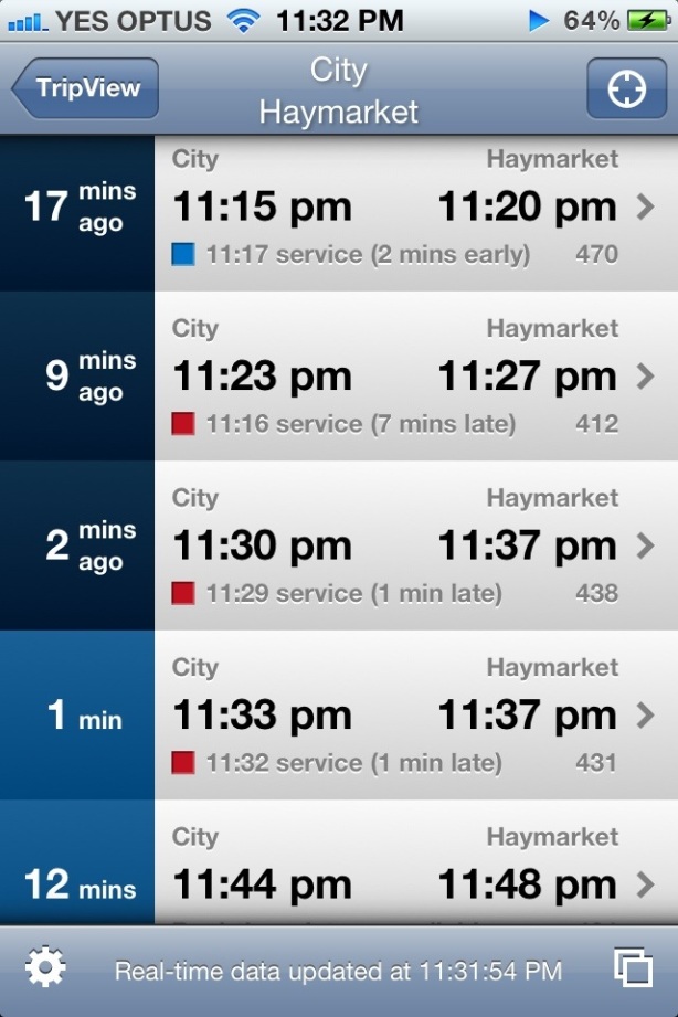
The new TripView app shows the actual time above and the original timetabled time below, next to a square coloured to indicate whether it is early (blue), on time (green), or late (red).

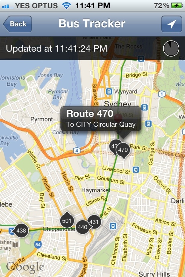
The real time data can also be displayed in map format, in a similar manner to the Fink Labs app from 2011, but with one important improvement – it now tells you the direction the bus is going.

20121219-013903.jpg

TripView also includes a map showing the actual location of all the buses that will go from the origin to the destination of your designated trip, indicated by the green line. A triangle indicates which direction the bus is moving in.

The main shortfalls of TripView are that it does not allow multi-modal trips, and you need to know the exact origin and destination of your journey. For example, if you are going from the city to Castle Hill, it won’t tell you whether the best way to get there is to get a direct bus, or to take a train to Parramatta and then change for a bus. You have to work that out yourself. And if a train and bus is the faster option, then you have to do 2 separate searches. Also problematic is that if you tell it that you are going from a specific bus stop, then it won’t consider telling you to walk around the corner to catch a bus from another bus stop, even if that is a quicker option. But if you are familiar with the bus and train network, then that’s less of a problem.

TripGo

Pros: multi-modal, real time data, very informative, includes taxis

Cons: Interface is clumsy

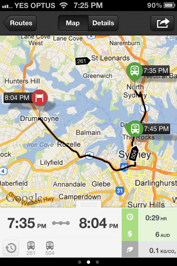
At first, TripGo looks like the poor sibling of TripView. In actuality, it’s something inbetween Google Transit and TripView. Like Google Transit, it provides multi-modal trips (including driving and bicycles), and like TripView it provides real time bus data. In addition, it also has taxis as an option, and allows you to sort the alternatives by cost in dollars, trip length, carbon emissions or first to arrive at destination if you leave now. This also means you don’t need to have an understanding of the transport network. It also makes use of your address book and calendar when setting up your trip.

This app is new, and has some teething problems. For example, it sometimes complains that the origin and destination are too far away, doesn’t factor in the airport station access fee in the cost of getting the train to the airport, or recommends driving to and parking at central station before getting a train from there.

TripGo

Where it misses the mark is on the user interface, which just feels a bit clumsy. That in itself is enough to keep me from using it on most occassions. Though if I’m making a trip to or from an unfamiliar location for the first time, I’d consider using it just that once to gather my bearing. But after that I’d probably stick to either Google Transit or TripView.