Posts Tagged ‘Sydney Metro West’

The new Labor Government’s decision to review Sydney Metro West has led to speculation that additional stations could be added to the line. The previous government resisted calls to do this as it would have added travel time, opting to keep a 20 minute journey between Parramatta and the CBD as a core goal of the new line. However, with tunnelling already underway, the alignment and depths of the tunnels pose a challenge for adding new stations, with the currently planned stations being 18m-30m below ground but potential stations being as deep as 91m. In addition, new stations will likely add to construction costs that have already blown out from $15bn to as high as an estimated $27bn. The incoming government may seek to recoup some of this with new residential developments, a strategy that is consistent with more stations.

The most glaring segment in terms of lack of stations is the 7km between Parramatta and Sydney Olympic Park. An additional station or even two could fit in this segment. Camellia is possible, if the alignment is re-routed. Stations at Rosehill or Silverwater would be too deep unless the tunnel depths are adjusted. However, a station at Newington appears possible, given the change in NSW Government priority on housing. A recent SMH article suggests that Camellia and Silverwater, both in this segment, were the most likely additions to the line.

A station for Camellia was investigated and looked positive as it “could be located in the future Camellia Town Centre, offering an opportunity for an interchange with the future Parramatta Light Rail and supporting urban renewal” (Metro West EIS 2020, p. 3-4). However, this would be on a Northern alignment that is different from the final choice of a Southern route between Parramatta and Sydney Olympic Park. Building a station here would require a redesign of the tunnel alignment. This is easier for this part of the line, as even before delays to the project Tunnel Boring Machines were not set to begin digging here until the final quarter of 2023.

Though not initially investigated, two station locations are possible at Rosehill. One where the old Rosehill Station was located (point 10 on the map above), next to the racecourse itself. However, this would be 42m deep. The other option is at the Rosehill service facilty (point 12 on the map above). This is a much shallower 27m deep, but provides limited connectivity.

A station at Silverwater was rejected because it “would not align with the Government’s current strategic land use vision to retain essential urban services in this area” (Metro West EIS 2020, p. 3-4) due to the significant industrial land. A services facility is currently planned for Silverwater (roughly point 17 on the map below) but this is 44m deep.

A Newington station shows the most promise. It was initially rejected because it “would not align with the current strategic land use vision for this area which seeks to retain the existing residential community without any significant increase in density, enabling the retention and protection of essential industrial and urban services land in adjoining Silverwater” (Metro West EIS 2020, p. 3-5). However, with the new Labor Government seeking to rezone and redevelop land, a station at Newington (point 20 on the map above) at just over 30m deep seems like the most likely option that does not involve re-designing the tunnel routes.

Sydney Metro West has another long segment, with 5km between Five Dock and The Bays. An additional station could be possible, either at Lilyfield or Leichhardt North. However, on closer inspection neither seems likely at this stage in the project.

A station at Lilyfield is possible at two locations. First is at Callan Park (point 48 on the map above), but would be 91m deep and entirely heritage listed, thus limiting any potential development. The other is at Leichhardt Oval (point 46 on the map), but this would still be 58m deep and again lack opportunity for redevelopment that the government would likely seek when adding new stations.

A station at Leichhardt North was initially rejected as it “would present challenging constructability and deliverability due to interaction with the Rozelle Interchange and Hawthorne Canal” while also requiring a “very deep station” (Metro West EIS 2020, p. 3-7). A convenient station location is available next to the Leichhardt North light rail station, as the NSW Government purchased the Dan Murphys site for the Westconnex project but then never used it. However, as of July 2023, the two Tunnel Boring Machines progressing West are 250m from Balmain Road, and would need to change direction for a new Southern alignment around there. This would take time and so a quick decision would need to be made. Given that the NSW Government is awaiting the results of a review into Metro West that is still months away and that any delays would add to costs, this would appear unlikely.

The final option for additional stations on the line involves extending the line East past the CBD terminus at Hunter St. The City of Sydney has been calling for a station at Zetland for quite some time, while Federal MP for Sydney Tanya Plibersek recently added her name to the list of those calling for a station at Zetland.

VIDEO: Sydney Metro: West project update, October 2019 (Transport for NSW)

The locations of 6 stations on the Sydney Metro West between Westmead and the Sydney CBD have been confirmed. Two locations of potential stations currently under investigation at Rydalmere and Pyrmont as well as the Sydney CBD station are still unconfirmed. When complete, the government boasts the line will connect the Sydney CBD to Parramatta in 20 minutes and the Sydney CBD to Sydney Olympic Park in 14 minutes.

The line is set to open in 2030, according a Sydney Morning Herald report. Future extensions are also under consideration, both West to the future Nancy Bird Walton Airport and the nearby Aerotropolis as well as East along the Anzac Parade corridor.

Station Locations

The new Westmead Station (left) will be located immediately South of the existing Westmead Station. The new Parramatta Station (centre) will be located North of the existing Parramatta Station, largely under what is currently a multi-storey car park on Macquarie St. The new Sydney Olympic Park Station (right) will be located immediately East of the existing Sydney Olympic Park Station.

The new North Strathfield Station (left) will be located immediately East of the existing North Strathfield Station. The new Burwood North Station (centre) will be located about 1km North of the existing Burwood Station, on the corner of Parramatta Rd and Burwood Rd. The new Five Dock Station (right) will serve a new catchment not currently served by rail and be located about 600m North of Parramatta Rd along the on the Great North Rd.

The new Bays Precinct Station will be located somewhere between Glebe Island and the White Bay Power Station. The new Sydney CBD Station is rumoured to be likely located between Wynyard and Martin Place Stations along Hunter St. Rydalmere and Pyrmont Stations are not yet confirmed nor are there public details on exact locations.

Commentary: Journey Speed vs Coverage

The government’s deal breaker on this new line has for a long time been a single number: 20 minutes. This new line must provide a 20 minute journey from the Sydney CBD to Parramatta. This appears to be more important a goal than providing rail transport to dense or growing parts of Sydney that currently lack access to rail transport. It also appears to be a more important goal than providing opportunities for urban renewal.

The result is long distances between some stations. Potentially as long as 7km between Parramatta and Sydney Olympic Park or 5km between Five Dock and the Bays Precinct. Most stations are 2km apart, meaning that anyone along the line’s route is no more than 10-15 minutes walking distance to the nearest station, roughly the distance that most people are willing to walk to a train station.

The soon to be fully completed metro line from Tallawong to Bankstown followed a similar pattern, which sees large distances between many stations: 6km between Cherrybrook and Epping, 4km between Chatswood and Crows Nest, or 4km between Waterloo and Sydenham.

For a metro style line that provides high frequency services under dense or growing precincts, there are three likely reasons: to cut down on cost, the increase journey speeds, or to avoid local opposition from so called “NIMBY” (not in my backyard) groups fearful that a metro station brings change to urban fabrix of their neighbourhood. In this particular case, the government has been as clear as it can that the reason is the second one, it is all about fast journeys. The irony of this is that at the same time they are considering a dog-leg detour out to Rydalmere for a potential station, which would increase travel times far more than including a station along a more direct route.

And yet the lack of stations remains a missed opportunity. So one potential solution would be to build in spaces for future stations. Two future stations between Pattamatta and Sydney Olympic Park, one between Five Dock and the Bays Precint, as well as the proposed station at Pyrmont would achieve this goal. By not building a station at Rydalmere, which itself will be served by light rail direct to Parramatta starting in 2023, the cost savings could be used to create empty station boxes at these locations. A hypothetical example of this was published by Fantasy Sydney Rail (see below). This also avoids all 3 potential challenges: cost blowouts, long journey times, and opposition by local residents.

It then falls on a future government to take the small step of building these stations once the network matures. By making these “missing links” with a cost in the hundreds of millions of dollars each, compared to billions or tens of billions for a new rail line, it increases the chances of these locations getting improved rail transport in the future as they begin to develop higher densities.

It may well be one way for the government to get both journey speed and coverage.

VIDEO: Sydney Metro bids thanks and farewell to the Sydney Monorail, Transport for NSW (31 Aug 2017)

This is an updated version of a previous post from March 2016.

Below is a list of all the railways that Sydney might expect in the near future. It only includes heavy rail (i.e. Sydney Trains or Sydney Metro, but not light rail) and includes both new lines or extensions to existing lines. Railways must have been proposed by the state or federal government, so any railways proposed only by local councils or lobby groups are not included nor any railways mentioned exclusively in internal government documents not intended for public release. Also excluded are railways previously announced but since cancelled.

Under construction: Sydney Metro Northwest

The current incarnation of this line was announced in 2010, with construction commencing in 2014. It is scheduled to open in 2019. This line consists of 23km of new track between Epping and Cudgegong Rd near Rouse Hill as well as the conversion of the existing 13km Epping to Chatswood Line (opened in 2009) to metro operation.

A line with a similar alignment was originally announced in 1998 (connecting to the Northern Line at Eastwood rather than Epping), but cancelled in 2008 in favour of a metro line that was itself also cancelled. It has previously been known as the North West Rail Link and Sydney Rapid Transit.

2015-02-20 NWRL

Alignment of the Sydney Metro Northwest from Cudgegong Rd to Chatswood. Click to enlarge. (Source: Transport for NSW.)

Under construction: Sydney Metro City and Southwest

This line was announced in 2014, with construction commencing in 2017. It is scheduled to open in 2024. This line consists of 13km of new track between Chatswood and Sydenham as well as the conversion of the existing 17km Bankstown Line between Sydenham and Bankstown to metro operation.

Sydney Metro City and Southwest Alignment 2016

Sydney Metro City and Southwest alignment. Click to enlarge. (Source: Transport for NSW.)

Announced: Sydney Metro West

This line was announced in 2016, with no date currently set for construction to commence. It is scheduled to open in the second half of the 2020s, though the government is understood to be keen to fast track a 2026 opening date. Stations have been confirmed for Parramatta, Sydney Olympic Park, the bays precinct, and the Sydney CBD.

Four options are currently being considered, with a Metro Rapid option firming as the favourite providing the highest benefit-cost ratio. This option involves a 20 minute journey between Parramatta and the Sydney CBD, with trains travelling between 10 stations at up to 130km/hour, with a benefit-cost ratio of 2.5.

UPDATE: However, the favoured option appears to be the Metro Local South. This option involves a 25 minute journey between Parramatta and the Sydney CBD, with trains travelling between 12 stations at up to 100km/hour, with a benefit-cost ratio of 2.3 when the sale of air rights to development above stations is taken into account.

2016-10-18-west-metro-and-cbd-metro-alignment

Planned route of the 2008 West Metro, which may be indicative of the future Sydney Metro West. Click to enlarge. (Source: Railway Gazette)

Announced: Leppington to St Marys extension

Technically not yet announced, the government is understood to be about to announce an extension of the existing T2 Line from Leppington to the T1 Line at St Marys via a new Western Sydney Airport at Badgerys Creek. Previous investigations into an extension of the South West Rail Link from Leppington also included a Southern extension to Narellan. This extension provides the greatest potential for a freight rail connection to the new airport, whereas a metro connection would be unlikely to provide the opportunity for freight trains to reach the new airport.

2014-05-04 swrl-extension-corridor-map

The proposed corridors for an extension of the SWRL through to Badgerys Creek and beyond. Click to enlarge. (Source: Transport for NSW.)

NSW Premier Gladys Berejiklian has indicated her preference is for a rail connection after the airport opens and further commented that “Some major airports around the world take up to 10 years to build a rail line”. With a 2026 scheduled opening date for a Western Sydney Airport, this would suggest a 2026-36 opening date for an airport railway.

Meanwhile, Federal Opposition Leader Bill Shorten announced his support in April 2017 for a North-South rail connection, but went further in calling for it to be completed in time for the opening of a Western Sydney Airport in 2026. So although there is a difference in opinion on timing, there is now bipartisanship support for a rail line connecting the airport to Leppington and St Marys.

Proposed: Cudgegong Rd to Marsden Park extension

Work on preserving a corridor to extend the Sydney Metro Northwest began before construction on the line had even begun. Two options were considered: a Northern extension to Riverstone and a Western extension to Marsden Park via Schofields. The latter option was chosen with the potential to extend it further to the Mount Druitt area, although the corridor is to be reserved with mode neutrality. In other words, it could be both as an extension of Sydney Metro, but it could also be built as even bus rapid transit/light rail or even heavy rail with double deck trains from the T1 Western Line at Mount Druitt or St Marys.

NWRL Extension Corridor Options

Two options exist for linking the NWRL to the Richmond Line. One goes North West to Vineyard, the other continues west through Schofields and towards Marsden Park. Click to enlarge. (Source: http://northwestoptions.com.au)

Proposed: Bankstown to Liverpool extension

This proposal would see the Sydney Metro extended from the currently planned terminus at Bankstown out to Liverpool.

Such a line could link both Bankstown and Liverpool to Bankstown Airport, allowing for potential redevelopment of the current airport site. That would be in line with the Government´s pattern of building new transport infrastructure in places that enable new developments, including Waterloo, Sydney Olympic Park, the Bays Precinct, or the proposed redevelopment of Long Bay Prison. It would also provide connections between Liverpool and the Sydney CBD via Bankstown that are set to be lost once the Bankstown Line is converted to Metro services by 2024.

VIDEO: Sydney Metro: Future Options – Bankstown to Liverpool (Transport for NSW)

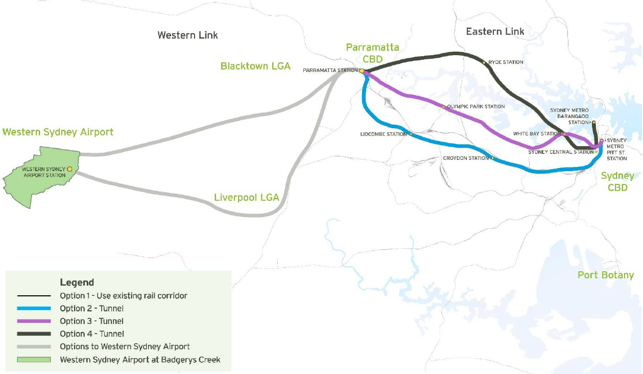
Proposed: Parramatta to Western Sydney Airport extension

A Western extension to the Sydney Metro West, this line would link up Parramatta with a Western Sydney Airport at Badgerys Creek. With the airport and metro line each scheduled to open in 2026 or later, much of

Prime Minister Malcolm Turnbull has called for a rail link to the airport to be built by the year 2046, but not necessarily ready to open simultaneously with a Western Sydney Airport. However, this was before the NSW Government opted for a North-South rail link from Leppington to St Marys, which is set to be announced jointly with the federal government.

2016-03-12 Parramatta Fast Rail Route

Potential alignments for a fast rail connection from Parramatta to a Western Sydney Airport at Badgeries Creek and the Sydney CBD. Click to enlarge. (Source: Parramatta City Council, Western Sydney Airport Fast Train – Discussion Paper, page 12.)

Proposed: City to Long Bay extension

An Eastern extension of the Sydney Metro West, this line would link up the Sydney CBD to the South East along a former tram reservation on Anzac Parade. To this date, there is no official government proposal for this line, only an unsolicited proposal from 2016.

However, Infrastructure NSW has been investigating the Anzac Parade corridor since 2014. The plans would involve the sale of the Long Bay Prison for redevelopment, which itself would help to fund the construction costs of a rail line down that corridor. This is in line with similar plans for Waterloo, the Bays Precinct and Sydney Olympic Park where new metro lines would support redevelopment that would in turn be enabled by the new metro line.

So far, this corridor has been investigated for an extension of the currently under construction light rail line out to Kingsford. Despite this, the close correlation between the unsolicited proposal and line actually being planned at the moment are close enough that an extension to La Perouse via Long Bay appears like a good proxy for official government policy.

VIDEO: Sydney Metro West, Transport for NSW (13 Nov 2016)

When first proposed by the then State Opposition in 2010, the principal aim of the CSELR (CBD and South East Light Rail) was to reduce congestion by adding additional capacity to the Anzac Parade Corridor. Ironically, one of the major criticisms of the line today, in 2017 a full 2 years before it is due to open, is that it will not provide sufficent additional capacity. Instead, the argument goes, a metro line should have been built from the beginning. The recent decision to defer, in effect abandon, a planned light rail line between Parramatta and Olympic Park in favour of a metro line would appear to reinforce this argument.

(All this puts aside the shortcomings of the arguments against the CSELR from the recent Randwick Council report – click here and go to pages 32-34 for the report itself; that being it assumes express bus services are set to be scrapped and thus total capcity along the corridor will decrease. The express buses into the CBD along the Eastern Distributor are not only to be retained, but expanded. So the main shortcoming of the CSELR is not that it will reduce capacity, but rather that it will not increase capacity sufficiently to handle the projected growth in coming years.)

Route of the CBD and South East Light Rail Line. Click to enlarge. (Source: Transport for NSW)

Route of the CBD and South East Light Rail Line. Click to enlarge. (Source: Transport for NSW)

In the case of both light rail lines, it appears that they have been a victim of their own success. Local Councils in Randwick and Parramatta pushed for the construction of light rail to improve transport capacity, often in the belief that this was a realistic improvement to lobby for. These were then taken up by the state government and soon began to appear insufficient. In the case of the CSELR, the project has matured so much that it is effectively too late to cancel and start again as a metro. In the case of the Olympic Park project, the change from light rail to metro was possible, but will push back the introduction of rail to that corridor by many years. If these plans are successful, eventually a metro line from Parramatta to Long Bay will provide heavy rail capacity along both of these corridors. Thus providing heavy rail capacity where light rail was first proposed.

Parramatta Light Rail route map. Click to enlarge. (Source: Transport for NSW)

Parramatta Light Rail route map. Click to enlarge. (Source: Transport for NSW)

This raises a key question: why didn´t this happen from the start? There are two likely answers.

One was that the studies into these corridors began with a transport solution (light rail) for a particular corridor first, then tested whether it would be viable (yes) second. They should have identified a congested corridor first, then identified the ideal transport solution(s) second.

Another reason for this was the lack of sufficient funding. Heavy rail is much more expensive than light rail. As an imperfect comparison, the cost of the CSELR ($2.1bn) is much less than the estimated cost of a metro from Parramatta to the CBD ($11bn). Indeed, a Parramatta to CBD metro has been little more than lines on a map until NSW privatisations brought in more money than was initially expected.

Planned route of the 2008 West Metro, which may be indicative of the future Sydney Metro West. Click to enlarge. (Source: Railway Gazette)

Planned route of the 2008 West Metro, which may be indicative of the future Sydney Metro West. Click to enlarge. (Source: Railway Gazette)

The solution to all of these problems would appear to be simple: let Transport for NSW do its job. Have them identify corridors that need upgrades to transport infrastructure. Then let them decide what the best options are for those corridors, along with the cost for each option. The government of the time can then make decisions based on what they can afford at each moment. The good news is that this already happens. The last Transport Masterplan in 2012 operated in this manner.

The problem arises when politicians or interest groups have their special pet projects. It results in deciding on a mode of transport first and then looking for somewhere to build it. This is an answer in search of a question. It´s backwards and temptations to engage in such actions must be rejected by both decision makers and the pubic at large.

With an updated 5 yearly transport plan due this year, now is the time to go back to letting Transport for NSW do its job.