Posts Tagged ‘Sydney Metro’

The new Labor Government’s decision to review Sydney Metro West has led to speculation that additional stations could be added to the line. The previous government resisted calls to do this as it would have added travel time, opting to keep a 20 minute journey between Parramatta and the CBD as a core goal of the new line. However, with tunnelling already underway, the alignment and depths of the tunnels pose a challenge for adding new stations, with the currently planned stations being 18m-30m below ground but potential stations being as deep as 91m. In addition, new stations will likely add to construction costs that have already blown out from $15bn to as high as an estimated $27bn. The incoming government may seek to recoup some of this with new residential developments, a strategy that is consistent with more stations.

The most glaring segment in terms of lack of stations is the 7km between Parramatta and Sydney Olympic Park. An additional station or even two could fit in this segment. Camellia is possible, if the alignment is re-routed. Stations at Rosehill or Silverwater would be too deep unless the tunnel depths are adjusted. However, a station at Newington appears possible, given the change in NSW Government priority on housing. A recent SMH article suggests that Camellia and Silverwater, both in this segment, were the most likely additions to the line.

A station for Camellia was investigated and looked positive as it “could be located in the future Camellia Town Centre, offering an opportunity for an interchange with the future Parramatta Light Rail and supporting urban renewal” (Metro West EIS 2020, p. 3-4). However, this would be on a Northern alignment that is different from the final choice of a Southern route between Parramatta and Sydney Olympic Park. Building a station here would require a redesign of the tunnel alignment. This is easier for this part of the line, as even before delays to the project Tunnel Boring Machines were not set to begin digging here until the final quarter of 2023.

Though not initially investigated, two station locations are possible at Rosehill. One where the old Rosehill Station was located (point 10 on the map above), next to the racecourse itself. However, this would be 42m deep. The other option is at the Rosehill service facilty (point 12 on the map above). This is a much shallower 27m deep, but provides limited connectivity.

A station at Silverwater was rejected because it “would not align with the Government’s current strategic land use vision to retain essential urban services in this area” (Metro West EIS 2020, p. 3-4) due to the significant industrial land. A services facility is currently planned for Silverwater (roughly point 17 on the map below) but this is 44m deep.

A Newington station shows the most promise. It was initially rejected because it “would not align with the current strategic land use vision for this area which seeks to retain the existing residential community without any significant increase in density, enabling the retention and protection of essential industrial and urban services land in adjoining Silverwater” (Metro West EIS 2020, p. 3-5). However, with the new Labor Government seeking to rezone and redevelop land, a station at Newington (point 20 on the map above) at just over 30m deep seems like the most likely option that does not involve re-designing the tunnel routes.

Sydney Metro West has another long segment, with 5km between Five Dock and The Bays. An additional station could be possible, either at Lilyfield or Leichhardt North. However, on closer inspection neither seems likely at this stage in the project.

A station at Lilyfield is possible at two locations. First is at Callan Park (point 48 on the map above), but would be 91m deep and entirely heritage listed, thus limiting any potential development. The other is at Leichhardt Oval (point 46 on the map), but this would still be 58m deep and again lack opportunity for redevelopment that the government would likely seek when adding new stations.

A station at Leichhardt North was initially rejected as it “would present challenging constructability and deliverability due to interaction with the Rozelle Interchange and Hawthorne Canal” while also requiring a “very deep station” (Metro West EIS 2020, p. 3-7). A convenient station location is available next to the Leichhardt North light rail station, as the NSW Government purchased the Dan Murphys site for the Westconnex project but then never used it. However, as of July 2023, the two Tunnel Boring Machines progressing West are 250m from Balmain Road, and would need to change direction for a new Southern alignment around there. This would take time and so a quick decision would need to be made. Given that the NSW Government is awaiting the results of a review into Metro West that is still months away and that any delays would add to costs, this would appear unlikely.

The final option for additional stations on the line involves extending the line East past the CBD terminus at Hunter St. The City of Sydney has been calling for a station at Zetland for quite some time, while Federal MP for Sydney Tanya Plibersek recently added her name to the list of those calling for a station at Zetland.

Sydney traditionally had a radial public transport network. Trains and buses did and still do a pretty good job of carrying passengers from most parts of Sydney into and out of the CBD. The CBD also acts as an interchange point, allowing these passengers to transfer to another mode or vehicle before going on to a non-CBD location. What it hasn’t done well in the past is catering to circumferential journeys, one that may be a short distance but still requires passengers to make the much longer trip into the city and back.

For these sorts of journeys, a grid system works better. Given that Sydney’s transport system radiates outwards, this grid can be thought of like a spider’s web, with the rail network forming the lines radiating outwards (green) and frequent bus routes crisscrossing them (blue), other than where the Harbour acts as a natual barrier.

This style of network multiplies, rather than adds, the number of destinations available to a passenger, as it connects their initial mode of transport to a number of other routes or lines which they can transfer onto and reach their ultimate end point. A network based on transfers is often better than one designed around a single seat journey.

However, to work, this requires three things:

  1. Easy transfer points from one mode/vehicle to another. In most cases this would mean hopping off a bus right in front of a train station or vice versa without the need for a long walk.
  2. Minimal fare penalty when changing from one mode/vehicle to another. Transfer are an inconvenience (though one that can actually improve mobility in this case) which should not be seen as a premium service with a premium fare. The $2 Opal transfer discount has gone a long way to minimise this, but standardising fares from the ground up to either reflect the total distance travelled regardless of mode or adopting a zonal fare system would be even better.
  3. High frequency services with headways of no more than 5-10 minutes. Many lines and routes now enjoy 15 minute frequencies all day including weekends and evenings, but where a transfer is required this often isn’t frequent enough.

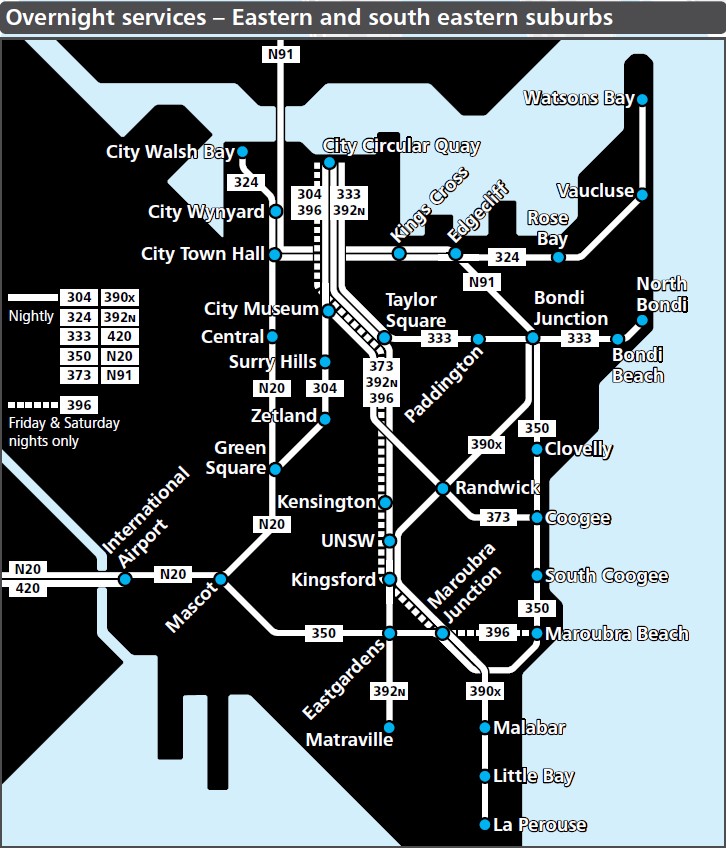
Transport for NSW has shown a willingness to move in this direction in recent years, particularly on the final point with their all day high frequency services. Most stations now have a train every 15 minutes and those with a train every 10 minutes have been on the rise. Bus network redesigns in the Eastern Suburbs, North Shore/Northern Beaches, and North West Sydney, have seen a greater focus on a grid-like network of high frequency buses which also act as feeder services to the rail lines that link the various parts of metropolitan Sydney. This is highlighted most clearly by the Eastern Suburbs overnight bus network, comprised primarily of the all day high frequency routes, illustrated below.

However, one part of Sydney that seems perfectly suited for this sort of network but has yet to receive this treatment is the Inner South West. An area roughly bound by the T4, T8, T3, and T1 lines which all broadly parallel each other East-West; from Olympic Park and Burwood in the North through to Hurstville and Rockdale in the South. Some bus routes running perpendicular to them North-South would easily achieve such a network if frequencies were sufficient. An example of what part of this might look like is shown below.

This example above involves 3 bus corridors that would run at 5-10 minute frequency all day (inlcuding evenings and weekends), crisscrossing the rail lines that would also run at similar frequencies:

  • Hurstville to Beverly Hills and then Wiley Park. This might potentially make a detour via the Roselands Shopping Centre and could go via Lakemba instead of Wiley Park. It could then continue North along A3 to Sydney Olympic Park.
  • Carlton to Kingsgrove and then to Belmore. It could then continue North to Belfield and finally Strathfield.
  • Rockdale to Bexley North and then to Campsie. It could then continue North to Burwood and finally the future Burwood North station on Sydney Metro West.

Some of this frequency is already in place or about to be. The final corridor listed above is already covered by the 420 bus route that links Rockdale to Campsie via Bexley North and already runs every 10 minutes all day. Meanwhile, T3 is set to be converted to metro in 2024 and also run at 10 minute frequencies.

In the past, Transport for NSW has generally waited until major rail improvements come online before redesigning the bus networks around them. This happened in the North West following the opening of the North West portion of Sydney Metro and in the Eastern Suburbs following the opening of the L2/L3 lines of Sydney Light Rail. This may suggest that such a redesign could be on its way to the Inner South West in the coming years once Sydney Metro is extended out to Bankstown.

A roughly 80km new metro line could eventually run from Epping to Schofields via Parramatta, Liverpool, the new Western Sydney Airport, and St Marys based on government plans announced as part of last month’s Commonwealth budget. Such a line, if built as suggested, would involve the conversion of the existing T5 Cumberland Line between Leppington and Merrylands to metro, plus extensions at either end from Leppington to the future Sydney Metro Greater Western Sydney at Bradfield in the South and from Merrylands to Epping via Parramatta in the North.

These plans are based on part of the budget which Federal Urban Infrastructure and Cities Minister Paul Fletcher described as the Commonwealth Government providing “$77.5 million for a business case for Stage 2 of the Sydney Metro – WSA line from Bradfield to Glenfield, via Leppington, which will connect the new $5.3 billion Western Sydney International (Nancy-Bird Walton) Airport when it opens”.

An extension from Leppington to Bradfield has been mooted for quite some time. The March 2018 Western Sydney Rail Needs Scoping Study stated “An extension of the existing line from Leppington to the Badgerys Creek Aerotropolis interchange, connecting with the North-South Link and East-West Link, would provide extra connectivity across the south-west. This South West Link from Leppington to the Badgerys Creek Aerotropolis interchange would cost up to $2 billion (2017 dollars)”. This was reinforced by the November 2020 Future Transport Strategy 2056 report, which illustrated (below) a future rail line incorporating the extension to Bradfield (then known as the Aerotropolis Core), but also a Northern extension to Epping via Greater Parramatta.

However, there were no hints at the time as to whether this would be an extension of the Sydney Trains network, or a conversion to Sydney Metro as happened with the Epping to Chatswood or Bankstown Lines.

Instead, it now appears as though this could initially be a metro line from St Marys to Glenfield, possibly within the next two decades. An extension from St Marys to Schofields via Marsden Park has been mooted for a number of years already. Meanwhile, conversion of the T5 Cumberland Line and extension to Epping requires some speculation.

One possible scenario could involve extending the current metro line from Bankstown to Liverpool then a short underground extension from Merrylands to Parramatta. This would provide interchange options for passengers at Glenfield, Liverpool, and Parramatta (as well as St Marys and Schofields). A simultaneous construction of an additional track between Cabramatta and Liverpool would allow T3 trains from Lidcombe to also continue through to Liverpool. The Parramatta terminus could then be extended further to Epping to complete the line. Were this to happen, then Sydney Metro West could feasibly also be extended from Bradfield South to Macarthur, originally planned as the Southern extension for the metro from St Marys to Bradfield.

An 80km metro line from Epping to Schofields would be long, but roughly the same distance as a currently planned metro line from Schofields to Liverpool (approximately 75km). It would also be a similar distance to a metro line from Macarthur to La Perouse (approximately 80km), which could be on the cards if such plans do become a reality.

However as stated earlier, at this stage this is purely speculation based on a single government announcement providing funding for a business case. In addition, with state and federal elections set to occur in the next 12 months and two changes of government being a real possibility, there remains the strong chance that this business case gets thrown in the bin, like many before it.

VIDEO: Bankstown Station Upgrade (Transport Vlog)

Sydney’s public transport network was traditionally a point to point network focussed on the Sydney CBD and a few other major activity centres. The past decade and a half has seen that network begin to evolve into one based on frequency and transfers where a user can potentially get from anywhere to anywhere. This has been driven by an improvement in service frequencies, initially to 15 minutes but more recently every 10 minutes, and by reforming the fare system to remove or at least reduce the financial penalty for making a transfer.

Towards the end of the 00s, an umbrella group known as the Sydney Alliance showed how much of Sydney had public transport service every 15 minutes. It showed that while public transport services reach all parts of Sydney, only a small portion of the city benefited from 15 minute frequencies and these were concentrated around the inner suburbs.

The first widescale use of an all-day high frequency public transport network came in 2008 with the rollout of Metrobus, red-branded buses along trunk corridors like Anzac Parade or Parramatta Rd. They would operate every 10 minutes during peak hour and every 15 minutes in the off peak, then every 20 minutes in the late evening and on weekends. A total of 13 routes were created, but no new routes were added following the 2011 change of government and all routes have since been withdrawn, replaced, or renumbered.

The rail network began seeing all-day high frequency in the 2013 timetable change. Prior to the 2013 changes, 82 of the 176 stations on the network had a train service every 15 minutes all day. After the 2013 changes, this rose to 113 of the 176 stations.

Stations with a train every 15 minutes: 82 blue stations pre-2013, 31 green stations added post 2013.

The 2017 timetable changes saw this increase further, to 126 of the 176 stations, while also extending these service levels to the weekend; before this, weekend frequencies often remained half hourly at many of these stations. Today, outside of the Richmond Line and T4 South of Wolli Creek, it’s hard to find a station without 15 minute frequencies. Those that do lack 15 minute frequencies often tend to have some of the lowest patronage on the network.

Lines with a train every 15 minutes or less all day in 2017. (Source: Adapted by author from Sydney Trains.)

Separately, in 2016, Opal fares were reformed to provide a $2 transfer discount. In many cases, this eliminated most or all of the penalty for changing from one mode to another. The Opal card had already eliminated the fare penalty from changing from one bus to another. These were important changes, as they enabled the public transport network to evolve from a point to point system, to one involving transfers at key nodes. But this would require a level of frequency greater than a service every 15 minutes.

And so in recent years the term “all day high frequency” service emerged to mean a service every 10 minutes, generally all day 7 days a week.

A few train stations had this level of service: the City Circle saw many branching lines converge and funnel large numbers of trains into it, while the T4 Eastern Suburbs Line and its evenly spaced 6 trains an hour also had a train every 10 minutes. The 2013 timetable brought the T8 Airport Line up to 8 trains an hour, with 6 and 9 minute gaps between each one ensuring no one had to wait more than 10 minutes for their next train. Finally in 2019 the opening of Sydney Metro, which has all day frequencies of 10 minutes, necessitated increasing frequencies on the T1 North Shore Line so that it also had connecting trains every 10 minutes or better.

Stations in Sydney with a train every 10 minutes all day. Some stations have 11 or 12 minute gaps or do not have 10 minute services on weekends.

Today, a few other parts of the rail network also have 10 minute frequencies or similar. Stations like Newtown, Ashfield, and Strathfield as well as a few stations on the Western Line between Parramatta and Blacktown enjoy enough frequency of trains to have roughly 10 minute frequencies. Although in some cases there can be 11 or 12 minute gaps due to different stopping patterns. All three light rail lines normally run trams at 10 minute or better frequencies.

Eastern Suburbs all day high frequency bus network shown in dark blue.

But it is the bus network that has seen the most progress when it comes to an all day high frequency network. Though these routes can be found all across Sydney, such as the T80 between Parramatta and Liverpool in South West Sydney or the 610 between QVB and Castle Hill in North West Sydney, they are most commonly found in the Eastern Suburbs region and the North Shore/Northern Beaches region following a network redesign of each of these two areas.

North Shore and Northern Beaches all day high frequency buses shown in dark blue, plus B-Line in orange.

A network redesign like this is not a new idea. Former Sydney based transport planner Jarrett Walker suggested a potential redesign for Sydney’s inner suburbs back in 2010, during the Metrobus era. What has changed since then is the Opal fare structure now allows such a network to exist without financially penalising users for making a transfer.

With the expansion of Sydney Metro in the West and South West of the city, and the potential for additional bus network redesigns, there remains a lot of untapped potential in increasing mobility for public transport users across Sydney beyond the simple point to point network previously offered.

Sydney Metro could expand to 6 independent lines by the year 2056 and a rail link from Parramatta to Epping may have been quietly dropped, according to an August 2020 report released last week by Transport for NSW. These 6 lines would include a line from Parramatta to La Perouse; a line between Randwick and Miranda; two North/South lines connecting Norwest to Kogarah and Macquarie Park to Hurstville/Kogarah; Sydney Metro Western Sydney Airport; plus a line from Rouse Hill to Bankstown.

The report, titled “South East Sydney Transport Strategy”, focuses on the South Eastern suburbs of Sydney and provides most detail on the preferred transport options for that region. The Sydney Metro West line, currently slated to open in 2030, would be extended Eastwards to La Perouse by 2041, with six metro station locations identified: Zetland, Randwick, Maroubra Junction, Maroubra, Malabar, and La Perouse. A new metro line from Randwick to Kogarah via Kingsford Smith Airport and onwards to Miranda would then be built by 2056, with six metro station locations identified: Randwick, Eastlands, two stations at Sydney Airport, and Kograh. This preferred option was most similar to what was dubbed the “Compact City” scenario (map below), with a few adjustments. The compact city scenario saw a station at Kensington rather than Randwick and no station at the International Airport Terminal, whereas the preferred option saw the UNSW station moved East to Randwick and two stations at the airport rather than one.

An alternate plan, dubbed the “Mass Transit Nodes” scenario (map below), suggests what an expansion of metro lines in Eastern Sydney could look like. It contained an extension of the line from Randwick out to Bondi Beach via Bondi Junction, a line that was last proposed by the NSW Government in 1999 as an extension of the T4 Eastern Suburbs Line from the current terminus at Bondi Junction. It also shows stations at Kensington and Zetland, plus a third metro line for the region connecting Coogee to the Bays Precinct.

Although this option was not selected, it does provide context to the planning behind Transport for NSW’s final choice. This would be in preparation for a future Sydney where rail would focus more on a grid like network that would allow passengers the ability to travel to a dispersed range of destinations with one or more transfers, rather than the current radial system based around getting as many passengers into a central business district as quickly as possible.

Two additional North/South metro lines are also mentioned in the report, in very fine print next to Kogarah Station (map below). The first is a line from Kogarah to Norwest via Parramatta, with a proposed completion date of 2041. The second is a line from Kogarah to Macquarie Park, with a proposed completion date of 2056. Though past reports have listed a line from Hurstville to Macquarie Park, page 204 of the 2018 Greater Sydney Services And Infrastructure Plan does list “a potential mass transit/train link from Hurstville (or Kogarah) to Burwood and Strathfield and then potentially on to Rhodes and Macquarie Park” as a 20+ year visionary transport link. Therefore, this suggests Kogarah could be firming up as a significant transport interchange, with 4 train lines passing through this station.

Absent is any mention of a rail link from Parramatta to Epping. The current plans appears to prefer to avoid branching, with two lines connecting at Randwick, so it would be a logical extension of this to assume that any line from Kogarah to Norwest would be a single line rather than one that branches at Parramatta to link both Norwest and Epping.

Commentary: This is the rail network Sydney needs, but can we afford it?

Sydney has had a very radial rail network. With the exception of a few lines with low frequency and low patronage, such as the T5 Cumberland Line or T7 Olympic Park Line, all of its rail lines are designed to funnel passengers into the Sydney CBD. Planned future lines continue this radial system, but still to just 3 main centres: the Sydney CBD, Parramatta, and the Western Sydney Aerotropolis.

The South East Sydney Transport Strategy is the first time that multiple lines are proposed which act in a circumferential, rather than radial, manner. That is, they help to connect the many radial lines that already do or will soon exist. They will allow passengers to reach a larger number of destinations more quickly than if they have to first travel somewhere like the Sydney CBD to make a transfer. Many successful European and Asian cities operate with this system of nodes and transfers, with rapid and high frequency transport links inbetween.

Indeed, back in 2017 when Rodd Staples, then head of Sydney Metro and now head of Transport for NSW, was asked what mass transit project Sydney needed the most he suggested rail lines that would create a grid like network. He specifically listed a line connecting Hurstville to Bankstown to Olympic Park to Macquarie Park. Though this exact line does not exist in last week’s report, a very similar one from Kogarah to Macquarie Park does. Other lines, such as one from Miranda to Bondi Beach or Coogee to the Bays Precinct, also do not pass through any of Greater Sydney’s major CBDs, yet show up as potential lines under consideration.

By mid century, Sydney is projected to have a population the size of London’s, a city with 10 metro lines. Sydney’s current commuter network has the equivalent of 4 lines (3 centred around Sydney and 1 around Parramatta). So the additional 6 lines mooted in this report, bringing Sydney up to 10, are just what is needed to keep up with population growth. Yet with single stages of new lines, let alone a whole line, costing $10bn to $20bn; this is set to be an expensive expansion of Sydney’s infrastructure, likely to cost hundred of billions of dollars. This is more than the total cost of the NBN or Job Keeper, both national programs.

But there is no alternative to building it, Sydney’s population will inevitably grow and it will need the infrastructure to support it. COVID may give a false sense of tranquility in terms of population growth, but it’s worth remembering that past population growth projections have always been exceeded in recent decades, so even a conservative outlook could mean current projections will merely be met. The question for Sydney residents therefore is not whether to build it, rather how the government of NSW can pay for it; how the people of Sydney will pay for it. This may mean further privatisations, higher taxes, or increased government debt. None are popular, but the alternative is worse; so now is the time to start deciding how, not if.


VIDEO: Sydney Metro: West project update, October 2019 (Transport for NSW)

The locations of 6 stations on the Sydney Metro West between Westmead and the Sydney CBD have been confirmed. Two locations of potential stations currently under investigation at Rydalmere and Pyrmont as well as the Sydney CBD station are still unconfirmed. When complete, the government boasts the line will connect the Sydney CBD to Parramatta in 20 minutes and the Sydney CBD to Sydney Olympic Park in 14 minutes.

The line is set to open in 2030, according a Sydney Morning Herald report. Future extensions are also under consideration, both West to the future Nancy Bird Walton Airport and the nearby Aerotropolis as well as East along the Anzac Parade corridor.

Station Locations

The new Westmead Station (left) will be located immediately South of the existing Westmead Station. The new Parramatta Station (centre) will be located North of the existing Parramatta Station, largely under what is currently a multi-storey car park on Macquarie St. The new Sydney Olympic Park Station (right) will be located immediately East of the existing Sydney Olympic Park Station.

The new North Strathfield Station (left) will be located immediately East of the existing North Strathfield Station. The new Burwood North Station (centre) will be located about 1km North of the existing Burwood Station, on the corner of Parramatta Rd and Burwood Rd. The new Five Dock Station (right) will serve a new catchment not currently served by rail and be located about 600m North of Parramatta Rd along the on the Great North Rd.

The new Bays Precinct Station will be located somewhere between Glebe Island and the White Bay Power Station. The new Sydney CBD Station is rumoured to be likely located between Wynyard and Martin Place Stations along Hunter St. Rydalmere and Pyrmont Stations are not yet confirmed nor are there public details on exact locations.

Commentary: Journey Speed vs Coverage

The government’s deal breaker on this new line has for a long time been a single number: 20 minutes. This new line must provide a 20 minute journey from the Sydney CBD to Parramatta. This appears to be more important a goal than providing rail transport to dense or growing parts of Sydney that currently lack access to rail transport. It also appears to be a more important goal than providing opportunities for urban renewal.

The result is long distances between some stations. Potentially as long as 7km between Parramatta and Sydney Olympic Park or 5km between Five Dock and the Bays Precinct. Most stations are 2km apart, meaning that anyone along the line’s route is no more than 10-15 minutes walking distance to the nearest station, roughly the distance that most people are willing to walk to a train station.

The soon to be fully completed metro line from Tallawong to Bankstown followed a similar pattern, which sees large distances between many stations: 6km between Cherrybrook and Epping, 4km between Chatswood and Crows Nest, or 4km between Waterloo and Sydenham.

For a metro style line that provides high frequency services under dense or growing precincts, there are three likely reasons: to cut down on cost, the increase journey speeds, or to avoid local opposition from so called “NIMBY” (not in my backyard) groups fearful that a metro station brings change to urban fabrix of their neighbourhood. In this particular case, the government has been as clear as it can that the reason is the second one, it is all about fast journeys. The irony of this is that at the same time they are considering a dog-leg detour out to Rydalmere for a potential station, which would increase travel times far more than including a station along a more direct route.

And yet the lack of stations remains a missed opportunity. So one potential solution would be to build in spaces for future stations. Two future stations between Pattamatta and Sydney Olympic Park, one between Five Dock and the Bays Precint, as well as the proposed station at Pyrmont would achieve this goal. By not building a station at Rydalmere, which itself will be served by light rail direct to Parramatta starting in 2023, the cost savings could be used to create empty station boxes at these locations. A hypothetical example of this was published by Fantasy Sydney Rail (see below). This also avoids all 3 potential challenges: cost blowouts, long journey times, and opposition by local residents.

It then falls on a future government to take the small step of building these stations once the network matures. By making these “missing links” with a cost in the hundreds of millions of dollars each, compared to billions or tens of billions for a new rail line, it increases the chances of these locations getting improved rail transport in the future as they begin to develop higher densities.

It may well be one way for the government to get both journey speed and coverage.

Over 100,000 people used Sydney Metro today on its first day open to the public, with no fare charged for those travelling between Chatswood and Tallawong. It was the first time in Australia that a driverless train line operated with passengers, but was not without teething issues and delays.

The trains, which travel at a maximum speed of 100km per hour, had a noticeably quick acceleration and deceleration, and complete the journey from end to end in 37 minutes. Platform screen doors are in use and the gap between platform and train is minimal. The stations themselves were modern and fully accessible.

Indicators above each train door show where the train is along the line, as well as showing how far the train has progressed towards the next station. Lights above each set of doors flash red when doors are opening or closing, light up solid green when the doors are open, and light up solid white when the doors are closed.

Some problems did occur. Mechanical failures with trains occurred in both the early afternoon and during the evening, leading to delays of roughly 45 minutes and 15 minutes respectively. With Sydney Metro controlling the number of people who could enter stations to reduce overcrowding, this led to a blowout in queues. Chatswood Station saw a conga line emerge starting from 1:30PM. Many of those in the queue had travelled to Chatswood from the Northwest earlier and were now returning home.

Inside the trains, the air conditioning seemed set to maximum and in-train indicators began having problems from early in the day and were soon turned off. As a result, there was little indication that doors were closing, besides the silent flashing lights that went unnoticed by most. This, together with shorter than normal dwell times, led some passengers to get caught by the doors (including some with prams) or unable to enter/exit in time. The dwell times were noticeably longer as the day progressed, with doors remaining open for 30 to 60 seconds at stations. This would no doubt lengthen journey durations if allowed to continue. However, the in-train indicators appeared to be working again by late Sunday evening and dwell times were back down to a reasonable length.

Trains also routinely overshot their platforms early in the day. This blog’s author counted roughly one in every two trains would stop past its platform screen doors in the early afternoon, requiring the train to reverse before opening its doors. However, this problem did not persist into the late afternoon, by when it was no longer occurring.

All in all it was not a perfect first day, but a few inconveniences should not eclipse the significance of the first complete new train line in Sydney in 40 years. Many of these teething issues, such as the overshooting and in-train indicators, appear to have been fixed by the end of the first day. Tomorrow’s morning peak hour will be a big test for the new line. If all goes well, most of today’s problems will be soon forgotten.

NSW voters will on Saturday decide who will govern the state for the next 4 years. Both major parties have put forward plans for how they will provide for the transport needs for the residents of Sydney. This blog post will delve into those plans, as well as some recent history.

The NSW Government has spent much of the past 8 years planning and building 3 major transport projects: Sydney Metro, Westconnex, and the CBD and South East Light Rail. Other than a widened M4, none has yet been completed in time for the 2019 election. It has also seen the introduction of the Opal Card and a significant increase in public transport service frequencies.

Sydney Metro

Sydney Metro was born as the North West Rail Link and suffered much initial criticism for the decision to build it as a single deck, driverless system that would terminate at Chatswood with no concrete plans for a CBD extension. That extension was eventually locked in thanks to the privatisation of government electricity businesses, a tough sell to the public that the government received a mandate for in the 2015 election. By 2024 Sydney will have a Metro running from Rouse Hill in the North West to Bankstown in the South West via the Sydney CBD.

Many of the initial criticisms have dried up and today Sydney Metro is the government’s proudest public transport project, set to open in May of this year $1 billion under budget. It is also set to supplement this first line with two additional lines in the second half of the 2020s: an East-West Line from Parramatta to the Sydney CBD and a North-South Line from St Marys to Badgerys Creek.

Sydney Metro. (Source: Transport for NSW)

WestConnex

WestConnex, an amalgamation of the long planned M4 East and M5 East together with an Inner West Bypass to connect the two, has had more consistent controversy. Private car travel is best when it connects disperse origins to disperse destinations, so orbital “ring roads” are the ideal sort of motorways and highways. Travel into dense centres like the Sydney CBD or Parramatta, requiring high capacity transport options, is best left for public transport which does high capacity well rather than roads which do not.

By being a combination of a radial road (the M4 and M5 extensions towards the Sydney CBD) and an orbital road (the Inner West Bypass), WestConnex was an imperfect project from the start. The re-introduction of tolling, public distrust of privatisation, and opposition from inner city residents have led to loud community opposition. Unlike Sydney Metro, opposition to WestConnex has remained strong and was largely responsible for the election of Greens MP Jenny Leong to the inner-city seat of Newtown in 2015 on a commitment to stop WestConnex.

WestConnex. (Source: Transport for NSW.)

Light Rail

The CBD and South East Light Rail is the smallest of the three major projects based on its budget, but probably the most high profile one given the disruption from construction along George St. Originally set to open in early 2019, the troubled project will now open in two stages: Randwick in 2019 and Kingsford in 2020. Unlike Sydney Metro, which had very limited surface disruptions during construction, is on time, and is under budget; the light rail project is running a year behind schedule, has had its cost blown out by half a billion dollars, and has fed into a broader narrative of a government that has hampered Sydney’s entertainment and night life by discouraging Sydneysiders from going out into the George St retail and nightclub precinct.

Despite this, the benefits of a pedestrianised zone on George St are already beginning to be felt. And if the Gold Coast light rail project is anything to go by, a project that had similar problems during construction that Sydney has, then soon after opening there will be calls to extend the line out to Maroubra or further.

Sydney Light Rail. (Source: http://www.sydney.com.au)

Opal Card

An electronic ticketing system was first promised for the 2000 Olympic Games. The delayed TCard project was eventually scrapped in 2007. It was eventually replaced with Opal, which began its rollout in 2012, with all non-Opal tickets phased out by 2016.

Considering the difficult history of rolling out electronic ticketing, not just in Sydney but also in Melbourne with Myki, Opal saw a relatively painless introduction. There were concerns, principally privacy and the loss of periodical tickets such as weeklies and monthlies. Though mostly the concerns were surrounding the fare structure rather than the technology and hardware.

It should also be noted that a $2 transfer discount was introduced in 2016 and contactless payment with credit or debit cards is now available on all modes of government transport in Sydney bar buses, which will receive their rollout in the near future.

An adult Opal card. Click to enlarge.
(Source: Transport for NSW)

Timetables

Service levels have seen a significant increase in the last 8 years, particularly in the Sydney Trains network where most stations now enjoy a train every 15 minutes all day. This has been combined with a large expansion of rolling stock, allowing older train sets to be retired, with all trains soon set to be air conditioned.

This has not been without problems. A simplification of stopping patterns that came with the new timetables has been opposed by residents along stations they feel have lost out, particularly on the extremes of the T3 Bankstown Line. Meanwhile, a lack of train drivers led to a “meltdown” of the train network at the start of 2018, with insufficient staff to man the increased service levels. This required some paring back of services later that year.

Despite this, increased service levels to provide frequencies approaching a “turn up and go” service is commendable and should be further encouraged, albeit managed better to avoid previous hiccups.

Stations with a train every 15 minutes or less all day. (Source: Adapted by author from Sydney Trains.)

Government vs Opposition Plans

The common theme running through the Coalition Government’s transport projects is imperfection. All their major transport infrastructure projects have their issues, but transport infrastructure is being built. In some cases, unpopular moves like privatisation had to occur to provide the funds to build that infrastructure. It is in light of this that comparison can be made to the Labor Opposition, which has had fewer issues with imperfect projects but instead consistently promised and delivered less of it.

This can be seen most starkly in the 2015 election, where the Sydney Morning Herald described the ALP’s transport plan as “less of the same”. Now in 2019, the Opposition has promised to abandon Sydney Metro South West, WestConnext Stage 3 (the Inner West Bypass and the only portion of WestConnex that acts as an orbital ring road), the Western Harbour Tunnel, the Beaches Link, and the F6 extension. Were it not already so close to completion, the CBD and South East Light Rail would probably also be on the chopping block.

This parallel’s Labor’s last period in office, during which the Epping to Chatswood Rail Link, Airport Line, and Olympic Park Rail Lines were built. It was also responsible for delivery of the M2, Eastern Distributor, Lane Cove Tunnel, and Cross City Tunnel. However, many more projects, particularly public transport projects were cancelled. A rail line from Parramatta to Epping was announced, cancelled, announced, cancelled, then announced again in what was seen as an attempt to throw money at marginal electorates to try to win re-election. A Northwest Metro was similarly announced, cancelled, re-announced as a CBD Metro, then cancelled after spending half a billion dollars. Most of the planned T-Ways, networks of bus only roads, were never built.

The Opposition would argue that it is better to cancel a bad project and redirect resources to a good project. Specifically, it has committed to spending the billion dollars saved from not converting the Bankstown Line to metro on speeding up construction on Sydney Metro West. Their argument has merit, particularly given poor planning seems to have caused many of the headaches from the CBD and South East Light Rail.

The Government would argue that the choice is between the projects as proposed (i.e. imperfect) or nothing at all. They point to the cancelling of projects between 2005 and 2010, during which half a decade of expansion of public transport infrastructure expansion was lost because the choice there wasn’t between an imperfect project or a better one, but an imperfect project and nothing. This argument also has merit given that it’s not hypothetical, it’s recent history.

What this all means

This blog believes that the perfect should not be the enemy of the good. Sydney is going through a huge increase in population and infrastructure needs to keep up. We cannot afford to stop building if doing so risks doing nothing. Cancelling projects, even imperfect ones, is not what Sydney needs right now. That means giving the current government a mandate for another four years and spending those four years pressuring them to improve the imperfect rather than electing a government that will merely cancel them.

VIDEO: Santiago Metro Line 6 opening day, Bambul Shakibaei (3 Nov 2017)

This post will consider how to convert the T8 Airport Line between Revesby and Central as well as the T4 Eastern Suburbs and Illawarra Line between Bondi Junction and Hurstville on the Sydney Trains network to single deck metro operation without the level of disruption planned for the Epping to Chatswood or Bankstown Lines. It will not seek to analyse the merits of whether these lines are better suited to single or double deck operations, just how such a conversion would be possible.

In both cases, the lines would need to be separated from the rest of the network.

For the T8 Airport Line, Trains would begin at the Revesby turn back platform and travel to platforms 22 and 23 at Central Station via the airport. Construction of an additional turnback platform at Revesby would help to maintain a high frequency of service. (CORRECTION: As karan points out in the comments, Revesby already has 4 platforms and therefore does not require construction of an additional turnback platform.) T8 South Line trains would all run express from Revesby and be rerouted via Sydenham, made possible by the removal of T3 Bankstown Line trains once Sydney Metro City and Southwest is completed in 2024. A new set of platforms could also be built at Wolli Creek to allow T8 South Line trains to stop there and maintain a point of easy transfer between lines for passengers before continuing North via Sydenham.

In the case of the T4 Eastern Suburbs and Illawarra Line, any trains South of Hurstville would be rerouted to the City Circle (or Sydney Terminal in the case of South Coast Line trains). This would be possible due to the removal of T3 Bankstown Line and T8 Airport Line trains from the City Circle, thus creating enough spare capacity for T4 Illawarra Line and South Coast Line trains displaced from the T4 Eastern Suburbs Line.

From that point T2 Inner West and T8 South trains would enter the City Circle via Town Hall while T4 Illawarra Line trains (from Cronulla and Waterfall) would enter the City Circle via Museum. T4 Illawarra trains that begin and end at Hurstville would continue through to Bondi Junction as they currently do. This would provide much needed additional capacity to all parts of T4 South of the city, the second most used line in the network after the T1 Western Line.

If the aim is merely further sectorisation of the network, the process can end here. But to achieve metro conversion requires two additional steps: installation of platform screen doors and introduction of driverless trains.

Platform screen doors would come first. This would require trains on each of these lines to be replaced with single deck trains, each having the same configuration of doors as the new driverless trains. However, these trains would continue to have drivers. As both of these new lines would have spare capacity, this changeover could now be achieved by initially adding extra trains, rather than merely replacing existing trains 1 for 1. This means the changeover could occur with little to no loss of seated capacity.

Artists impression of the trains to run on the NWRL at Kellyville Station. Click to enlarge. (Source:Transport for NSW.)

Once all trains on the line are replaced, screen doors could be progressively installed during weekends or overnight. Some individual stations may need to be closed while screen doors are installed, but the line itself will continue to operate.

With screen doors in place, a new set of driverless trains could be rolled out.If this is done exclusively on one line first, these same trains could then be redeployed on the second line to complete the process on both lines with fewer trains.

The driver’s cabs could then be removed and the trains converted to driverless.

None of this would likely be possible before 2030 as it requires the T3 Bankstown Line to be converted to metro in 2024 and would be difficult to implement until the T8 Airport Line reverts to government ownership in 2030. But doing so could convert the T8 Airport Line between Revesby and Central as well as the T4 Eastern Suburbs and Illawarra Line between Bondi Junction and Hurstville to metro style operation.

VIDEO: Sydney Metro bids thanks and farewell to the Sydney Monorail, Transport for NSW (31 Aug 2017)

This is an updated version of a previous post from March 2016.

Below is a list of all the railways that Sydney might expect in the near future. It only includes heavy rail (i.e. Sydney Trains or Sydney Metro, but not light rail) and includes both new lines or extensions to existing lines. Railways must have been proposed by the state or federal government, so any railways proposed only by local councils or lobby groups are not included nor any railways mentioned exclusively in internal government documents not intended for public release. Also excluded are railways previously announced but since cancelled.

Under construction: Sydney Metro Northwest

The current incarnation of this line was announced in 2010, with construction commencing in 2014. It is scheduled to open in 2019. This line consists of 23km of new track between Epping and Cudgegong Rd near Rouse Hill as well as the conversion of the existing 13km Epping to Chatswood Line (opened in 2009) to metro operation.

A line with a similar alignment was originally announced in 1998 (connecting to the Northern Line at Eastwood rather than Epping), but cancelled in 2008 in favour of a metro line that was itself also cancelled. It has previously been known as the North West Rail Link and Sydney Rapid Transit.

2015-02-20 NWRL

Alignment of the Sydney Metro Northwest from Cudgegong Rd to Chatswood. Click to enlarge. (Source: Transport for NSW.)

Under construction: Sydney Metro City and Southwest

This line was announced in 2014, with construction commencing in 2017. It is scheduled to open in 2024. This line consists of 13km of new track between Chatswood and Sydenham as well as the conversion of the existing 17km Bankstown Line between Sydenham and Bankstown to metro operation.

Sydney Metro City and Southwest Alignment 2016

Sydney Metro City and Southwest alignment. Click to enlarge. (Source: Transport for NSW.)

Announced: Sydney Metro West

This line was announced in 2016, with no date currently set for construction to commence. It is scheduled to open in the second half of the 2020s, though the government is understood to be keen to fast track a 2026 opening date. Stations have been confirmed for Parramatta, Sydney Olympic Park, the bays precinct, and the Sydney CBD.

Four options are currently being considered, with a Metro Rapid option firming as the favourite providing the highest benefit-cost ratio. This option involves a 20 minute journey between Parramatta and the Sydney CBD, with trains travelling between 10 stations at up to 130km/hour, with a benefit-cost ratio of 2.5.

UPDATE: However, the favoured option appears to be the Metro Local South. This option involves a 25 minute journey between Parramatta and the Sydney CBD, with trains travelling between 12 stations at up to 100km/hour, with a benefit-cost ratio of 2.3 when the sale of air rights to development above stations is taken into account.

2016-10-18-west-metro-and-cbd-metro-alignment

Planned route of the 2008 West Metro, which may be indicative of the future Sydney Metro West. Click to enlarge. (Source: Railway Gazette)

Announced: Leppington to St Marys extension

Technically not yet announced, the government is understood to be about to announce an extension of the existing T2 Line from Leppington to the T1 Line at St Marys via a new Western Sydney Airport at Badgerys Creek. Previous investigations into an extension of the South West Rail Link from Leppington also included a Southern extension to Narellan. This extension provides the greatest potential for a freight rail connection to the new airport, whereas a metro connection would be unlikely to provide the opportunity for freight trains to reach the new airport.

2014-05-04 swrl-extension-corridor-map

The proposed corridors for an extension of the SWRL through to Badgerys Creek and beyond. Click to enlarge. (Source: Transport for NSW.)

NSW Premier Gladys Berejiklian has indicated her preference is for a rail connection after the airport opens and further commented that “Some major airports around the world take up to 10 years to build a rail line”. With a 2026 scheduled opening date for a Western Sydney Airport, this would suggest a 2026-36 opening date for an airport railway.

Meanwhile, Federal Opposition Leader Bill Shorten announced his support in April 2017 for a North-South rail connection, but went further in calling for it to be completed in time for the opening of a Western Sydney Airport in 2026. So although there is a difference in opinion on timing, there is now bipartisanship support for a rail line connecting the airport to Leppington and St Marys.

Proposed: Cudgegong Rd to Marsden Park extension

Work on preserving a corridor to extend the Sydney Metro Northwest began before construction on the line had even begun. Two options were considered: a Northern extension to Riverstone and a Western extension to Marsden Park via Schofields. The latter option was chosen with the potential to extend it further to the Mount Druitt area, although the corridor is to be reserved with mode neutrality. In other words, it could be both as an extension of Sydney Metro, but it could also be built as even bus rapid transit/light rail or even heavy rail with double deck trains from the T1 Western Line at Mount Druitt or St Marys.

NWRL Extension Corridor Options

Two options exist for linking the NWRL to the Richmond Line. One goes North West to Vineyard, the other continues west through Schofields and towards Marsden Park. Click to enlarge. (Source: http://northwestoptions.com.au)

Proposed: Bankstown to Liverpool extension

This proposal would see the Sydney Metro extended from the currently planned terminus at Bankstown out to Liverpool.

Such a line could link both Bankstown and Liverpool to Bankstown Airport, allowing for potential redevelopment of the current airport site. That would be in line with the Government´s pattern of building new transport infrastructure in places that enable new developments, including Waterloo, Sydney Olympic Park, the Bays Precinct, or the proposed redevelopment of Long Bay Prison. It would also provide connections between Liverpool and the Sydney CBD via Bankstown that are set to be lost once the Bankstown Line is converted to Metro services by 2024.

VIDEO: Sydney Metro: Future Options – Bankstown to Liverpool (Transport for NSW)

Proposed: Parramatta to Western Sydney Airport extension

A Western extension to the Sydney Metro West, this line would link up Parramatta with a Western Sydney Airport at Badgerys Creek. With the airport and metro line each scheduled to open in 2026 or later, much of

Prime Minister Malcolm Turnbull has called for a rail link to the airport to be built by the year 2046, but not necessarily ready to open simultaneously with a Western Sydney Airport. However, this was before the NSW Government opted for a North-South rail link from Leppington to St Marys, which is set to be announced jointly with the federal government.

2016-03-12 Parramatta Fast Rail Route

Potential alignments for a fast rail connection from Parramatta to a Western Sydney Airport at Badgeries Creek and the Sydney CBD. Click to enlarge. (Source: Parramatta City Council, Western Sydney Airport Fast Train – Discussion Paper, page 12.)

Proposed: City to Long Bay extension

An Eastern extension of the Sydney Metro West, this line would link up the Sydney CBD to the South East along a former tram reservation on Anzac Parade. To this date, there is no official government proposal for this line, only an unsolicited proposal from 2016.

However, Infrastructure NSW has been investigating the Anzac Parade corridor since 2014. The plans would involve the sale of the Long Bay Prison for redevelopment, which itself would help to fund the construction costs of a rail line down that corridor. This is in line with similar plans for Waterloo, the Bays Precinct and Sydney Olympic Park where new metro lines would support redevelopment that would in turn be enabled by the new metro line.

So far, this corridor has been investigated for an extension of the currently under construction light rail line out to Kingsford. Despite this, the close correlation between the unsolicited proposal and line actually being planned at the moment are close enough that an extension to La Perouse via Long Bay appears like a good proxy for official government policy.

Train capacity would be boosted by 10% into Sydney’s CBD and 16% into Central Station by terminating more trains at Central according to plans prepared for the NSW Government in 2014. The plans would seek to increase rail capacity by maximising the use of existing infrastructure rather than building new infrastructure. However, commuters from stations in Sydney’s West such as Penrith would see their trains terminating at Central’s Sydney Terminal, requiring them to change trains if they wish to continue their journey into the CBD.The changes come in the wake of warnings from the Auditor General that Sydney’s rail network requires additional investment to keep up with growing demand. The Sydney Metro CBD and Southwest will be the first increase in heavy rail capacity into the CBD since the 1979 opening of the Eastern Suburbs Line, but is not set to occur until the year 2024.


Performance data published by Sydney Trains indicates that the most crowded lines into the CBD are in order: the T4 Illawarra Line, T1 Northern Line, T1 Western Line, and T3 Bankstown Line. Each line has patronage during the busiest hour of the morning peak equal to between 147% and 158% of total seats. Crowding levels above 135% often result in delays as passengers struggle to enter and exit trains quickly at stations, resulting in fewer trains per hour and thus reducing total line capacity.

The proposed changes would seek to alleviate pressure on each of these four lines.

  • The T4 Illawarra Line would see an increase in TPH (trains per hour) from 18 to 20, the maximum possible under current signalling.
  • The T1 Northern Line would see its capacity boosted via Strathfield from 10TPH to 15 TPH and eventually an increase in capacity via Chatswood when the Sydney Metro is extended to the CBD in 2024.
  • The T1 Western Line would controversially see cuts to services West of St Marys, which would terminate at Central rather than continue on to the CBD, and on the Richmond Line, which would see a reduction in services from 6TPH to 5TPH. This would be offset by an increase in services between Parramatta and Central, from 20TPH to 26TPH, by extending the Inner West Line out to Parramatta. However, there would be no increase in the current 16TPH that continue past Central into the CBD.
  • The T3 Bankstown Line would see a 25% increase in services, rising from 8TPH to 10TPH; further increasing to 15TPH in 2024 with the extension of Sydney Metro to Bankstown (albeit with a reduction in seated capacity).


Other changes include lengthening some intercity trains from 8 carriages to 12 carriages, while a pair of peak hour train departing from Epping that currently run with 4 carriages could be doubled to 8 in order to further increase capacity. Together, the final effect of these changes could see capacity (measured in terms of the number of 8 carriage trains) of all lines during the busiest hour of the morning peak increased by 10.1% into the CBD, from 109 to 120 trains, and by 16.5% into Central Station, from 118 to 137.5 trains.

Commentary: Changes like these are a needed stop gap

Seeking ways to increase Sydney’s existing passenger rail capacity without having to resort to large investments into its infrastructure should be welcomed. This is something this blog has been calling for since 2013. While unlikely to be welcomed by those adversely affected, if implementing these proposed changes results in 16% or even 10% increases in capacity to the network overall then it will do a lot to get Sydney moving.

The opposing perspective would argue that all main suburban lines deserve direct rail access into the CBD during peak hour without requiring passengers to change trains. Demoting parts of the Western Line to the same status as the Cumberland or Olympic Park Line sets a clear precedent. This argument contains valid concerns.

Either way, infrastructure investment is still needed to cope with future increases in demand. The Auditor General’s report mentioned above found patronage had grown by 4.3% each year since 2011. At this rate, even a 16% increase in capacity would be absorbed by less than 4 years of patronage growth.

This is why new infrastructure such as the 2 Sydney Metro Lines currently being touted cannot come soon enough. Unfortunately, the 2024 opening date for the CBD and Southwest stage of the first line is already too late to meet existing demand. This is why recent suggestions that a second metro line could be opened between Parramatta and the CBD in the mid 2020s should also be welcomed.

Finally, it’s important to note is that these plans are both internal and old. Many aspects already appear to be obsolete, such as the North Shore Line only running 18TPH (the current timetable operates 19TPH) or referring to the first Sydney Metro line as T8 (current government publications suggest it will be branded with an M rather than a T). The Transport Minister Andrew Constance himself raised this in an interview with the ABC. So treat this more as a guide than actual concrete plans or promises.

VIDEO: Sydney Metro West, Transport for NSW (13 Nov 2016)

When first proposed by the then State Opposition in 2010, the principal aim of the CSELR (CBD and South East Light Rail) was to reduce congestion by adding additional capacity to the Anzac Parade Corridor. Ironically, one of the major criticisms of the line today, in 2017 a full 2 years before it is due to open, is that it will not provide sufficent additional capacity. Instead, the argument goes, a metro line should have been built from the beginning. The recent decision to defer, in effect abandon, a planned light rail line between Parramatta and Olympic Park in favour of a metro line would appear to reinforce this argument.

(All this puts aside the shortcomings of the arguments against the CSELR from the recent Randwick Council report – click here and go to pages 32-34 for the report itself; that being it assumes express bus services are set to be scrapped and thus total capcity along the corridor will decrease. The express buses into the CBD along the Eastern Distributor are not only to be retained, but expanded. So the main shortcoming of the CSELR is not that it will reduce capacity, but rather that it will not increase capacity sufficiently to handle the projected growth in coming years.)

Route of the CBD and South East Light Rail Line. Click to enlarge. (Source: Transport for NSW)

Route of the CBD and South East Light Rail Line. Click to enlarge. (Source: Transport for NSW)

In the case of both light rail lines, it appears that they have been a victim of their own success. Local Councils in Randwick and Parramatta pushed for the construction of light rail to improve transport capacity, often in the belief that this was a realistic improvement to lobby for. These were then taken up by the state government and soon began to appear insufficient. In the case of the CSELR, the project has matured so much that it is effectively too late to cancel and start again as a metro. In the case of the Olympic Park project, the change from light rail to metro was possible, but will push back the introduction of rail to that corridor by many years. If these plans are successful, eventually a metro line from Parramatta to Long Bay will provide heavy rail capacity along both of these corridors. Thus providing heavy rail capacity where light rail was first proposed.

Parramatta Light Rail route map. Click to enlarge. (Source: Transport for NSW)

Parramatta Light Rail route map. Click to enlarge. (Source: Transport for NSW)

This raises a key question: why didn´t this happen from the start? There are two likely answers.

One was that the studies into these corridors began with a transport solution (light rail) for a particular corridor first, then tested whether it would be viable (yes) second. They should have identified a congested corridor first, then identified the ideal transport solution(s) second.

Another reason for this was the lack of sufficient funding. Heavy rail is much more expensive than light rail. As an imperfect comparison, the cost of the CSELR ($2.1bn) is much less than the estimated cost of a metro from Parramatta to the CBD ($11bn). Indeed, a Parramatta to CBD metro has been little more than lines on a map until NSW privatisations brought in more money than was initially expected.

Planned route of the 2008 West Metro, which may be indicative of the future Sydney Metro West. Click to enlarge. (Source: Railway Gazette)

Planned route of the 2008 West Metro, which may be indicative of the future Sydney Metro West. Click to enlarge. (Source: Railway Gazette)

The solution to all of these problems would appear to be simple: let Transport for NSW do its job. Have them identify corridors that need upgrades to transport infrastructure. Then let them decide what the best options are for those corridors, along with the cost for each option. The government of the time can then make decisions based on what they can afford at each moment. The good news is that this already happens. The last Transport Masterplan in 2012 operated in this manner.

The problem arises when politicians or interest groups have their special pet projects. It results in deciding on a mode of transport first and then looking for somewhere to build it. This is an answer in search of a question. It´s backwards and temptations to engage in such actions must be rejected by both decision makers and the pubic at large.

With an updated 5 yearly transport plan due this year, now is the time to go back to letting Transport for NSW do its job.

A metro line connecting Sydney’s CBD to Parramatta is firming as the most likely major rail project to be completed once the currently under construction Sydney Metro opens in 2024. This follows the windfall gains received by the NSW Government in the 99 year lease of its poles and wires, with Daily Telegraph political editor Andrew Clennel citing senior government sources that the highest priority in using the proceeds of the privatisation funds will be a “third Metro line from the CBD to Parramatta — taking pressure off the above-ground rail line which is already near capacity”.

The NSW Government is currently reviewing an unsolicited proposal to build such a line, received in July of this year. The cost is estimated at $10bn and could be partly funded through value capture. This would be possible in sites like the Bays Precinct, Olympic Park, Camellia, and Badgerys Creek. However, it remains uncertain what this means for current plans for a light rail connection from Parramatta to Olympic Park, with suggestions that such a link may be shelved and replaced by a metro rail line.

2017-10-23 All Options.png

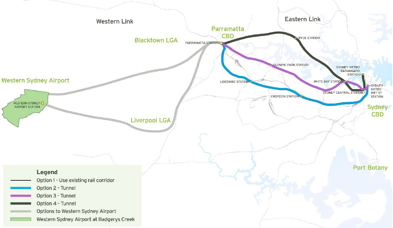
Transport for NSW subsequently published a discussion paper and is now seeking feedback until 28 October. The discussion paper outlines a number of options, split into Options A-E Western Sydney (mostly connecting Parramatta to the Sydney CBD) and Options 1-6 Western Sydney Airport (connecting the new Western Sydney Airport to the rail network).

Option A, a new western metro-style service, would appear to be the proposal being put forward by the consortium and therefore be the front runner. It is described as:

This line requires a tunnel to be built between Sydney and Parramatta / Westmead with stations located every few kilometres. It could operate as a stand-alone, metro-style, all stops service using high capacity single deck trains with the potential to transport 40,000 extra passengers per hour. It could potentially provide journey times between Sydney and Parramatta of around 30 minutes and relieve some demand on the existing network. This could also support opportunities for new developments at locations such as Olympic Park, Five Dock and The Bays precinct.

2016-10-23 Option A.png

Option 5, a direct rail express service from Western Sydney Airport to Parramatta, appears to be the proposal most similar to that being put forward by the consortium and would therefore also be the front runner. However, it involves a 160km/hour express service rather than a metro style service with frequent stops as previous Option A put forward:

This option would include a direct rail express service from the proposed Western Sydney Airport to Parramatta and through to Sydney CBD. This line would require a new tunnel as it approaches Parramatta and from Parramatta through to the Sydney CBD. This service offers the potential for the fastest service between the airport and these two major centres, but would be comparatively expensive to construct. Initial assessments indicate that such a line could achieve journey times of 15 minutes from the proposed Western Sydney Airport to Parramatta and 12 minutes from Parramatta to the Sydney CBD based on a maximum speed of 160 kilometres per hour. While such a service would provide a short travel time to the broader Sydney Basin and CBD, it would not necessarily service the population who are expected to work at and use a Western Sydney Airport in the short-term.

2016-10-23 Option 5.png

This proposal builds on a March 2016 Parramatta City Council feasability study which suggested a fast train rail link along this corridor, providing a 15 minute rail journey from Parramatta to the Sydney CBD that would also connect Parramatta to a Western Sydney Airport.

2016-03-12 Parramatta Fast Rail Route.PNG


Should such a line go ahead, it would pass though and potentially create a new economic corridor for Sydney. The existing “Global Economic Corridor” originally consisted of an zone spanning across Sydney Airport, the Sydney CBD, North Sydney, St Leonards, Chatswood, and Macquarie Park; recently also being expanded to include Norwest Business Park and Parramatta. This new economic corridor would encapsulate Western Sydney Airport, Parramatta, Olympic Park, the Bays District, and the Sydney CBD. This new corridor would pass through Sydney’s 3 cities described by Greater Sydney Commission Chair Lucy Turnbull.

Commentary: How might this line be built?

The Western rail corridor from Parramatta to the Sydney CBD remains one of the most congested in the Sydney network and yet has been seemingly neglected in terms of capacity improvements. Therefore, additional rail capacity is a welcome possibility. What is less certain is how much of it can be paid for with value capture, whether the journey times will be 15 or 30 minutes, and $10bn price tag.

A recent study focused on the Gold Coast Light Rail line found that value capture would be able to pay for only 25% of the capital costs of building the line. Using that as a benchmark suggests that governments will still be liable to fund the majority of the construction costs for major public transport projects. This is also why the windfall gains from recent privatisations is so significant: it makes a project like this possible.

The 15 minute journey time is possible, but unlikely unless the journey is express. The predicted journey times for the 2008 West Metro, which involved a 22km journey that included 10 stations, was 26 minutes. This equates roughly to 45 seconds/km (the equivalent of 80km/hour), plus an additional 1 minute/station. This also corresponds to the estimated journey times for the Sydney Metro currently under construction. So 25-30 minutes would appear a much more realistic journey time than 15 minutes.

2016-10-23 CBD to Parramatta Metro estimated costs.PNG

Finally, there is the construction costs. Here, a lot depends on how the line is constructed and a number of assumptions will be made. The 2008 West Metro is a good starting point, with the adjustment that it pass through the Bays Precinct and then most likely entering the CBD at Barangaroo. This would involve a similar number of stations, but with a slightly shorter length of perhaps 21km rather than 22km. Curiously, this would effectively see a hybrid of the West Metro and CBD Metro alignments, with the 2008 proposed alignments seen in the map below.

2016-10-18 West Metro and CBD Metro Alignment.PNG

Based on the costs of recent projects, but not taking future inflation into account, a more realistic cost could be just under $11bn for the Sydney CBD to Parramatta portion. From Parramatta to Badgerys Creek, the distance is longer at 26km, but about two thirds of this could be above ground rather than in a tunnel. Additionally, it would likely have fewer stations, probably 4 in total not counting Parramatta. So using the same assumptions, that portion of the project could come in at about $6bn.

That is approximately $17bn, approaching double the $10bn cited by the unsolicited proposal. This should come as no surprise, as unsolicited proposals are in the business of selling their case to the government and thus have an interest in underestimating the potential costs.

Finally there is the question of where to run the line through the CBD. The map accompanying the proposal submitted to the Government, published by the Sydney Morning Herald, suggests connecting the line to the future Sydney Metro at Barangaroo and then another line out from Waterloo out to the soon to be redeveloped Long Bay Prison in Sydney’s South East. This would have the benefit of funneling trains from two separate lines on each end of the central portion of this line, ensuring constant high frequency along the CBD portion of the Sydney Metro.

However, it would also place capacity constraints on the line. For example, it would prevent the Northwest line of the Sydney Metro from increasing its current 15 trains per hour during the peak if the Western line of the Sydney Metro were also to enjoy 15 trains per hour. It would be possible to extend the trains from 6 to 8 carriages, providing a 33% increase in capacity, but not the 167% increase in capacity that is currently possible.

The alternative is to build an additional rail line through the CBD. A second corridor under Sussex St has been reserved for such a future line, in addition to the Pitt St corridor that the current Sydney Metro line will use. Alternatively, the line could cross the CBD in an East-West direction, rather than the typical North-South direction that all the existing rail lines follow. This could potentially provide heavy rail access to Pyrmont or Taylor Square.

Either option would be challenging and disruptive. It would ordinarily also be expensive. But it could be transformational in a way very little else could and NSW has recently come across the billions of dollars necessary for such an endeavour.

VIDEO: Central to Eveleigh Urban Transformation Program – Overview (UrbanGrowth NSW)

The NSW Government’s decision to build the Sydney Metro via Waterloo rather than Sydney University was based on the radical densification of the area surrounding a new Waterloo station. The precinct, currently made up of about 2,000 dwellings for public housing, is set to be re-developed with 7,000 dwellings. For a site that is 19 hectares in size, this represents 368 dwellings per hectare or about 700 residents per hectare.

The response has been mostly negative, with criticism emanating from the City of Sydney Council as well as the state opposition, raising concerns that the development is too dense. Comparisons have been made to Green Square, an urban renewal site about 1km South of Waterloo, where an additional 53,000 residents are expected to occupy an area equal to 278 hectares. This represents 190 residents per hectare, much lower than the 700 planned for Waterloo. To find a comparable city with population densities that high requires comparisons with Hong Kong.

Redevelopment sites along the Central to Eveleigh corridor. Click to enlarge. (Source: UrbanGrowth NSW.)

Redevelopment sites along the Central to Eveleigh corridor. Click to enlarge. (Source: UrbanGrowth NSW.)

But that is not a fair comparison. It compares a dense town centre (the Waterloo precinct), where densities are high but are surrounded by lower density residential areas, with entire suburbs (Green Square) or even metropolitan regions (Hong Kong).

A much better comparison would be with the 5.8 hectare Central Park which contains 2,200 residential apartments and 900 units of student accommodation. All together that is 3,100 dwellings which equates to 534 dwellings per hectare, compared to a proposed 368 dwellings per hectare in Waterloo. If Central Park can handle a higher density well, then surely Waterloo can too.

This is an important distinction as Central Park has been hailed as a great success story, one of density done right and in a manner that the community supports. Ironically, some of the same individuals and groups who have supported Central Park and are concerned about reducing Sydney’s housing shortage have also come out to oppose this, a similar project that would achieve that very goal.

The key is density done right. It’s not just a matter of plonking a row of high rise towers on top of a metro station near the CBD and assume they will automatically be a success story. It has to be well planned and well integrated into the existing urban fabric.

That is the debate that should be occurring right now – how to best build the 7,000 new apartments in a way that minimises the impact on existing residents and ensures that they are supported by the necessary infrastructure. Flat out opposing it or scamongering to appease the NIMBY voters is not helping.

VIDEO: Sydney’s New Driverless Train (Sydney Trains Vlog)

12 months ago the NSW Government had already committed to the creation of a light rail network around Parramatta and an extension of the Sydney Metro from Chatswood to Sydenham. But the question remained: which alignments will it choose? At the time, the favourites were a light rail line to Macquarie Park and a metro line via Sydney University.

However, since then the Government opted for a metro line via Waterloo and light rail to Sydney Olympic Park over the previously mentioned alignments. Among the reasons given were the capacity for value capture and the potential for development of new homes.

Parramatta City Council's proposed 4 light rail lines. Click to enlarge. (Source: Western Sydney Light Rail Network: Part 2 Feasibility Report, p. 6)

Parramatta City Council’s proposed 4 light rail lines. Click to enlarge. (Source: Western Sydney Light Rail Network: Part 2 Feasibility Report, p. 6 – no longer available online)

“The light rail corridor will activate a priority growth area and there is an opportunity for the government to share in the value uplift that will occur along the corridor. A Special Infrastructure Contribution will be implemented, with the levy expected to be set at around $200 per square metre of gross floor area of new residential developments subject to consultation.”Transport for NSW (8 December 2015)

“[Light rail] will be a game changer for Sydney’s second CBD – the preferred route provides the most opportunity for new jobs and urban renewal.”Rob Stokes, Planning Minister (8 December 2015)

“Waterloo metro station will be the catalyst for the delivery of an additional 10,000 homes and thousands of new jobs in the precinct for families who live in the area.”Rob Stokes, Planning Minister (16 December 2015)

The first reason given of value capture, involving the contribution to construction costs of new infrastructure by those who benefit from that new infrastructure when their property values rises, is not a new one; but has been gaining in momentum by bureaucrats and politicians at both the State and Federal levels including Prime Minister Malcolm Turnbull. The primary advantage is the ability for new infrastructure to pay for itself, freeing new projects from the constraints of government budgets. The primary limitation is that it tends to be overstated, with Alan Davies arguing that its benefits are modest.

Artists impression of light rail through Sydney Olympic Park. Click to enlarge. (Source: Westline Partnership.)

Artists impression of light rail through Sydney Olympic Park. Click to enlarge. (Source: Westline Partnership.)

The second reason given of potential for new development has arisen due to concerns over housing affordability. Government could address this by either curbing demand (such as reigning in negative gearing/reducing capital gains tax concessions) or increasing supply (often by removing constraints on development due to insufficient infrastructure).

The former policies on demand are almost exclusively in the domain of the Federal Government, while the latter on supply are almost exclusively in the domain of the State Governments. These pressures have shifted Government policy making in recent years, with decisions made based on what will maximise housing construction.

Sydney Metro will include a station at Waterloo, which will also see the Waterloo area undergo significant urban renewal. Click to enlarge. (Source: Transport for NSW.)

Sydney Metro will include a station at Waterloo, which will also see the Waterloo area undergo significant urban renewal. Click to enlarge. (Source: Transport for NSW.)

The net result of all of this is a change in Government priorities. The new priority is all about how to enable the construction of the most housing possible, at the lowest cost to Government possible.

Each of these feeds into the other. Additional housing construction provides additional stamp duty revenue to the Government. Lower net costs allows more infrastructure to be built resulting in more potential housing.

However, it has also meant that transport goals have fallen in priority. In these cases that translates into less connectivity for Sydney and Macquarie Universities as well as Macquarie Business Park.

Chalk it up as a win to the Planning Department and a loss to Transport for NSW.

VIDEO: Metropolitanisationing: Sydney Transport (Jack Walsh)

There are two rail lines in Sydney currently under construction or in the planning phase. The first is the Sydney Metro Northwest, announced in 2010 and set to open in 2019; it consists of 23km of new track between Epping and Cudgegong Rd near Rouse Hill as well as the conversion of the existing 13km Epping to Chatswood Line (opened in 2009) to metro operation. The second is the Sydney Metro City and Southwest, announced in 2014 and set to open in 2024; it consists of 13km of new track between Chatswood and Sydenham as well as the conversion of the existing 17km Bankstown Line between Sydenham and Bankstown to metro operation.

Although no firm plans are currently in place for expansion of the rail network beyond 2024, there are a number of rail lines that have been mentioned by state and federal Transport Ministers, Premiers, and Prime Ministers. In chronological order of their first announcement, these include an extension of the Sydney Metro from Cudgegong Rd to Marsden Park, an extension of the South West Rail Link to Badgerys Creek, an extension of the Sydney Metro from Bankstown to Liverpool, and a new fast train from Parramatta to the Sydney CBD and Badgerys Creek.

(Left out of this list are previously announced rail lines that have been raised in internal government documents or were official government policy but in either case have since been abandoned. These include the Parramatta to Epping Rail Link, a metro line to the Northern Beaches, a metro line to Hurstville, and an extension of the Eastern Suburbs Line to UNSW.)

Cudgegong Road to Marsden Park

Work on preserving a corridor to extend what was then known as the North West Rail Link, now Sydney Metro Northwest, began before construction on the line had even begun. Two options were considered: a Northern extension to Riverstone and a Western extension to Marsden Park via Schofields. The latter option was chosen with the potential to extend it further to the Mount Druitt area, although the corridor is to be reserved with mode neutrality. In other words, it could be both as an extension of Sydney Metro, but it could also be built as even bus rapid transit/light rail or even heavy rail with double deck trains from the T1 Western Line at Mount Druitt or St Marys.

NWRL Extension Corridor Options

Two options exist for linking the NWRL to the Richmond Line. One goes North West to Vineyard, the other continues west through Schofields and towards Marsden Park. Click to enlarge. (Source: http://northwestoptions.com.au)

Leppington to Badgerys Creek

The South West Rail Link would be extended from the current terminus at Leppington through to Badgerys Creek at the new Western Sydney Airport. This line would also include a potential extension North to St Marys and South to Narellan. By connecting to the existing heavy rail network, this line also provides the greatest potential for a freight rail connection to the new airport. However, it does not provide a fast nor a direct rail connection between the airport and Parramatta, the Sydney CBD, nor the existing Kingsford Smith Airport at Mascot.

The proposed corridors for an extension of the SWRL through to Badgerys Creek and beyond. Click to enlarge. (Source: Transport for NSW.)

The proposed corridors for an extension of the SWRL through to Badgerys Creek and beyond. Click to enlarge. (Source: Transport for NSW.)

This is also the only proposed new rail line that is an extension of the existing heavy rail network. All of the other 3 proposals involve extensions of the Sydney Metro network currently under construction or the creation of a new single deck fast train.

Bankstown to Liverpool

An extension of the Sydney Metro City and Southwest, set to open in 2024 between Chatswood and Bankstown via the Sydney CBD, this would see the line extended further out to Liverpool.

The proposed Southern extension of Sydney Metro would see the line extended from the currently planned terminus at Bankstown out to Liverpool. Click to enlarge. (Source: Transport for NSW.)

The proposed Southern extension of Sydney Metro would see the line extended from the currently planned terminus at Bankstown out to Liverpool. Click to enlarge. (Source: Transport for NSW.)

Such a line could link both Bankstown and Liverpool to Bankstown Airport, allowing for potential redevelopment of the current airport site into a new business park. It would also provide connections between Liverpool and the Sydney CBD via Bankstown that are set to be lost once the Bankstown Line is converted to Metro services at some point in the next 8 years.

VIDEO: Sydney Metro: Future Options – Bankstown to Liverpool (Transport for NSW)

Sydney to Parramatta

Parramatta City Council, in conjunction with the Western Sydney Business Chamber, have proposed a fast train from the Sydney CBD to Parramatta that would complete the journey in as little as 15 minutes. It also includes a Western Link between Parramatta and a future Western Sydney Airport at Badgerys Creek.

Potential alignments for a fast rail connection from Parramatta to a Western Sydney Airport at Badgeries Creek and the Sydney CBD. Click to enlarge. (Source: Parramatta City Council, Western Sydney Airport Fast Train - Discussion Paper, page 12.)

Potential alignments for a fast rail connection from Parramatta to a Western Sydney Airport at Badgeries Creek and the Sydney CBD. Click to enlarge. (Source: Parramatta City Council, Western Sydney Airport Fast Train – Discussion Paper, page 12.)

The Eastern Link has 4 potential alignments to Parramatta Station:

  1. Upgrading the existing surface rail corridor with stations at Central, Strathfield, and Lidcombe. This would not reduce travel times by more than a few minutes below the current 25 minute minimum. It would also do the least to add extra capacity.
  2. A tunnel underneath the existing rail corridor with stations at the future Sydney Metro Station in Pitt St, Croydon, and Lidcombe. This has longer journey times than Options 3 or 4 and has limited scope for value capture. However, it provides the most favourable tunneling conditions.
  3. A tunnel South of the Parramatta River with stations at the future Sydney Metro Station in Pitt St, White Bay, and Olypmic Park. This is the shortest and fastest option. It also has the best scope for value capture and most challenging tunneling conditions.
  4. A tunnel North of the Parramatta River with stations at the future Sydney Metro Station in Barangaroo, White Bay, and Ryde. This is longer than Option 3, but passes through more existing centres. It has less scope for value capture but better patronage in the medium term.

The Western Link has 2 potential alignments between Parramatta Station and Badgerys Creek:

  1. A Southern corridor with an intermediate station in Liverpool.
  2. A Northern corridor with an intermediate station in either Blacktown or near the M4/M7.

The Western Link has fewer details than the Eastern Link. Proponents are split over which section to build first, with Parramatta City Council CEO Greg Dyer supporting an Eastern Link and Parramatta MP Geoff Lee supporting a Western Link. Meanwhile, Prime Minister Malcolm Turnbull has called for a Western Link to be built earlier than 2046, but not necessarily ready to open simultaneously with a Western Sydney Airport. Sydney Morning Herald City Editor Jacob Saulwick argues that an Eastern Link is more pressing given the capacity constraints between Parramatta and the Sydney CBD, but that it would be a good stage one for when a future extension to Badgerys Creek becomes needed and built as stage two.

A station at either McEvoy St or Green Square could form part of the new Sydney Metro railway currently under construction according to NSW Government plans. These plans show a range of potential alignment options considered for the line between Central Station and Sydenham, ranging from a Western alignment through Sydney University and Newtown through to an Eastern alignment through Waterloo and Green Square. The Government recently decided that the line should pass through Waterloo, rejecting the Sydney University option. However, these plans pre-date that decision.

Sydney Metro station and alignment options. Click to enlarge. (Source: Chatswood to Sydenham State Significant Infrastructure Application Report, page 51)

Maps of the potential alignments show that a line through Waterloo could go directly to Sydenham, but could also potentially continue South to include an additional station either McEvoy St in Alexandria or Green Square where an existing Airport Line station is located. A station at Green Square could allow for easy transfers between the two lines outside of the congested CBD. These stations have not been mentioned previously by the Government when discussing either the Sydney University or Waterloo options.

The Sydney Metro consists of two stages. Stage one comprises the former North West Rail Link from Rouse Hill to Epping together with the Epping to Chatswood Rail Link, which is scheduled to open in 2019. Stage two consists of a new tunnel from Chatswood to Sydenham together with the conversion of the Bankstown Line from Sydenham to Bankstown, which is set to begin construction next year and open in 2024. The line will operate with driverless single deck trains with limited seating on a frequent turn up and go style timetable.

The Sydney Trains network contains 178 stations. 25 of these stations have all day 10 minute frequencies. This is mostly in the CBD, Eastern Suburbs, Airport Line, and Lower North Shore Line.

The Sydney Trains network map showing all stations and also just the stations with a train every 10 minutes all day. (Source: Sydney Trains.)

The Sydney Trains network map showing all stations and also just the stations with a train every 10 minutes all day. Click to enlarge. (Source: Sydney Trains.)

Prior to 2013 this high frequency network was even smaller, consisting only of the 9 stations on the T4 Line between Wolli Creek and Bondi Junction. This remains the case on weekends, with the 2013 timetable improvements only applying to weekdays and not weekends.

In addition, the T1 Line between Strathfield and Chatswood does have some 11 minute gaps which have been counted as 10 minute frequencies even though the technically do not meet the strict 10 minute criteria. But stations like Hurstville in the South and Parramatta in the West, serviced by 7 and 9 trains per hour respectively, do have 10 minute frequencies if measured at Central Station; however different stopping patterns prevent them from having evenly spread out 10 minute frequencies outside of the CBD.

This distinction is important; as a rule of thumb passengers generally value waiting time twice as much as their travel time. The result of this is that a passenger would rather spend 25 minutes travelling on a train than 10 minutes waiting for a train followed by 10 minutes on the train. The 10 minute waiting time is worth the same as 20 minutes of actual travel time, therefore the second option feels like a 30 minute journey and so passengers would often opt for the first option of 25 minutes. This is even though the first option involves a longer total journey time.

Hypothetical high frequency network achievable by changing stopping patterns rather than adding extra services. (Source: Sydney Trains.)

Hypothetical high frequency network achievable by changing stopping patterns rather than adding extra services. Click to enlarge. (Source: Sydney Trains.)

This high frequency network could hypothetically be expanded by changing the stopping patterns of some trains. This eliminates the need to provide additional services, though may sometimes necessitate additional train revenue service hours. This is not an exhaustive list. For example it leaves out stations like Newtown which could achieve 10 minute frequencies by having all T2 Line trains stop there, rather than just the current 15 minute frequencies resulting from half the T2 Line trains that do stop there.

  1. T1 trains that stop at Strathfield to also stop at Burwood. There are technically trains every 10 minutes at Burwood, but the T2 trains are so slow that they arrive in the CBD after the T1 trains. So what is needed here is for some more of the 13 T1 Line trains that stop at Strathfield every hour to also stop at Burwood.
  2. T4 trains that stop at Sydenham/Wolli Creek to also stop at Tempe. The trains that skip Tempe are not timetabled to run any faster than those that stop there, so this could be done without slowing down the timetable.
  3. T1 and T5 trains between Blacktown and Harris Park to add stops at intermediate stations spaced evenly apart. While the T1 Line has 7 trains per hour passing through this section of the network, there are also 2 trains per hour on the T5 Line, resulting in 9 trains per hour in total. This would not provide 10 minute frequencies into the CBD, but would provide 10 minute frequencies for those getting a train to/from Parramatta or Blacktown.

The Sydney Trains network actually looks a lot better when all day 15 minute frequencies are the benchmark. 113 stations out of 178 (63%) have 15 minute frequencies. This is high enough for turn up and go journeys when only 1 train is required. However, if a transfer is required; such as to another train or between bus and train; then 10 minute frequencies are a much better benchmark for turn up and go services.

Sydney Metro proposed alignment. Click to enlarge. (Source: Project Overview, Sydney Metro.)

Sydney Metro proposed alignment. Click to enlarge. (Source: Project Overview, Sydney Metro.)

Meanwhile, the 10 minute frequency network is set to expand dramatically in 2019 and then 2024 when the 2 stages of the Sydney Metro project are scheduled to begin operation. This new line will also run at 10 minute all day frequencies, and extend these frequencies further out into the outer suburbs of Sydney than is currently the case.

Note: For the second time this year, this blog has taken an unannounced hiatus for a number of months due to the pressures of real life. This post was written up at the end of June but never properly finished and thus not posted. It will probably be the final monthly round up, at least for the foreseeable future. This blog will not be ending, posts will still continue. But instead, the focus will be on specific issues or events as they occur with no set frequency of posts. For now, please enjoy the breaking news from 3 months ago…

VIDEO: Urban Taskforce Research- Who Lives in Apartments (31 May 2015)

2 June: $50m cost blowout for NWRL

The budget for constructing the skytrain portion of the North West Rail Link, an elevated viaduct between Bella Vista and Rouse Hill, has blown out from $340m to $390m. Despite the cost blowout, a project spokesperson said that there has been no change to the completion date for the skytrain, while the Transport Minister Andrew Constance stated that variations in cost had been factored into the full $8.3bn budget and that the overall budget remained unchanged.

The skytrain portion of Sydney Metro, shown at the proposed Rouse Hill Station. Click to enlarge. (Source: Transport for NSW.)

The skytrain portion of North West Rail Link, shown at the proposed Rouse Hill Station. Click to enlarge. (Source: Transport for NSW.)

 4 June: Sydney Rapid Transit renamed Sydney Metro

Sydney’s single deck train network will be known as Sydney Metro, replacing the previous name Sydney Rapid Transit. This follows the passage of legislation authorising the privatisation of state owned electricity assets, which passed both chambers of Parliament the previous day.

4 June: NSW Opposition dumps support for light rail because of Infrastructure NSW Report

The new Shadow Transport Minister Ryan Park, who together with the Opposition Leader Luke Foley recently withdrew their support for light rail down George Street, announced that the change of heart on light rail came after reading the 2012 Infrastructure NSW Report that opposed George Street light rail. The alternative bus tunnel option suggested by the report was criticised by Transport for NSW, with Infrastructure NSW later supporting George Street light rail.

A very early proposed map for the CBD BRT would see a tunnel between Wynyard and Town Hall, removing many buses from the surface streets. Click on image for higher resolution. (Source: First Things First, Infrastructure NSW, page 99.)

A very early proposed map for the CBD BRT would see a tunnel between Wynyard and Town Hall, removing many buses from the surface streets. Click to enlarge. (Source: First Things First, Infrastructure NSW, page 99.)

6 June: Transport corridors in Western Sydney to be reserved

Work to reserve transport corridors in Sydney’s West for an Outer Sydney Orbital motorway, Bells Line of Road to Castlereagh Connection, and South West Rail Link extension is moving into the public consultation phase. The NSW Roads Minister Duncay Gay said that work on the 2 roads was not expected to begin for decades; with the SWRL corridor set to be identified by late 2016.

8 June: Olympic Park becomes preferred light rail option

A light rail line connecting Parramatta to Olympic Park has firmed as the favourite option for a new light rail line in Sydney’s West. The line could extend out to Wesmead in the West and Strathfield in the East. It gained favour after a campaign by businesses and developers who touted the possibility for development of the corridor and the potential for value capture from that development to fund the cost of building the new line. However, local councils have labelled the line a white elephant and are calling for the Government to build a line to Epping instead.

11 June: Opal only gates installed at Wynyard Station

New Opal only gates have been installed as part of the Wynyard Station upgrade. Opal only gates have recently been installed at Olympic Park Station. No date has been set for the full phase out of ticket gates that accept magnetic stripe paper ticket.

https://twitter.com/TheOpalUser/status/608901203326423040

12 June: SWRL connection to CBD via Granville?

Transport blogger Nick Stylianou suggests that Leppington trains may be connected up to the T2 South Line, travelling to the CBD via Granville. This may happen as soon as the end of this year, with Campbelltown to city services running exclusively on the T2 Airport Line.

https://twitter.com/kypros1992/status/609128666828705792

12 June: 65 new transport officers

Sydney’s existing 150 transport officers is set to increase to 215, with an additional 65 transport officers to be hired.

15 June: Trial of backdoor boarding on CBD buses

The Government is set to trial boarding of buses via the back door for 2 weeks. The trial will be restricted to Opal card users between 4PM and 7PM at 7 bus stops in the CBD. Marshals will be present to ensure boarding occurs safely. It is hoped that the trial will see lower dwell times for buses by allowing customers to board more quickly.

VIDEO: Seven News Sydney – Trial of back door loading on buses (15/6/2015)

19 June: Reduction in minimum parking requirements

The NSW Government has announced a watered down version of a minimum parking requirement policy that it announced last year. The new policy allows new apartment blocks in areas well serviced by public transport to have fewer off-street parking spots than is currently mandated by local government regulations. The previously announced policy would have eliminated the requirement for off-street parking entirely and has not been adopted. Supporters of the move argue that it will help to keep construction costs down and help with housing affordability. Opponents of the move claim that it will cause cars to spill over into existing streets where parking is already scarce.

23 June: Barangaroo Station confirmed

A Station at Barangaroo has been confirmed in the Sydney Metro City and Southwest. Stations still to be determined are Artarmon, St Leonards/Crows Nest and either Sydney University or Waterloo.

VIDEO: Sydney Metro Barangaroo Station

The Federal Government’s refusal to fund public transport infrastructure dates back to 4 April 2013, when the then Opposition Leader Tony Abbott declared his opposition to it:

“The Commonwealth government has a long history of funding roads. We have no history of funding urban rail and I think it’s important that we stick to our knitting, and the Commonwealth’s knitting when it comes to funding infrastructure is roads.” – Tony Abbott, Federal Opposition Leader (4 April 2013)

In the 2 years since then, this position has barely changed. Which is to say it has evolved (very slowly) in the right direction.

2014-05-22 Jamie Briggs

The first change came on 16 May 2014, when the Assistant Minister for Infrastructure and Regional Development Jamie Briggs promised that federal funding from its asset recycling fund would not be restricted to roads. It followed through with this promise on 19 February 2015, providing $60m in funding to the ACT for its proposed light rail project. This funding was small, particularly compared to the billions going to the marquee roads projects; it also included a side comment from the Treasurer Joe Hockey’s office that “it has been a controversial project in the ACT” and that “there has been debate as to whether alternative projects may have higher potential economic benefits”.

While the ACT project received lukewarm support from Canberra and could be described as tokenistic in terms of the quantity of funding; the 8 March 2015 decision to send $2bn to NSW changed that. With $1.3bn of that going towards the Sydney Metro project, the Federal Government is now providing more funding to this rail project than the $1bn it has committed to WestConnex. However, the rail funding came with strings attached in the form of requiring privatisation. Funding for WestConnex has no such restrictions.

Warren Truss, Federal Deputy Leader of the Opposition and Federal Shadow Transport Minister (Image: Australian Parliament)

Warren Truss, Federal Deputy Leader of the Opposition and Federal Shadow Transport Minister (Image: Australian Parliament)

14 June 2015 showed more promise on this front, with the Deputy Prime Minister Warren Truss stating that “the Federal Government is quite happy to fund metro rail projects”. This would appear to be in start contradiction to the statements quoted by Mr Abbott earlier that the Federal Government “have no history of funding urban rail” and would not be funding public transport.

Perhaps the reason can be found by winding back the clock a month to 6 May 2015 when Greens leader Christine Milne was replaced by Richard Di Natale. In the past, Ms Milne had been resistant to supporting the re-indexation of the fuel excise because additional revenue would be hypothecated (i.e. promised to) road funding. However, when the Finance Minister Matthias Cormann offered to eliminate the hypothecation Ms Milne maintained her opposition.

The party now has a new leader, and one who appears to be more willing to negotiate with the Government of the day. Following the May budget, Mr Di Natale met with Mr Abbott. In this meeting, he offerred to support indexation if some of the revenue was hypothecated to public transport projects. In that context, Mr Truss’ comments make a lot more sense.

The policy taken to the last election – to not fund urban commuter rail, is a bad one. However, the question here is not whether the Government should abandon it. By funding Sydney Metro to the tune of $1.3bn, it already has abandoned it. Instead, the question is about when the Government will take a mode neutral stance on funding of transport infrastructure. Let Infrastructure Australia or the states determine the best transport projects and fund those. There’s a chance this possibility may become a reality sooner than expected.