Archive for the ‘Urban planning’ Category

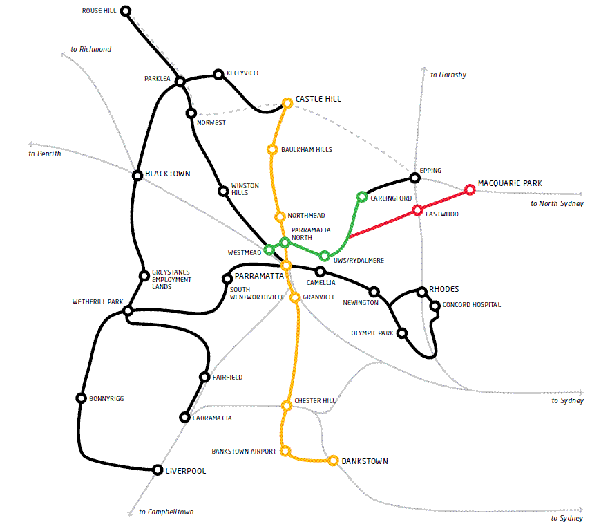
A metro line connecting Sydney’s CBD to Parramatta is firming as the most likely major rail project to be completed once the currently under construction Sydney Metro opens in 2024. This follows the windfall gains received by the NSW Government in the 99 year lease of its poles and wires, with Daily Telegraph political editor Andrew Clennel citing senior government sources that the highest priority in using the proceeds of the privatisation funds will be a “third Metro line from the CBD to Parramatta — taking pressure off the above-ground rail line which is already near capacity”.

The NSW Government is currently reviewing an unsolicited proposal to build such a line, received in July of this year. The cost is estimated at $10bn and could be partly funded through value capture. This would be possible in sites like the Bays Precinct, Olympic Park, Camellia, and Badgerys Creek. However, it remains uncertain what this means for current plans for a light rail connection from Parramatta to Olympic Park, with suggestions that such a link may be shelved and replaced by a metro rail line.

2017-10-23 All Options.png

Transport for NSW subsequently published a discussion paper and is now seeking feedback until 28 October. The discussion paper outlines a number of options, split into Options A-E Western Sydney (mostly connecting Parramatta to the Sydney CBD) and Options 1-6 Western Sydney Airport (connecting the new Western Sydney Airport to the rail network).

Option A, a new western metro-style service, would appear to be the proposal being put forward by the consortium and therefore be the front runner. It is described as:

This line requires a tunnel to be built between Sydney and Parramatta / Westmead with stations located every few kilometres. It could operate as a stand-alone, metro-style, all stops service using high capacity single deck trains with the potential to transport 40,000 extra passengers per hour. It could potentially provide journey times between Sydney and Parramatta of around 30 minutes and relieve some demand on the existing network. This could also support opportunities for new developments at locations such as Olympic Park, Five Dock and The Bays precinct.

2016-10-23 Option A.png

Option 5, a direct rail express service from Western Sydney Airport to Parramatta, appears to be the proposal most similar to that being put forward by the consortium and would therefore also be the front runner. However, it involves a 160km/hour express service rather than a metro style service with frequent stops as previous Option A put forward:

This option would include a direct rail express service from the proposed Western Sydney Airport to Parramatta and through to Sydney CBD. This line would require a new tunnel as it approaches Parramatta and from Parramatta through to the Sydney CBD. This service offers the potential for the fastest service between the airport and these two major centres, but would be comparatively expensive to construct. Initial assessments indicate that such a line could achieve journey times of 15 minutes from the proposed Western Sydney Airport to Parramatta and 12 minutes from Parramatta to the Sydney CBD based on a maximum speed of 160 kilometres per hour. While such a service would provide a short travel time to the broader Sydney Basin and CBD, it would not necessarily service the population who are expected to work at and use a Western Sydney Airport in the short-term.

2016-10-23 Option 5.png

This proposal builds on a March 2016 Parramatta City Council feasability study which suggested a fast train rail link along this corridor, providing a 15 minute rail journey from Parramatta to the Sydney CBD that would also connect Parramatta to a Western Sydney Airport.

2016-03-12 Parramatta Fast Rail Route.PNG


Should such a line go ahead, it would pass though and potentially create a new economic corridor for Sydney. The existing “Global Economic Corridor” originally consisted of an zone spanning across Sydney Airport, the Sydney CBD, North Sydney, St Leonards, Chatswood, and Macquarie Park; recently also being expanded to include Norwest Business Park and Parramatta. This new economic corridor would encapsulate Western Sydney Airport, Parramatta, Olympic Park, the Bays District, and the Sydney CBD. This new corridor would pass through Sydney’s 3 cities described by Greater Sydney Commission Chair Lucy Turnbull.

Commentary: How might this line be built?

The Western rail corridor from Parramatta to the Sydney CBD remains one of the most congested in the Sydney network and yet has been seemingly neglected in terms of capacity improvements. Therefore, additional rail capacity is a welcome possibility. What is less certain is how much of it can be paid for with value capture, whether the journey times will be 15 or 30 minutes, and $10bn price tag.

A recent study focused on the Gold Coast Light Rail line found that value capture would be able to pay for only 25% of the capital costs of building the line. Using that as a benchmark suggests that governments will still be liable to fund the majority of the construction costs for major public transport projects. This is also why the windfall gains from recent privatisations is so significant: it makes a project like this possible.

The 15 minute journey time is possible, but unlikely unless the journey is express. The predicted journey times for the 2008 West Metro, which involved a 22km journey that included 10 stations, was 26 minutes. This equates roughly to 45 seconds/km (the equivalent of 80km/hour), plus an additional 1 minute/station. This also corresponds to the estimated journey times for the Sydney Metro currently under construction. So 25-30 minutes would appear a much more realistic journey time than 15 minutes.

2016-10-23 CBD to Parramatta Metro estimated costs.PNG

Finally, there is the construction costs. Here, a lot depends on how the line is constructed and a number of assumptions will be made. The 2008 West Metro is a good starting point, with the adjustment that it pass through the Bays Precinct and then most likely entering the CBD at Barangaroo. This would involve a similar number of stations, but with a slightly shorter length of perhaps 21km rather than 22km. Curiously, this would effectively see a hybrid of the West Metro and CBD Metro alignments, with the 2008 proposed alignments seen in the map below.

2016-10-18 West Metro and CBD Metro Alignment.PNG

Based on the costs of recent projects, but not taking future inflation into account, a more realistic cost could be just under $11bn for the Sydney CBD to Parramatta portion. From Parramatta to Badgerys Creek, the distance is longer at 26km, but about two thirds of this could be above ground rather than in a tunnel. Additionally, it would likely have fewer stations, probably 4 in total not counting Parramatta. So using the same assumptions, that portion of the project could come in at about $6bn.

That is approximately $17bn, approaching double the $10bn cited by the unsolicited proposal. This should come as no surprise, as unsolicited proposals are in the business of selling their case to the government and thus have an interest in underestimating the potential costs.

Finally there is the question of where to run the line through the CBD. The map accompanying the proposal submitted to the Government, published by the Sydney Morning Herald, suggests connecting the line to the future Sydney Metro at Barangaroo and then another line out from Waterloo out to the soon to be redeveloped Long Bay Prison in Sydney’s South East. This would have the benefit of funneling trains from two separate lines on each end of the central portion of this line, ensuring constant high frequency along the CBD portion of the Sydney Metro.

However, it would also place capacity constraints on the line. For example, it would prevent the Northwest line of the Sydney Metro from increasing its current 15 trains per hour during the peak if the Western line of the Sydney Metro were also to enjoy 15 trains per hour. It would be possible to extend the trains from 6 to 8 carriages, providing a 33% increase in capacity, but not the 167% increase in capacity that is currently possible.

The alternative is to build an additional rail line through the CBD. A second corridor under Sussex St has been reserved for such a future line, in addition to the Pitt St corridor that the current Sydney Metro line will use. Alternatively, the line could cross the CBD in an East-West direction, rather than the typical North-South direction that all the existing rail lines follow. This could potentially provide heavy rail access to Pyrmont or Taylor Square.

Either option would be challenging and disruptive. It would ordinarily also be expensive. But it could be transformational in a way very little else could and NSW has recently come across the billions of dollars necessary for such an endeavour.

Pedestrianising the suburbs

Posted: September 18, 2016 in Urban planning
Tags:

VIDEO: Perth Busport (TransperthOnline)

The Committee for Sydney recently tweeted about the importance of dense intersections in creating better quality urban areas. Small blocks with frequent intersections improve pedestrian movement and lead to better experiences, whereas larger blocks with fewer intersections do the opposite.

In suburban areas, cul-de-sacs often have the effect of calming traffic on the streets, but with the negative side effect of hindering mobility by foot. It effectively forces individuals into their cars in order to get around.

But that is not always the case. Below is a map of Baulkham Hills, the neighbouring suburb to Winston Hills (second from the right in the Committee for Sydney tweet above). The two suburbs are separated by the M2, seen on the right half of the bottom edge of the image below. There are 2 main roads running North-South on either side of the image, with the connecting streets often ending in quiet cul-de-sacs. The 2 main roads, together with the M2, are also where bus routes provide public transport for this area.

The focal point is the small park in the centre of the image. It has 3 cul-de-sacs surrounding it, two to the North (above) and one to the East (right). This park has pathways connecting the park to each of these sul-de-sacs, as well as to the other street just to the West (left), which are all accessible by pedestrians but not to cars.

Satellite image of Baulkham Hills. Click to enlarge. (Source: Google Maps.)

Satellite image of Baulkham Hills. Click to enlarge. (Source: Google Maps.)

Someone in the cul-de-sac to the East would ordinarily be quite isolated. The map below shows the same area, with a red spot showing that particular cul-de-sac and the blue areas shows everywhere accessible within 400m using only streets. This is equivalent to a 5 minute walk and reaches neither of the 2 roads where the buses operate.

As can be seen, it does not provide much coverage and it is this sort of urban design that leads many suburban residents to abandon walking or even public transport in favour of their private car to get around.

2016-09-18-baulkham-hills-pedestrian-catchments

Green areas are accessible only by pedestrians. All areas accessible within 400m of the red spot if only streets are used is shown in blue; if pedestrian only areas are included then all areas accessible within 400m is shown in blue/green/yellow. Click to enlarge. (Source: Open Street Map.)

This is where the park comes in to play. By linking up the 4 surrounding streets, it massively enhances the areas accessible within 400m. An additional 3 pedestrian walkways, also shown in green, provide further access. So the actual areas accessible on foot can be seen in green and yellow as well as the initial blue on accessible by streets only. This has the added benefit of extending the areas within 400m to both the roads where buses operate.

By providing these pedestrian links, the urban design achieves the dual goals of quiet suburban street with limited traffic as well as easy and convenient pedestrian access to a large catchment.

VIDEO: Central to Eveleigh Urban Transformation Program – Overview (UrbanGrowth NSW)

The NSW Government’s decision to build the Sydney Metro via Waterloo rather than Sydney University was based on the radical densification of the area surrounding a new Waterloo station. The precinct, currently made up of about 2,000 dwellings for public housing, is set to be re-developed with 7,000 dwellings. For a site that is 19 hectares in size, this represents 368 dwellings per hectare or about 700 residents per hectare.

The response has been mostly negative, with criticism emanating from the City of Sydney Council as well as the state opposition, raising concerns that the development is too dense. Comparisons have been made to Green Square, an urban renewal site about 1km South of Waterloo, where an additional 53,000 residents are expected to occupy an area equal to 278 hectares. This represents 190 residents per hectare, much lower than the 700 planned for Waterloo. To find a comparable city with population densities that high requires comparisons with Hong Kong.

Redevelopment sites along the Central to Eveleigh corridor. Click to enlarge. (Source: UrbanGrowth NSW.)

Redevelopment sites along the Central to Eveleigh corridor. Click to enlarge. (Source: UrbanGrowth NSW.)

But that is not a fair comparison. It compares a dense town centre (the Waterloo precinct), where densities are high but are surrounded by lower density residential areas, with entire suburbs (Green Square) or even metropolitan regions (Hong Kong).

A much better comparison would be with the 5.8 hectare Central Park which contains 2,200 residential apartments and 900 units of student accommodation. All together that is 3,100 dwellings which equates to 534 dwellings per hectare, compared to a proposed 368 dwellings per hectare in Waterloo. If Central Park can handle a higher density well, then surely Waterloo can too.

This is an important distinction as Central Park has been hailed as a great success story, one of density done right and in a manner that the community supports. Ironically, some of the same individuals and groups who have supported Central Park and are concerned about reducing Sydney’s housing shortage have also come out to oppose this, a similar project that would achieve that very goal.

The key is density done right. It’s not just a matter of plonking a row of high rise towers on top of a metro station near the CBD and assume they will automatically be a success story. It has to be well planned and well integrated into the existing urban fabric.

That is the debate that should be occurring right now – how to best build the 7,000 new apartments in a way that minimises the impact on existing residents and ensures that they are supported by the necessary infrastructure. Flat out opposing it or scamongering to appease the NIMBY voters is not helping.

VIDEO: Sydney’s New Driverless Train (Sydney Trains Vlog)

12 months ago the NSW Government had already committed to the creation of a light rail network around Parramatta and an extension of the Sydney Metro from Chatswood to Sydenham. But the question remained: which alignments will it choose? At the time, the favourites were a light rail line to Macquarie Park and a metro line via Sydney University.

However, since then the Government opted for a metro line via Waterloo and light rail to Sydney Olympic Park over the previously mentioned alignments. Among the reasons given were the capacity for value capture and the potential for development of new homes.

Parramatta City Council's proposed 4 light rail lines. Click to enlarge. (Source: Western Sydney Light Rail Network: Part 2 Feasibility Report, p. 6)

Parramatta City Council’s proposed 4 light rail lines. Click to enlarge. (Source: Western Sydney Light Rail Network: Part 2 Feasibility Report, p. 6 – no longer available online)

“The light rail corridor will activate a priority growth area and there is an opportunity for the government to share in the value uplift that will occur along the corridor. A Special Infrastructure Contribution will be implemented, with the levy expected to be set at around $200 per square metre of gross floor area of new residential developments subject to consultation.”Transport for NSW (8 December 2015)

“[Light rail] will be a game changer for Sydney’s second CBD – the preferred route provides the most opportunity for new jobs and urban renewal.”Rob Stokes, Planning Minister (8 December 2015)

“Waterloo metro station will be the catalyst for the delivery of an additional 10,000 homes and thousands of new jobs in the precinct for families who live in the area.”Rob Stokes, Planning Minister (16 December 2015)

The first reason given of value capture, involving the contribution to construction costs of new infrastructure by those who benefit from that new infrastructure when their property values rises, is not a new one; but has been gaining in momentum by bureaucrats and politicians at both the State and Federal levels including Prime Minister Malcolm Turnbull. The primary advantage is the ability for new infrastructure to pay for itself, freeing new projects from the constraints of government budgets. The primary limitation is that it tends to be overstated, with Alan Davies arguing that its benefits are modest.

Artists impression of light rail through Sydney Olympic Park. Click to enlarge. (Source: Westline Partnership.)

Artists impression of light rail through Sydney Olympic Park. Click to enlarge. (Source: Westline Partnership.)

The second reason given of potential for new development has arisen due to concerns over housing affordability. Government could address this by either curbing demand (such as reigning in negative gearing/reducing capital gains tax concessions) or increasing supply (often by removing constraints on development due to insufficient infrastructure).

The former policies on demand are almost exclusively in the domain of the Federal Government, while the latter on supply are almost exclusively in the domain of the State Governments. These pressures have shifted Government policy making in recent years, with decisions made based on what will maximise housing construction.

Sydney Metro will include a station at Waterloo, which will also see the Waterloo area undergo significant urban renewal. Click to enlarge. (Source: Transport for NSW.)

Sydney Metro will include a station at Waterloo, which will also see the Waterloo area undergo significant urban renewal. Click to enlarge. (Source: Transport for NSW.)

The net result of all of this is a change in Government priorities. The new priority is all about how to enable the construction of the most housing possible, at the lowest cost to Government possible.

Each of these feeds into the other. Additional housing construction provides additional stamp duty revenue to the Government. Lower net costs allows more infrastructure to be built resulting in more potential housing.

However, it has also meant that transport goals have fallen in priority. In these cases that translates into less connectivity for Sydney and Macquarie Universities as well as Macquarie Business Park.

Chalk it up as a win to the Planning Department and a loss to Transport for NSW.

Video: Parramatta Light Rail, 8 December 2015 (Transport for NSW)

Light rail between Parramatta and Olympic Park, announced today, is the culmination of years of planning and proposals for light rail in Western Sydney. To fully recognise the significance of this announcement, it’s worth going back almost 4 years into the past to see how this ultimately developed from the ashes of the Parramatta to Epping Rail Link.

23 December 2011: Parramatta to Epping Rail Link cancelled

The change of state government earlier in the year saw the dropping of the Parramatta to Epping Rail Link as official government policy, which in turn sparked Parramatta City Council to push for a light rail line instead. It sought to mimic the work of Randwick Council, whose pre-feasibility study into light rail to Randwick resulted in the now CBD and South East Light Rail line from getting the green light from the NSW Government. In both cases, light rail would link a CBD, university, stadium, racecourse, and hospital.

30 August 2013: Parramatta City Council commissions light rail feasibility study

The initial pre-feasibility study recommended a 169km light rail network, with lines linking Parramatta to Macquarie Park via Eastwood, Epping via Carlingford, a loop to Olympic Park and Rhodes, Bankstown, Castle Hill, Rouse Hill (on the existing T-Way), and Liverpool (on the existing T-Way). It also included a line from Cabramatta to Rouse Hill via Blacktown and Parklea (on the existing T-Way between these two suburbs).

Parramatta Light Rail

Light rail proposal for Parramatta and its surrounding areas. Stage 1 is in yellow, green and red. Stage two is in black. Click to enlarge. (Source: Parramatta City Council.)

The lines were estimated to cost $9.5bn, based on the cost of the Dulwich Hill light rail extension and Gold Coast light rail.

The final pre-feasibility study by Parramatta City Council concluded that two lines should be built first: one from Westmead to Macquarie Park via Parramatta and Eastwood, the other from Parramatta to Castle Hill via Baulkham Hills and Castle Hill Showground.

Map of the proposed Macquarie Park and Castle Hill light rail lines. Click to enlarge. (Source: Western Sydney Light Rail Network - Part 2 Feasibility Report, pp. 4-5)

Map of the proposed Macquarie Park and Castle Hill light rail lines. Click to enlarge. (Source: Western Sydney Light Rail Network – Part 2 Feasibility Report, pp. 4-5.)

These lines would be 30km in length, cost $1.5bn to build, and require 21 trams in order to provide 10 minute frequencies (Source: Western Sydney Light Rail Network – Part 2 Feasibility Report, p. 5). They would then be followed by two additional lines, one to Bankstown via Chester Hill, the other to Rhodes via Olympic Park.

A potential future network. Click to enlarge. (Source: Western Sydney Light Rail Network: Part 2 Feasibility Report, p. 6)

A potential future network. Click to enlarge. (Source: Western Sydney Light Rail Network: Part 2 Feasibility Report, p. 6.)

8 March 2014: Berejiklian confirms light rail is “in the mix”

Urban Growth NSW, the Government’s development agency, publishes a report about Parramatta showing a light rail alignment on one of its maps. Though not much more than lines on a map, it is the first time that light rail has appeared in an official government report.

When asked about this by the Daily Telegraph, the Transport Minister Gladys Berejiklian confirms that light rail is “in the mix”.

31 March 2014: Robertson commits to light rail feasibility study

The Opposition Leader John Robertson announced plans for a $20m full feasibility study into light rail around Parramatta if elected in 2015. This would build on the Parramatta City Council’s pre-feasibility study completed in 2013.

2 June 2014: Baird commits to light rail feasibility study

The NSW Premier Mike Baird announces a $10m full feasibility study into light rail around Parramatta. Though less than the $20m promised by his opposition counterpart 2 months earlier, this study commences immediately.

17 June 2014: 10 routes shortlisted and funding committed

With a feasibility study underway on 10 potential routes, the NSW Government commits $400m in funding to pay for the new line. An additional $600m would later be committed from the sale of the electricity distribution network, bringing the total funds committed to $1bn.

17 July 2014: Berejiklian suggests light rail should link health and education precincts

The Transport Minister Gladys Berejilkian stressed the importance that any light rail line should connect Parramatta up to both Westmead hospital and Western Sydney University (then still named UWS). With Westmead to Macquarie Park being the only one of the 10 potential routes that passes through both the education and health precinct, this suggested that the Westmead-Parramatta-Eastwood-Macquarie Park alignment that Parramatta City Council had previously pushed would be the one chosen.

28 August 2014: 6,000 new apartments announced for North Parramatta

An announcement by the Premier Mike Baird that a $2bn urban renewal project of North Parramatta would bring 6,000 new apartments builds on the earlier report in March that these developments are likely to be supported by additional infrastructure. The area is located around one of the proposed light rail alignments between Parramatta and Westmead, which heads North from Parramatta before passing Parramatta Stadium and then crossing the Parramatta River on the Northern end of Westmead hospital.

Artists impression of the Parramatta North precinct. Click to enlarge. (Source: Urban Growth NSW.)

Artists impression of the Parramatta North precinct. Click to enlarge. (Source: Urban Growth NSW.)

27 October 2014: 4 routes shortlisted

The earlier 10 routes were reduced to a final 4 routes on the shortlist, which would then be investigated in greater detail. The 2 lines proposed by Parramatta City Council, Parramatta to Macquarie Park via Eastwood and Parramatta to Castle Hill via Windsor Road, did not make the shortlist. Instead, a line to Macquarie Park via Carlingford would be investigate as would a line to Castle Hill via Old Northern Road. In addition to these 2 routes, a line to Strathfield/Burwood via Olympic Park and a line to Bankstown would also be investigated. These again mirror the routes investigated by Parramatta City Council, though its Olympic Park line would extend out to Rhodes rather than Strathfield.

23 February 2015: Westline Partnership promotes benefits of Olympic Park Line over Macquarie Park

A coalition of businesses, developers, and councils begins to push for a line from Parramatta to Olympic Park. The group; calling itself the Westline Partnership and comprising of the ANZ Stadium, the Australian Turf Club, Accor, Dexus, Sydney Olympic Park, Sydney Business Chamber, Auburn council, and Canada Bay council; claims that doing so could unlock $2.9bn of funding through “value capture” in the form of developer levies. Doing so would allow the Government to build two lines, one to Olympic Park and the other to Carlingford, according to Westline Partnership spokesman Christopher Brown.

Artists impression of light rail through Sydney Olympic Park. Click to enlarge. (Source: Westline Partnership.)

Artists impression of light rail through Sydney Olympic Park. Click to enlarge. (Source: Westline Partnership.)

8 June 2015: Olympic Park firms as preferred option

The NSW Government begins to hint that it is shifting from Macquarie Park to Olympic Park as its preferred option.

26 November 2015: Decision on Olympic Park line accidentally revealed

The Roads Minister Duncan Gay accidentally says that light rail will be coming to Olympic Park while outlining improvements to the nearby WestConnex project. Both Olympic Park and Parramatta had recently been hit by the announcement that the Commonwealth Bank would be moving its operations out of both those suburbs and into Redfern’s Australian Technology Park. The move resulted in criticisms towards the NSW Government for not being quicker in its decision making on a route for any Western Sydney light rail line.

8 December 2015: Light rail lines to Olympic Park and Carlingford announced

The Premier Mike Baird announces that two light rail lines are to be built simultaneously from Parramatta: one to Olympic Park and one to Carlingford. Both lines will travel along the same corridor through to Camellia before branching off.

Artists impression of light rail through Parramatta. Click to enlarge. (Source: Transport for NSW.)

Artists impression of light rail through Parramatta. Click to enlarge. (Source: Transport for NSW.)

The project will raise funds through the use of a Special Infrastructure Contribution (SIC), “expected to be set at around $200 per square metre of gross floor area of new residential developments subject to consultation”. This is in addition to the $1 billion already committed by the NSW Government, with the Government also seeking contributions from the federal and local governments.

VIDEO: Shaun Micallef: Australia’s NBN proposals

A High Speed Rail (HSR) network connecting Melbourne, Canberra, Sydney, and Brisbane has been shown to create more benefits than costs while fares would pay the operating costs of trains on such a network. Yet there seems little appetite in the government to build one. Initially, this may appear to be due to the high initial costs of $114bn to build it; but on closer inspection it may be necessary to re-evaluate the way we look at HSR as something for regional Australia rather than just for travel between the capital cities.

Cost benefit analysis suggests that HSR is worth building. The Phase 2 Study found that HSR has a BCR (Benefit Cost Ratio) of 1.1 when a 7% discount rate is used. Thus, the benefits of building HSR are greater than the costs. However, the bulk of these benefits would accrue to the users of HSR in the form of time savings. In 2028 dollars, HSR users would receive $141bn of the total $180bn of benefits that HSR is expected to create. An additional $14bn of benefit go to operator benefits, which help to pay the operating costs and up to $16bn (14%) of infrastructure costs, but this still leaves the government paying for $98bn (86%) of infrastructure spending on HSR. (Sources: HSR Phase 2 Study Executive Summary, pages 42, 9).

This means the government would be subsidising the travel costs of HSR users to the tune of $98bn. This is unlike the NBN, where the initial infrastructure spending is expected to be eventually recouped. The majority of users (65%) would be leisure travellers; however the bulk of the benefits would be realised by business travellers (the remaining 35%), who would receive $93.6bn of the $141bn of benefits. That is because of the higher value attached to their time. This point was raised by Alan Davies in Crikey, who proposed that “if the [time] saving is so valuable to business travellers, they should pay the full cost of constructing the line”. The Phase 2 Study even recognises that these travellers would be willing to pay a higher fare:

“Increasing the cost of fares would increase the financial returns and reduce the funding gap, although doing so would reduce the number of people using the system. Even so, the economic benefits of the program would remain positive.”Source: HSR Phase 2 Study Executive Summary, page 9

Higher fares would have the benefit of reducing the government’s cost below $98bn. However, it would do so by impacting leisure travellers the most, with many choosing not to travel on HSR. Business travellers would mostly still continue to use HSR, but the loss of many leisure travellers would see the total benefit of the project reduced. Although the Phase 2 Study claims the economic benefits in such a situation would still remain positive (i.e. a BCR greater than 1), this may be based on the less conservative 4% discount rate, rather than the more conservative 7% discount rate that is normally applied to transport infrastructure projects. The 1.1 BCR that a 7% discount provides is dangerously close to falling below the 1.0 required for the project to be economically viable. Therefore, as it stands HSR does not appear viable without a $98bn government subsidy, most of which would flow to business travellers who least need government welfare.

An alternative perspective

The Phase 2 Study emphasises that HSR accrues more benefits as time progresses, given the growth in population. If governments work collaboratively and actively to preserve potential HSR corridors then HSR cost increases should be limited. Therefore, HSR becomes more viable as time progresses with benefits growing faster than costs.

Since HSR gains most of its benefits from additional users, one way to increase the viability of HSR is to add additional population to the corridor. This would be much easier to achieve around the regional stations where constraints are much more limited than in the major cities. HSR could act as an enabler, allowing a greater number of people to live and work in regional areas without becoming isolated from those services only available in major cities. The Phase 2 Study’s assumptions of modest population growth in regional towns situated on the HSR route show that this was not considered as part of the feasability for HSR.

In fact, the Phase 2 Study finds that HSR will produce $73.2bn in benefits from intercity travel, more than the $67.5bn in benefits from regional travel (Source: Department of Infrastructure, page 43). This finding that most of the benefits accrue from intercity travel rather than regional travel suggest that not enough is being done to massively develop regional Australia. HSR provides this opportunity which in turn makes HSR more viable.

Proposed East Coast High Speed Rail alignment. Click to enlarge. (Source: Department of Infrastructure, page 17.)

Proposed East Coast High Speed Rail alignment. Click to enlarge. (Source: Department of Infrastructure, page 17.)


This idea was floated by the ABC show Catalyst in its 4 December 2014 episode “Future Cities“, in which Dr Julian Bolleter says:

“So, what we think is really important, as the capital cities grow beyond mid-century, is that we begin to think not so much in terms of mega cities, but mega regions. Essentially, it means chains of smaller cities connected with very good public transport infrastructure. So we could conceive of a mega region running from Brisbane to Sydney through Canberra to Melbourne which is bound together by a high-speed rail link, and those cities will have access to affordable land, and they’ll also be able to be designed from the ground up around the principles of 21st-century sustainability. High-speed rail can travel at about 350km/h, so there’s no city along this mega region that is further than two hours commute on a high-speed train from a capital city.”Source: Dr Julian Bolleter, ABC

Achieving this would require us to rethink how HSR would work in AustraliaShadow Transport Minister Anthony Albanese recently wrote on HSR in which he concluded one well thought out and one not so well thought out point. His statement that “people could live in regional Australia and commute to work in the city” was not well thought out; this is true only to the extent that people can currently commute to work in Sydney by flying into Kingsford-Smith Airport, or any other major city airport. However his point that “companies could establish themselves in the regions, taking advantage of lower costs but comfortable in the knowledge the city was a short train ride away” hits the nail on the head.

In order for HSR to be a success in spurring regional development people need to live, work, and spend leisure time in the same place. Employment opportunities as well as services that are needed on a day to day basis such as health and education would be provided locally. But the existence of HSR provides convenient access to services which are not needed day to day, such as medical specialists or major cultural festivals.

If the 1,700km HSR corridor had a station every 100km or so along major regional cities, and these cities were allowed to grow to 800,000 residents each (as Dr Bolleter suggests in the Catalyst video), then it would be roughly equivalent to a doubling of the existing populations of Sydney and Melbourne combined. Once it becomes prohibitively expensive to retrofit the necessary infrastructure into our growing major cities, it will become cheaper to build it in regional cities even after the cost of HSR is factored in. Australian cities have not reached that point yet, but it remains a question of when rather than if they do reach that point.

Monday: High speed rail costs could be halved

The Australasian Railway Association has released a report showing that, based on international construction costs of $35m/km, a high speed rail line from Brisbane to Melbourne could be built for $63bn. This is significantly less than the $114bn in the Australian Government’s recent high speed rail study.

Tuesday: 4 routes shortlisted for Parramatta light rail

An initial list of 10 possible light rail lines from Parramatta has been cut down to 4, with a final decision to be made in the near future. The government is set to pick a line connecting Parramatta to either Castle Hill, Macquarie Park, Olympic Park, or Bankstown.

Artists impression of light rail in Parramatta. Click to enlarge. (Source: Transport for NSW.)

Artists impression of light rail in Parramatta. Click to enlarge. (Source: Transport for NSW.)

Tuesday: Fuel excise indexation introduced via regulation

The indexation of the fuel excise is to be introduced by the Australian Government despite the Senate having blocked legislation to enable it. Reintroducing indexation will cause the price of petrol to rise by about 1c per year and is expected to raise $2.2bn over 4 years. The move is expected to put pressure on Senators to pass the measure so that the additional revenue raised does not have to be refunded to petrol companies.

Tuesday: Mobile apps to help with accessibility

The Government is calling on app developers to help create a series of apps that will meet the needs of people with a disability using public transport. This is aimed at ensuring compliance with the Disability Discrimination Act to provide better services for people with a disability. “Planning a journey, knowing that our stop is coming up next or even knowing which side of the train to alight from are tasks that most of us take for granted,” a Transport for NSW spokesman said, adding that “for customers with disability or impairment it can be a huge cause of anxiety”. Selected app proposals will receive seed funding, ongoing access to real time transport data as well as promotion of their product by Transport for NSW.

Thursday: Gold Opal card to be released

A Gold Opal card for seniors and pensioners is to be released on Monday 3 November. The card will feature a $2.50 daily cap and also offer free travel after the first 8 journeys each week. Speaking about existing paper tickets for seniors and pensioners, the Transport Minister Gladys Berejiklian said that “the paper Pensioner Excursion Ticket will continue to be available on Monday November 3, and well into the future”. Gold Opal cards can only be obtained online or over the phone.

Thursday: 50,000 new homes for Parramatta Road

An additional 50,000 homes will be built along Parramatta Road over the coming decades, with over two thirds of homes slated for the Western end of these Parramatta Road between Granville and Strathfield. The NSW Government is planning to widen the M4 alongside this portion of Parramatta Road while building the M4 East Tunnel underneath the Eastern portion of Parramatta Road as part of its WestConnex project.

Map of the WestConnex freeway. Click to enlarge. (Source: RMS)

Map of the WestConnex freeway. Click to enlarge. (Source: RMS)

Friday: Whitlam Station proposed for NWRL

The terminus station on the North West Rail Link (NWRL) could be named Whitlam, after Blacktown City Council proposed naming a new suburb after the former Prime Minister. The station is currently known as Cudgegong Road.

https://twitter.com/BlacktownNews/status/527695515060682753

VIDEO: Man races a train to the next stop

Tuesday: Parking minimums for new developments scrapped

New developments near transport hubs in and around the inner city will no longer be required to include parking spaces as part of government reforms to planning laws. Including a parking space can add an additional $50,000 or more to the cost of a unit, with the changes designed to allow inner city residents who do not need or want a parking space from being forced to pay for one. Developers can still choose to include parking spaces, should market demand for them exist. Opposition to the plan prevented it from being extended to outer suburban locations, with critics worried that it would result in cars spilling over into streets and using up the limited amount of available on-street parking in the inner city.

Tuesday: Replacement Epping to Chatswood Line bus routes announced

Five indicative bus routes have been identified which will run while the Epping to Chatswood Line is shut down during 2018 and 2019. The line is being upgraded as part of the North West Rail Link and will not operate for 7 months. During this time, additional bus services will operate to connect the T1 Northern Line and T1 North Shore Lines that are currently linked by rail between Epping to Chatswood.

5 bus routes will replace the Epping to Chatswood Rail Link in 2018 and 2019 during the 7 months that it is being upgraded as part of the North West Rail Link. Click to enlarge. (Source: Transport for NSW.)

5 bus routes will replace the Epping to Chatswood Rail Link in 2018 and 2019 during the 7 months that it is being upgraded as part of the North West Rail Link. Click to enlarge. (Source: Transport for NSW.)

Thursday: Registration of Interest for Maldon to Dombarton Line opens

Update: Northern Line added (10:52PM, 28/09/2014)

The NSW Government has called on private sector investors to show their interest in building and operating the 35km Maldon to Dombarton Rail Line. The freight line would connect Port Kembla in Wollongong to the Southern Sydney Freight Line, potentially removing freight trains from the T4 Illawarra Line that currently travel via Sutherland to reach Sydney from Port Kembla. This could mean a completely segregated freight and passenger rail network in metropolitan Sydney outside of the Western Line and Northern Line, much of which consists of 2 pairs of tracks and can better handle disruptions to passenger services caused by broken down freight trains, while also allowing more freight to operate during the busy commuter peak hour during which curfews are in place for freight trains on much of the passenger network.

Construction on the Maldon to Dombarton freight line began in 1983 but was never completed due to an economic downturn and the forecast growth in coal traffic not eventuating.

Saturday: Rail line building plan to be scrapped

Plans to build high rise buildings close to the CBD by utilising the airspace above the rail line between Central and Redfern Stations looks set to be abandoned. The plan has proven to be too risky and too expensive. This made it unlikely that the private sector would be willing to bear the risk of the project, leaving the Government the risk burden. The plan, which would also contain a redevelopment of industrial areas on either side of the rail line near Redfern, had been compared to Barangaroo in size and scale.

Monday: SWRL extension to Badgerys Creek in the planning

Planning has begun to preserve a corridor for a new rail line to the proposed new airport at Badgerys Creek. The new corridor will extend from the currently under construction South West Rail Link at Leppington through to Bagderys Creek Airport and then North to St Marys, with another line branching South at Bringelly to Narellan.

The proposed corridors for an extension of the SWRL through to Badgerys Creek and beyond. Click to enlarge. (Source: Transport for NSW.)

The proposed corridors for an extension of the SWRL through to Badgerys Creek and beyond. Click to enlarge. (Source: Transport for NSW.)

The Transport Minister Gladys Berejiklian explained that this was more than just the airport, pointing out that This work isn’t just about servicing an airport, it’s about servicing Western Sydney communities with appropriate transport links, now and into the future”. The new line will pass right through the South West Growth Centre, which is expected to house an additional 300,000 residents in coming decades.

Consultations will run for 6 weeks from 28 April to 6 June on both the alignment and station locations. Currently there are no indicative station locations North of Badgerys Creek, despite one station in this area having been earmarked in a 2013 draft strategy.

Tuesday: NWRL brings 18 storey apartments to Kellyville

Plans for high rise residential buildings up to 18 storeys are being opposed by a local residents group, who want the project restricted to 15 storeys. The project, adjacent to the Kellyville station site that will form part of the North West Rail Link set to open in 2019, was originally proposed to have a maximum height of 25 storeys. Height reductions were achieved by converting the project from a mixed use residential/commercial/retail development into primarily a residential development. The 7,000 to 8,250 square metres of planned office space was removed entirely, the amount of retail space was reduced from 3,000 to 1,900 square metres, and the number of apartment units was cut from 746 to 660 (Source: Hills Shire Council, 29/04/2014 EGM Minutes, pp. 35, 40).

Plans for 18 storey residential apartments next to Kellyville Station on the NWRL. Click to enlarge. (Source: Hills Shire Council, 29/04/2014 EGM Minutes, p. 40.)

Plans for 18 storey residential apartments next to Kellyville Station on the NWRL. Click to enlarge. (Source: Hills Shire Council, 29/04/2014 EGM Minutes, p. 40.)

The Hills Shore Council has also designated areas around the proposed Bella Vista and Showground railways stations for high rise developments in order to house the expected 100,000 new residents expected over the next 25 years.

Wednesday: Ride sharing apps restricted to taxis and hire cars

Private drivers cannot use ride sharing apps like Uber to carry paying passengers according to a clarification by Transport for NSW. These apps can allow individuals to book a driver directly, bypassing the taxi booking companies which currently enjoy close to monopoly status in the market. A Transport for NSW spokesperson said that Under the [Passenger Transport] Act, [ride sharing] must be provided in a licensed taxi or hire car, by an appropriately accredited driver, authorised by Roads and Maritime Services (RMS)”. Any driver authorised by RMS undergoes a police check.

Thursday: Multiple incidents cause transport chaos

Sydney’s road and rail transport network saw significant disruptions after a number of incidents across the city. These included a fatal collision with a cyclist by a bus on Military Road in Neutral Bay, a car crash on the M1 on the Hawkesbury River Bridge, a 2 car crash in the Harbour Tunnel, and a power outage on the light rail line between Dulwich Hill and Lilyfield.

Thursday: School contest to name tunnel boring machines

School students from Sydney’s North West will have the opportunity to name the tunnel boring machines used to create the tunnels for the North West Rail Link. Given the long-held tradition that tunnel boring machines around the world are named after women, the theme will be “Women who have made a positive contribution to life in Sydney”. Competition entries close on May 25, and will only be accepted via the North West Rail Link project website, where there is also more detail about the competition.

Friday: ARTC listed as potential privatisation target

The Australian Rail Track Corporation (ARTC) has been listed for potential privatisation in the long term, with a predicted sale value of $500m. The ARTC is owned by the Commonwealth Government, which in turn owns and operates much of the interstate freight rail network on the East Coast of Australia. It has made a financial loss in all but one year since 2007, however these have all been primarily due to asset impairment write downs and not due to losses from ongoing operations. The ARTC has earned $200m to $300m per year in the last 3 years when measured from an operating cashflow perspective, a measure which strips out non-cash transactions such as asset impairments and depreciation (Sources: ARTC, Annual Report 2013, p. 58 and Annual Report 2011, p. 48).

Friday: Cyclists may require licenses, bike paths lead to more bike usage

Cyclists would be required to hold licences and avoid major roads under a proposal being considered by the Roads Minister Duncan Gay. Meanwhile, documents obtained by the Sydney Morning Herald show that bike paths in the Sydney CBD led to a doubling in the number of cyclists but a reduction in injuries. The documents also show that more bikes use Kent St, King St, and College St each morning peak hour than cars do. These are the 3 streets in the Sydney CBD with separated bike paths currently installed.

Sydney Strategic Cycle network, much of which is currently being planned or under construction. Click to enlarge. (Source: Transport for NSW, Sydney City Access Strategy, p. 45.)

Sydney Strategic Cycle network, much of which is currently being planned or under construction. Click to enlarge. (Source: Transport for NSW, Sydney City Access Strategy, p. 45.)

The government announced its preferred bike path network last year as part of the Sydney City Access Strategy (see image above). It involved removing the College St bike path, but adding new bike paths on Castlereagh St, Pitt St, and Liverpool St while also extending the existing bike paths on Kent St and King St.

A new airport at Badgerys Creek would be an infrastructure package for Western Sydney that was “roads first, airport second” according to the Prime Minister Tony Abbott yesterday. Today he is expected to announce with the NSW Premier Barry O’Farrell that $3.5bn would be provided to fund these roads, with 80% being paid for by the federal government and the remainder by the state government. According to the Daily Telegraph, these include:

2014-04-16 Badgerys Creek roads

No federal funding will be provided for rail infrastructure, with Mr Abbott maintaining his commitment to leave the funding of urban commuter rail exclusively to the states. However, there are also plans for an extension of the currently under construction South West Rail Link (SWRL) through to Badgerys Creek Airport, then through to the Western Line via a rail tunnel under the airport. Concerns have been raised that if this rail tunnel is not built concurrently with the airport then the cost of doing so would rise by billions of dollars.

However, although a SWRL extension has been identified as a corridor that needs to be protected, it has not actually yet been protected. Nor has a corridor from Badgerys Creek to the Western Line nor an Outer Sydney Orbital for a future M9 freeway that would link a Badgerys Creek airport both North and South.

Though identified and proposed, corridors to extend the South West Rail Link to Badgerys Creek and then North to the Western Lineand an M9 freeway providing North-South connections to the airport (both shown in purple) have not yet been protected. Only corridors shown in green have actually been protected. Click to enlarge. (Source: NSW Transport Master Plan, p. 210)

Though identified and proposed, corridors to extend the South West Rail Link to Badgerys Creek then North to the Western Line and an M9 freeway providing North-South connections to the airport (1, 4, and 10 respectively – all shown in purple) have not yet been protected. Only corridors shown in green have actually been protected. Click to enlarge. (Source: Transport for NSW, 2012 NSW Transport Master Plan, p. 210)

The decision to go with Badgerys Creek is the final nail in the coffin for Wilton as a potential airport site. Wilton was not only much further away from the Sydney CBD than Badgerys Creek, but it did not benefit from proximity to Western Sydney as Badgerys did. This is what separates Badgerys Creek from Avalon in Melbourne, to which it is often compared to. Due to the location of Melbourne’s two airports, there are few parts of the city which are closer to Avalon than the main Tullamarine Airport. However, in Sydney anywhere West of Parramatta is closer to Badgerys Creek than Kingsford-Smith at Mascot.

Badgerys Creek Airport relative to Kingsford-Smith and Wilton. Click to enlarge. (Source: Author, with Google Maps)

Badgerys Creek Airport relative to Kingsford-Smith and Wilton. Click to enlarge. (Source: Author, with Google Maps)

This proximity to urban settlement has also been posed as one of Badgerys’ main disadvantages, primarily due to aircraft noise. However, according to Bob Meyer, Planning Director with Cox Richardson Architects and Planners, the noise impact from Badgerys Creek would be significantly lower than that from Kingsford-Smith, with aircraft noise from Kingsford-Smith affecting inner city residents by a factor of 30 to 100 times as much as a Badgerys Creek Airport would affect Western Sydney residents:

“At the 2011 census, at Badgerys Creek Airport, there were 2,913 dwellings within the 20 ANEF contour and 328 dwellings within the 25 ANEF contour.
At the 2011 census, at Sydney Kingsford Smith Airport, there were 86,017 dwellings within the 20 ANEF contour and 29,457 dwellings within the 25 ANEF contour.”Bob Meyer, A Sydney West Airport, p. 5 (2013)

This is largely due to around 90% of the flight path operating over the Western Sydney Employment Area. Established residential areas are not reached for about 20km, the equivalent of Macquarie University at North Ryde for Kingsford-Smith Airport. Those 2,913 dwellings that are affected can be provided with noise insulation.

Aircraft noise from Badgerys Creek will primarily occur over industrial lands, shown in purple. The first major residential area is Greystanes, East of the Prospect Reservoir. Click to enlarge. (Source: Bob Meyer, A Sydney West Airport, p. 6)

Aircraft noise from Badgerys Creek will primarily occur over industrial lands, shown in purple. The first major residential area is Greystanes, East of the Prospect Reservoir. Click to enlarge. (Source: Bob Meyer, A Sydney West Airport, p. 6)

If the Western Sydney Employment Area were superimposed on the Kingsford-Smith Airport flight paths, then the first major residential area would be in North Ryde. Click to enlarge. (Source: Bob Meyer, A Sydney West Airport, p. 6)

If the Western Sydney Employment Area were superimposed on the Kingsford-Smith Airport flight paths, then the first major residential area would be in North Ryde. Click to enlarge. (Source: Bob Meyer, A Sydney West Airport, p. 6)

Even with new residential developments in the nearby South West Growth Centre (SWGC), the direction of flights and industrial land buffer between residential areas and the proposed airport site mean that noise concerns can be kept to a minimum. The map immediately below, created by combining the noise contour map and SWGC, shows the high noise contour lines passing through industrial lands, Kemps Creek, the Western Sydney Parklands, and Austral. Though Kemps Creek and Austral were initially zoned entirely residential, they have since been re-zoned so that areas of it which were to be affected by aircraft noise are now also industrial (see final image).

Aircraft noise from Badgerys Creek and the South West Growth Centre. Most areas affected by high noise levels are industrial. Click to enalrge. (Source: Cammo2004 using Infrastructure Australia and NSW Department of Planning.)

Aircraft noise from Badgerys Creek and the South West Growth Centre. Most areas affected by high noise levels are industrial. Click to enalrge. (Source: Cammo2004, using Infrastructure Australia, p. 333, and NSW Department of Planning.)

Northern parts of the South West Growth Centre affected by aircraft noise that werte initially zoned residential have now been rezoned industrial. Click to enlarge. (Source: NSW Department of Planning)

Northern parts of the South West Growth Centre affected by aircraft noise that werte initially zoned residential have now been rezoned industrial. Click to enlarge. (Source: NSW Department of Planning)


Video: The expansion of built up urban land in Sydney (1808-2000), NYU Stern Urbanization Project

The growth of Sydney’s urban fringe, as well as that of other cities, has been documented recently by the NYU Stern Urbanization Project in a series of YouTube videos. In Sydney’s case, it can also be seen in a map produced by the Department of Planning in 2005 for the then urban plan for Sydney (named the “City of Cities”).

The city remained incredibly compact through to the turn of the 20th century, focused on the Sydney CBD and its port.

By 1917, it had spread out to Strathfield in the West, Hurstville in the South, and the coastline in the East. For the most part, it followed the rail network – trams in the inner city, and the heavy rail network in what today would be Sydney’s established outer suburbs (to places like Parramatta or the North Shore).

By 1945, and then later 1975, the private car had become widespread to most households and with it came urban sprawl. The urban footprint of Sydney spread to areas far away from rail based transportation (and in the case of trams, parts of Sydney had their rail transportation taken away from it). However, the urban fringe was still relatively close to the old Sydney CBD, only reaching out about as far as Blacktown and Liverpool in the West.

Growth of Sydney's urban boundary. Click to enlarge. (Source: City of Cities – A Plan for Sydney's Future, Department of Planning, 2005.)

Growth of Sydney’s urban boundary. Click to enlarge. (Source: City of Cities – A Plan for Sydney’s Future, Department of Planning, 2005.)

It was the 1980s and 1990s that saw the urban fringe pushed further out, primarily in Central-Western Sydney and South-Western Sydney. Parramatta, which lay at the outskirts of Sydney’s urban fringe not much longer than half a century ago, today lies at the geographic centre of Sydney. If Sydney continues to grow outwards at the same rate, then by 2031 it will include the areas shown above in yellow.

Commentary

Most of this land on the outskirts is isolated, far away from major sources of employment, education, and health. It would also involve losing what little agricultural land remains in the Sydney basin. The alternative is infill – to increase housing densities in existing urban areas. This has proven unpopular in the past, with local groups often opposing what they see as “over-development”. What Sydney cannot do is stop population growth. If it plans for no further growth in population, and people continue coming to this city, then what it will achieve is to further deepen the lack of housing supply relative to demand, making housing even less affordable than it already is.

So the choice is simple: build up or build out. And whichever choice (or combination of the two) is chosen, where is the best location for it to happen? This is a conversation this city cannot afford not to have.

Over a year ago this blog discussed the proposal to turn the old monorail tracks into an elevated walkway, in the context of comparing it to New York’s famous High Line. The argument was made that the former metropolitan goods line, or at least the remaining portion of it between Central Station and the light rail line, was a better comparison. This is being converted into a pedestrian space, providing both a means of travelling around the city on foot as well as being a destination in its own right.

High Line 2/2

The New York High Line. Click to enlarge. (Source: Author.)

But there is one place in the Sydney CBD that is similar to the High Line: an uncompleted portion of the Western Distributor at the Southern edge of Barangaroo. Much how the High Line in New York was a disused freight line that was later converted into public space, this never completed section of the Western Distributor lays dormant and unused.

The story behind it goes back to the 1960s, when the Western Distributor was first being built (documented in great detail at the highly recommended Ozroads website). The Harbour Bridge, whose construction was concluded in the early 1930s and not extended further due to Depression and war, had been extended further East via the Cahill Expressway as part of a post-War expansion of the roads network with plans for a continuous freeway all the way through to the current Syd Enfield Drive at Bondi Junction. The Western Distributor was to be the first part of a freeway linking the Southern end of the Harbour Bridge West to the M4 at Concord and South to St Peters. To this end, it was designed as a two level viaduct. The then Department of Main Roads provided this description: “The top level will consist of a divided six-lane expressway…between the Sydney Harbour Bridge and the Ultimo Interchange…The lower level will be mainly a collector-distributor road with a number of connections to the city streets” (Source: Ozroads).

The first stage, from the Harbour Bridge to the Pyrmont Bridge (now fully pedestrianised, but back then still open to vehicle traffic) was completed in 1972. However, by 1977 the government dumped plans for a freeway all the way to Concord and St Peters, making the two level viaduct plan unnecessary. The Western Distributor was therefore only built as, and today remains, a single level viaduct.

But there is one section of the lower level that was built, at the Southern end of Barangaroo, around where the currently under construction Wynyard Walk (designed to allow pedestrians to travel between Barangaroo and Wynyard Station) comes out from underground at the Barangaroo end. With a bit of work, there is no reason why this cannot be linked up to the Wynyard Walk and converted into public space. It won’t be the size of the New York High Line, not by any means. But given its location, it certainly has the potential to be an iconic piece of the public domain in its own right.

Images below are from the author of this blog. Click to enlarge.

IMG_2514

IMG_2551

IMG_2511

VIDEO: Late Night with Jimmy Fallon

Ask a candidate for local council what they stand for and they’ll usually read off the same old script: life long local, supports better amenities for the area, and opposes over-development. Invariably, this opposition to over-development often turns into opposition to almost any sort of development at all – NIMBYism at its purest. And when everyone is a NIMBY (not in my backyard) what you get is BANANA (build absolutely nothing anywhere near anyone).

Building nothing is certainly an option, but it soon results in a housing shortage which pushes housing prices up across the board. This in turn results in housing affordability issues, often for the most vulnerable in society: the poor, the young, the old, the migrants, etc. So building nothing is not really an option, we need to build something. So the question is not should we build, but where should we build? Should development happen where it is most beneficial, or where there is the least political resistance? This brings us back to the NIMBY, because they want development to happen in the latter, rather than the former.

Really we should be pushing for concentrated high density development in and around activity centres with good commercial, job, and transport links. This in turn would allow the remainder of the metropolitan area to remain protected with its low density village environment maintained.

Some good recent examples of each are the leaked proposals to dramatically increase densities around Kingsford (g00d) for when the new light rail line comes through in a few years and to allow “Fonzie flats” in low density suburbs (bad).

The Kingsford plans call for buildings of up to 20 storeys in Kingsford, doubling the suburb’s population through the addition of 30,000 additional dwellings. The area is right next to a major university, has a commercial zone along Anzac Parade with shops/cafes/restaurants/pubs, and will soon have a light rail line connecting it up to Central and Circular Quay. It is the sort of area which has a vibrant atmosphere, walkability, and plenty of jobs. It is exactly the sort of area where you want to pack in as many people as possible, in order to ensure that as many people as possible have access to the sort of good infrastructure, good jobs, and good living environment that exists in this area.

Leaked development plans for Kingsford. Click to enlarge. (Source: Matt Thistlethwaite)

Leaked development plans for Kingsford. Click to enlarge. (Source: Matt Thistlethwaite)

Some locals won’t be happy, and it is this sort of unhappiness that the now local MP tried to tap into at the recent federal election. But if these new dwellings aren’t built here, or somewhere similar, then they will need to be built on the city fringe or as infill development in existing areas that lack the infrastructure that places like Kingsford have.

The option of building on the fringe is slowly drying up, as it isolates residents from jobs and other services, while eating away at the Sydney basin’s limited remaining farming belt. As a result, it is unlikely that this will continue much beyond the current North West Growth Centre and South West Growth Centre.

That leaves infill development in low density suburbs, like The Hills in Sydney’s North West. The “Fonzie flats” proposal, studio apartments built over garages, mentioned above is an example of this. Granny flats are another. But adding population to parts of Sydney that are not suited to large amounts of road traffic will only backfire when all these people take to their cars due to the lack of walkability and good public transport.

These are the very things which places like Kingsford have, and why it is more suited to take on additional population. But if development proposals there are rejected, then it only pushes the development over into less suitable locations. And that is definitely development done wrong.

Update

NOTE: This post was accidentally published for 26 minutes on the morning of Wednesday 20 November, before this next section was written.

The need to have greater densities for infill development does not mean that developers should be given a blank cheque to just do as they like. In fact, governments should (and often do) trade off these higher densities in exchange for something else from developers. This may be additional public space, more units with rent set below the market rate, contributions to building essential infrastructure to support higher density, etc. And there is absolutely a role for community consultation to improve development and ensure it fits in with the surrounding community. It is not, however, something that should be used as a backdoor way of preventing development from going ahead.

When addressing residents of Surry Hills about the light rail down Devonshire Street earlier this year, Sydney Lord Mayor Clover Moore raised the Eastern Distributor as an example of community consultation being a force for good. While initially opposed by many locals, consultation and community feedback resulted in the revitalisation of streets like Crown St and Bourke St, previously traffic arteries, into quiet and livable places now that major traffic had been moved to the Eastern Distributor. It allowed for the future creation of the Bourke St cycleway, and turned Surry Hills into the village it is today.

The Urban Activation Precinct plan by the state government has the same potential. With constructive community consultation, the increased densities can act as enablers for better transport infrastructure, improved public spaces, and a more active community. What it can’t be, is an avenue for local special interest groups to block the development that Sydney so desperately needs for its younger generation to be able to afford a home of their own.

Discussion on the need for and how to achieve an infrastructure boom, particularly in light of a fading mining boom, is continuing.

The need for an infrastructure boom was outlined here on this blog last week, and a few days after in an article on The Conversation, by Peter Sheehan from the University of Victoria. In it, Prof Sheehan explains that the mining boom has three phases: (1) rising resources export prices relative to import prices, (2) an expansion in mining capacity via investment in the resources sector, and (3) an increase in the quantity of resources exported. Each of the three leads to the next, later dropping back due to cause and effect. For example, rising prices of iron ore eventually lead to a greater quantity of iron ore exports, which brings iron ore prices back down again. It is the first two phases which have peaked and beginning to drop back down to normal, while the third is starting to pick up steam.

Prof Sheehan predicts that mining investment, the second of the three phases, has just recently peaked at $100 billion in 2012-13, but could fall to about half that in the next two years. Demand management is therefore needed to maintain investment and employment, thus preventing a recession. Given Australia’s infrastructure deficit, which he estimates at $700 billion; he calls for finding ways to commit to $200 billion in infrastructure projects over the next few years, thus filling the expected $50 billion a year hole left by falling mining investment. With state governments lacking significant revenue generating opportunities, he calls for federal government involvement; if not through direct funding then via guarantees. Other funding options include the sale of existing assets to build new ones, known as “recycling assets”; or through the private sector.

The requirements for private sector involvement in building infrastructure was recently discussed by Garry Weaven, Chairman of the investment company Industry Funds Management (the relevant part begins 3 minutes into the 10 minute interview). Mr Weaven’s main concern is about how much risk the private sector bears in relation to infrastructure projects. Recent financial failures such as the Cross City and Lane Cove Tunnels in Sydney or the CLEM7 and Airport Tunnels in Brisbane have made the private sector wary of new toll road projects. He points out that “[these deals have] been put together by syndicates who are only concerned to extract value out of making the deal happen, not out of the long term value of the project”. However, the value he refers to appears to be value to the private investors, rather than to the community. While such projects were a financial failure from the investor’s perspective, the community obtained brand new pieces of infrastructure in each case, often at no cost to the taxpayer due to funding coming from user access fees.

However, Mr Weaven suggests that there are around $50 billion in Australian super funds and foreign pension funds available over the next 5-10 years which could be used for infrastructure in Australia. This would go a long way towards the $200 billion target that Prof Sheehan called for in The Conversation article above. But much of this can only be accessed if investor concerns about risk are addressed.

When asked what could be done to reduce investor risk, Mr Weavan provided a number of possibilities; such as guarantees, cash, equity, or loans. But his focus was on having governments build a project first in order to prove traffic levels with a given toll level, then selling it to the private sector. This is the model that is being used for the NSW Government’s WestConnex toll road, a project that Mr Weaven also praised for being funded by the sale of Port Botany (an example of the asset recycling mentioned earlier).

Map of the proposed WestConnex alignment showing it connecting to the City West Link. (Source: WestConnex – Sydney’s next motorway priority, Infrastructure NSW, p. 17)

Map of the proposed WestConnex. Click to enlarge. (Source: WestConnex –
Sydney’s next motorway priority, Infrastructure NSW, p. 17)

Such proposals are not magic bullets to every infrastructure project, the devil is in the detail. Indeed, the inability of public transport to operate at a profit means those projects will almost certainly have to be entirely built and owned by the government, though franchising of their operations to the private sector is an option, as currently exists with buses and ferries in Sydney. With this in mind, $50 billion would put a serious dent in the infrastructure Australia needs in coming years.

But it will not pay for all Australia’s infrastructure needs. Nor can state governments pay for the remaining shortfall on their own. The federal government, with its superior revenue raising powers, needs to play a key role in paying for infrastructure. And here it is disappointing to see that Opposition Leader Tony Abbott continue to refuse to fund any urban rail infrastructure projects.

Mr Abbott originally claimed on April 4 that the Commonwealth has “no history of funding urban rail”. This was soon proven to be incorrect, as while the Federal Coalition may have had no history of funding urban rail the Commonwealth Government absolutely did. When asked about it at a press conference in Western Australia last week, Mr Abbott accepted that the current Federal Government had funded urban rail, but that this was the first time a Commonwealth Government had done so. This is also inaccurate, given that Commonwealth funding for urban rail dates back to the early 1990s, when the Building Better Cities program funded such rail projects as the Pyrmont Light Rail or the Y-Link for the Cumberland Line, both in Sydney. Urban planning and public transport were so neglected during the inbetween years of the Howard Government that when the Rudd Government took power in 2007, Infrastructure Minister Anthony Albanese claimed that he had found “not a single urban planner in the entire Commonwealth Public Service – not one”.

The federal Liberal Party's transport policy consists exclusively of road projects, with no committments to public transport. Click to enlarge. (Source: Our Plan Real Solutions For All Australians, Liberal Party, page 32)

The federal Liberal Party’s transport policy consists exclusively of road projects, with no committments to public transport. Click to enlarge. (Source: Our Plan Real Solutions For All Australians, Liberal Party, p. 32)

Mr Abbott has previously outlined the need for additional infrastructure, and he should be commended for recognising this problem. He also stated his view on Infrastructure Australia’s (IA) role:

“Under the Coalition, Infrastructure Australia would assess all these projects, publish cost benefit analyses for them, and provide a recommended order of priority for Commonwealth funding. If the government varied Infrastructure Australia’s priorities it would need to argue a national interest case for doing so against the yardstick of what makes the most economic sense.”Tony Abbott (April 2011)

However, by failing to argue the national interest in both promising to fund road projects that are not on IA’s priority list and then ruling out the funding of urban rail projects that are on its priority list, Mr Abbott has not lived up to his earlier commitment to lessen Australia’s infrastructure deficit with an apolitical and evidence based approach. This is disappointing, and should be revisited by the Federal Coalition with a view to funding urban rail projects.

Public transport works best in moving large volumes of people to or from a single destination in a short period of time, while private motor vehicles work best in moving people to and from dispersed destinations over a long period of time. Each performs poorly at the other function, which is why public transport has a high mode share for peak hour commutes into dense activity centres and cars have a high mode share for off peak trips that start and end in the outer suburbs.

However, this poses a problem when a major arterial road happens to pass through a major centre, resulting in a high proportion of through traffic. This is the worst of both worlds – lots of cars in a dense centre which have an origin and destination that are not well served by public transport. That is where ring roads come in – they allow these roads to bypass these major centres, while car users still reach their destination. This maintains transport to and within the centre focused on public and active transport (walking and cycling).

The most basic ring road is a bypass. Bondi Junction’s Oxford Street used to be its major thoroughfare, resulting in large amounts of traffic passing through it. The construction of the Sydney Enfield Drive re-routed traffic away from Oxford Street, and even allowed the mall to be pedestrianised and limited to buses in certain parts.

Oxford Street (blue) was once the main street through Bondi Junction. But now it is Sydney Enfield Drive. Click on image for higher resolution. (Source: Open Street Map)

Oxford Street (blue) was once the main street through Bondi Junction. But now it is Sydney Enfield Drive (yellow). Click  to enlarge. (Source: Open Street Map)

A true ring road actually circles around a major centre, such as in Castle Hill. Here the 3 major roads approach Castle Hill and originally converged onto Old Northern Road. A ring road was then set up to circle the Castle Hill Town Centre, with Old Northern Road’s speed limit dropped and more street space designated for pedestrians, on street parking and a bus road. This allowed cafes and restaurants to set up on the street and created a more relaxed environment, compared to the noisy car dominated road that it used to be.

Old Northern Road (blue) used to be the main street through Castle Hill. Now a ring road (yellow) around it has been set up with wide lanes to handle high traffic volumes. Click on image for higher resolution. (Source: Open Street Map)

Old Northern Road (blue) used to be the main street through Castle Hill. Now a ring road (yellow) around it has been set up with wide lanes to handle high traffic volumes. Click to enlarge. (Source: Open Street Map)

In the case of Parramatta, it’s ring road is now considered too small, and the local council has designated an outer ring road. The inner ring road allowed Church Street (Parramatta’s main North-South high street) to be partly pedestrianised and to become a vibrant cafe, restaurant, and shopping precinct. However, the recent growth in the Parramatta CBD means that this ring road is now too small, and thus resulted in an outer ring road made up of the M4 in the South, the Cumberland Highway in the West, and James Ruse Drive in the North and East. This outer ring road is designed with higher speed limits of around 80km/hour, compared to the 60km/hour in the inner ring road, and thus draws traffic away from even the inner ring road.

The local council is seeking to make improvements to the outer ring road in key pinch points, and its proposal has obtained support from Infrastructure NSW.

Church Street (blue) was originally the main road through Parramatta, until a ring road was set up around it (yellow). More recently, a regional ring road has been set up even further out (orange) allowing most traffic to avoid not just the Parramatta CBD but the entire suburb of Parramatta entirely. Click on image for higher resolution. (Source: Open Street Map)

Church Street (blue) was originally the main road through Parramatta, until a ring road was set up around it (yellow). More recently, a regional ring road has been set up even further out (orange) allowing most traffic to avoid not just the Parramatta CBD but the entire suburb of Parramatta entirely. Click to enlarge. (Source: Open Street Map)

A ring road does not even have to go around a centre, and in the case of the Sydney CBD the Cross City Tunnel and Eastern Distributor, which go underneath the city, are also a type of ring road. Together with the Western Distributor, Cahill Expressway, Harbour Bridge, and Harbour Tunnel, these effectively form a ring road, allowing car drivers to go to or from North Sydney, Pyrmont, Kings Cross, or Moore Park without entering a surface street in the CBD.

However, what sets this ring road apart from the other example above is that this is the only case where drivers pay a financial cost for using the ring road, but nothing for going through the CBD. In an ideal world, this situation would be reversed, with access to all parts of these ring roads being free (perhaps with the exception of the Harbour crossings, which cannot be avoided by driving through the CBD) while charging drivers who go through the CBD surface a congestion charge. The new charge could even be used to compensate the private operators of the Cross City Tunnel and Eastern Distributor.

Various freeways, either in tunnels underground or viaducts above ground, effectively form a ring road "around" the CBD. Click on image for higher resolution. (Source: Open Street Map)

Various freeways, either in tunnels underground or viaducts above ground, effectively form a ring road “around” the CBD. Click to enlarge. (Source: Open Street Map)

There is actually one more road even better than a ring road – a public and active transport only road. An example of this is the proposed Wentworth Point Bridge that will link Sydney Olympic Park to Rhodes Business Park, but which will only be accessible to buses, bicycles, and pedestrians. Cars will continue to have to make their way the long way around, which has a similar result to a ring road, as it prevents cars from passing through both Sydney Olympic Park and Rhodes Business Park.

The Australian economy is at a crossroads. The mining boom is starting to fade, and this provides a great opportunity for a new boom in housing construction to take its place. But to do this, governments need to follow up with an infrastructure boom. This is why.

First, the mining boom is not over. Metals prices will remain high for many years to come, and Australia will benefit from exporting its resources. Nor is the mining investment boom, the expansion of the industry through the construction of new mines, over. But mining investment has peaked (see graph below). And it has peaked in 2013, earlier than the 2014 date it was previously expected to peak at.

The mining investment boom is projected to have peaked in early 2013. Click to enlarge. (Source: RBA Chart Pack)

The mining investment boom is projected to have peaked in early 2013. Click to enlarge. (Source: RBA)

The mining investment boom is difficult to understate. Capital expenditure on mining in 2013 is about 10 times what it was a decade ago in 2003, and now comprises more than half of all investment in Australia. Meanwhile, all other investment in 2013 is less than twice its levels in 2003.

Mining investment has increased dramatically, and is 10 times as big as it was a decade a go. Click to enlarge. (Source: RBA)

Mining investment has increased dramatically, and is 10 times as big as it was a decade a go. Click to enlarge. (Source: RBA)

It is this investment boom that has led to such strong economic growth, and which has employed so many Australian workers. Actual mining itself today employs only 2.3% of the Australian workforce (despite mining generating about 10% of national income), and this level of employment is after it more than tripled in the last decade. But many more Australians have been employed during the investment phase: engineers, construction workers, tradies, etc. As a result, both “construction” and “other business services” (which combined now account for almost a quarter of Australia’s workers) have seen the strongest proportional increase in jobs outside of the mining industry.

Employment by industry, using the year 2000 as the base year. Mining has seen a big proportional increase, but off a very low base. Click to enlarge. (Source: RBA)

Employment by industry, using the year 2000 as the base year. Mining has seen a big proportional increase, but off a very low base. Click to enlarge. (Source: RBA)

A post-mining investment boom peak Australian economy therefore has to answer 2 questions. First, where is increased demand going to come from to pick up the slack from falling mining investment? Second, where are all of the workers employed during the mining boom going to work now that the mining investment boom is winding down?

The obvious answer, it would seem, is housing construction. Australia’s supply of housing stock has failed to keep up with demand since the mid 1990s. Up until that point, the rate of growth in number of dwellings was about one percentage point above the rate of growth in the population. (This has been because the number of households grows faster than the size of the total population – families tend to be smaller, meaning more households for a given level of population, while single occupant households continue to grow in popularity.) However, in the mid 90s the spread between these two growth rates disappeared, and during the second half of the 2000s the population was growing at a faster rate than the growth in new dwellings.

Growth in dwellings has traditionally outpaced growth in population. These growth rates began to converge in the mid 1990s. Click to enlarge. (Source: RBA)

Growth in dwellings has traditionally outpaced growth in population. These growth rates began to converge in the mid 1990s. Click to enlarge. (Source: RBA)

The convergence of these two growth rates could be due to average household sizes stabilising. For example, many young people are choosing to stay living with their parents longer, leading to less demand for single occupancy households. This would be demand driven – less demand for more housing, so less is built. But the reality is that housing prices have grown strongly since the mid 1990s, which suggests that it is actually supply driven – insufficient new housing leading to higher prices and thus people choosing to live in larger households to spread the cost of higher housing costs. In other words, the stabilisation in household sizes is a result of insufficient housing supply, rather than the cause of insufficient housing demand.

House prices have increased strongly and consistently since the mid 1990s. Click to enlarge. (Source: RBA)

House prices have increased strongly and consistently since the mid 1990s. Click to enlarge. (Source: RBA)

Housing construction would simultaneously provide the required demand for investment that the mining industry currently provides, while also providing employment to those with the same skills that the mining investment boom currently employs. But for this to work, governments everywhere must provide the necessary infrastructure to cope. That means, among other things, more roads and more rail. And, given the lack of funding available to state governments, this also means the federal government needs to provide assistance in the form of funding. And not just for roads, like Opposition Leader Tony Abbott wants, it needs to be for urban commuter rail too.

Video: WestConnex: Greiner’s folly, Part 2: South-west: the problem & the solutions, EcoTransit

This post was inspired by the recent EcoTransit video posted above. In it, the claim is made that 90% of trips into the CBD from the South West are by public transport, while 90% of trips to South Sydney and the UNSW/Prince of Wales Hospital area are by car. No source was provided for these figures, although a 2008 government report entitled Employment and Commuting in Sydney’s Centres, 1996 – 2006 does provide data for Sydney as a whole and is the basis of this post.

Notes: Car journeys include both drivers and passengers. The majority of the balance of journeys were made by public transport, with walking and cycling generally not exceeding 5%-10%. All figures refer to journeys to work only and come from 2006 census data.

The data splits Sydney up into:

  • 33 major “centres” (714,496 jobs or 37.1% of Sydney’s total)
  • “no fixed address” (78,077 jobs or 4.1% of Sydney’s total)
  • “unknown” (110,342 jobs or 5.7% of Sydney’s total)
  • “remainder” (1,020,985 jobs or 53.1% of Sydney’s total)

As a general rule of thumb, the centres tend to have both a higher employment density plus a lower share of journeys to work made by car, and these two are negatively correlated (i.e. if one is higher, the other tends to be lower). At the top of the list is the Sydney CBD, with an employment density of 546.4 jobs/Ha and share of journeys by car of 19.5%. This compares to the figures for the non-centre areas of Sydney (“remainder”), with an employment density of 0.8 jobs/Ha and share of journeys by car of 85.2%.

2013-06-18 Job density vs journeys to work by car - table

Click to enlarge. (Source: Employment and Commuting in Sydney’s Centres, 1996 – 2006, Bureau of Transport Statistics, pages 2, 10)

There are some shortcomings of these data:

  • They are relatively old (7 years). This means, for example, they pre-date the 2009 opening of the Epping to Chatswood Rail Link.
  • They only include journeys to work (as this is the question asked on the census). Journeys to schools, universities, TAFE, etc are not included, even though they tend to occur at similar times as the morning commute, nor are journeys for recreation, shopping, etc.
  • They don’t indicate what level of parking restrictions (for both on and off-street parking) have been put in place. Limiting the amount of available parking (particularly free and abundant parking) leads to a significant decrease in driving to work. The case of limited parking vs increased employment densities is a bit of a chicken and egg argument over which causes the other. It’s assumed here that they go hand in hand, and therefore employment density can be used as a proxy for parking limits.
  • They don’t show which specific mode of transport was used (e.g. driver vs passenger or train vs bus vs walk). These figures are available in the original source document, but have been aggregated for simplicity.

Looking at the data in a more visual form, patterns become quickly evident. Here the mode share of trips by car is shown on the y-axis, the employment density is on the x-axis, and the size of each bubble indicates the size of each centre by employment. Bubbles are colour coded by centre type the same way as in the table above.

2013-06-18 Job density vs journeys to work by car - graph

Click to enlarge. (Source: Employment and Commuting in Sydney’s Centres, 1996 – 2006, Bureau of Transport Statistics, pages 2, 10)

The link between employment density and driving to work is quite clear – the higher the employment density, the less likely workers are to drive to work. The correlation is strongest up to an employment density of around 150. Above this, higher employment densities do not seen to result in lower car usage, with the Sydney CBD (the large blue bubble on the far right), being a bit of an outlier. However, that is based on a fairly small sample size of 4 centres, whereas there are 29 centres under the 150 jobs/Ha threshold.

Proximity to the Sydney CBD also seems to result in lower car mode shares, evident by the non-CBD Sydney Central centres and the City Education/Health Precinct (the 3 blue and one green bubble on the bottom left) all having a lower car mode share than other centres with similar employment densities. Removing these 4 centres gives a much cleaner correlation, where going above the 150 jobs/Ha threshold still reduces car mode share, but at a lower rate.

Education precincts also have lower car mode shares. The City and Randwick Education/Health Precincts (the two green bubbles in the bottom left) both have lower car mode shares than other centres with similar employment densities. This is more pronounced for the former, given its proximity to the CBD, but can still be clearly seen for the latter.

Business parks, on the other hand, tend to have higher car mode shares. Norwest Business Park and Macquarie Park (the 2 red bubbles at the top), both have much higher car mode shares than other centres with similar employment densities. Olympic Park and Rhodes also have higher car mode shares than similar centres. This may suggest that it is their lack of good rail connections that encourage their workers to drive. The former 2 had no rail connections in 2006, while the latter 2 had only limited rail connections.

But support for this in the data is mixed, given that North Sydney and Chatswood (the two red bubbles on the right) both enjoy excellent rail connections, but still display a greater tendency for its workers to drive. In the case of North Sydney (the red bubble on the right), it has a much higher employment density than Surry Hills/Kings Cross (the lowest blue bubble on the left) does (369 jobs/Ha and 137 jobs/Ha respectively). Yet both have similar car mode shares (39.4% and 37.9% respectively) and are both in close proximity to the CBD. In addition, the Randwick Education/Health Precinct (the green bubble second from the bottom) has no rail connection and achieves a similar car mode share to St Leonards/Crows Nest (the red bubble third from the right) which does have a rail connection. This is despite the former having a lower employment density to the latter (70 jobs/Ha and 107 jobs/Ha respectively).

This suggests that the type of public transport available does not impact its mode share significantly. Instead, it’s the quality of that transport, things like speed and frequency, that determine its use. So somewhere like Rhodes, which has relatively infrequent and slow trains on the Northern Line, is not as well services as the Randwick Education/Health Precinct, with its frequent express buses that come in from Central and the CBD via bus only lanes.

Summary

Higher employment densities are correlated with lower car use in journeys to work, particularly for densities up to 150 jobs/Ha. Proximity of employment to the CBD enhances this correlation. Meanwhile, workers at universities are less likely to drive, while workers at business parks are more likely to drive. The availability of frequent and fast public transport encourages a modal shift to public transport, the mere existence of a rail connection does not.

Further Reading

Paul Mees’ 2010 book Transport for Suburbia discusses the issue of population density and whether a high population density is required to achieve high public transport usage. He argues that it is not, and that a low density city can still achieve high public transport usage.

Post Script: Paul Mees sadly passed away earlier this week on Wednesday, before this post was published, but after the above paragraph was written. He was a public transport advocate, heading the Melbourne based Public Transport Users Association for a decade, as well as an academic at both Melbourne University and RMIT.

Chris Loader at Charting Transport looked into this further for cities from various countries, then in more detail on Australian cities, and finally into great detail on just Sydney. Two maps looking at employment density and public transport use in Sydney most relevant to this from the final link are included below.

An earlier post on the WestConnex looked at whether it should link up to the CBD, and what sort of trips car travel is best suited to compared to what sort of trips public transport is best suited to.

Jobs density in Sydney. Click to enlarge. (Source: Charting Transport)

Public transport mode share by destination. Click to enlarge. (Source: Charting Transport)

Put in place at Taylor Square in time for the 2013 Mardi Gras parade, Oxford Street’s rainbow crossing looks set to be removed soon. The City of Sydney council obtained permission from Roads Minister Duncan Gay to create the crossing on the condition that it be a month long trial only, and that a decision on whether or not to keep it would be made at the end of that month. The City of Sydney wants the trial extended to 12 months due to the popularity of the crossing and the $30,000 cost to remove it.

“I have concerns that we would have to approve every sporting club colours, charity colours, or business colours, which could pose a road safety issue” – Duncan Gay, Roads Minister (1 March 2013)

When asked about it more recently, Mr Gay repeated his concerns about safety, citing cases of people who had laid down on the road to pose for photographs. City of Sydney Lord Mayor Clover Moore dismissed the safety concerns, pointing to a council commissioned safety audit that found no accidents or injuries had occurred on the crossing.

Source: Author.

Source: Author.

The position of the Premier Barry O’Farrell is uncertain, though he earlier appeared to present the rainbow crossing as an either/or proposition alongside the renaming of Taylor Square to Kirby Square. His Twitter poll saw a slight majority (51%) in favour of the crossing.

Independent MP for the area Alex Grenwich, who was previously convenor of Australian’s for Marriage Equality, also supports keeping the crossing, and obtained 15,000 signatures in an online petition to Mr Gay to keep it.

It appears that Mr Gay wants the crossing removed in order to avoid setting a precedent, and it is his prerogative as the Roads Minister to make that call. Unless, that is, he gets rolled by the Premier, the cabinet, or the party room. This is what happened with the proposed helipad on Sydney Harbour, which was put forward by Deputy Premier Andrew Stoner but opposed by both the Sydney Morning Herald and federal MP for the area Malcolm Turnbull (whose Liberal Party is a coalition partner of Mr Stoner’s Nationals). It was later abandoned.

Popular opinion would seem to want to keep the crossing, but this will only happen if its profile is raised sufficiently and quickly. The clock is ticking.

A number of articles and videos I saw recently, each describing a move away from a suburban lifestyle towards a more urban one, when taken together really do seem to dismiss the idea that all Australians (or Sydneysiders atleast) want their own house with a backyard in the suburbs. While there will always be people who prefer this sort of lifestyle, more and more the demand and desire of residents is to forgo the house in the suburbs and instead seek an apartment in the inner city.

Location of new greenfield and infill housing developments. Click on image for higher resolution. (Source: Department of Planning, Homes and Jobs for Sydney’s Growth, 2013, page 5.)

Location of new greenfield and infill housing developments. Click on image for higher resolution. (Source: Department of Planning, Homes and Jobs for Sydney’s Growth, 2013, page 5.)

Tim Barlass writes in yesteday’s Sun Herald that residents of The Ponds, a new suburb in Sydney’s Northwest that has been listed by the ABS as the most advantaged suburb, do not count themselves as particularly advantaged. They point to problems with getting a phone line installed plus poor mobile reception, insufficient transport options, poor roads, and high mortgage costs. This is the price they pay to obtain the lifestyle they want, says mother of 3 Brigid Vincent:  “It’s ideal for us, lots of young children, close to schools…It’s pretty. I love it”.

Meanwhile, big and active downtown areas in Sydney are continuing to expand. A few decades ago, the Sydney CBD was the only area in Sydney with numerous tall skyscrapers, but these have now spread to numerous regional centres across the Sydney Metropolitan area. In fact, Leesha McKenny points out that Parramatta has plans to build the tallest building in NSW, possibly even taller than Sydney’s current tallest building – Centrepoint Tower, in an article in yesterday’s Sun Herald.

Some have tried the reinvented granny flat, known as a “glam flat”, according to another Sun Herald article by Stephen Nicholls. The number of granny flats approved in the previous financial year was 858, which was twice the number in the previous year, which in turn was twice the number in the year before that. These dwellings are much smaller than a regular house, but with land at such a premium these days, particularly in well sought after areas, that is also the price that some have been willing to pay for their chosen lifestyle.

It’s amazing how little space people really need to live comfortably. The video below shows a tour of a 2 storey house (one of the floors is a loft above the ceiling) from Tumbleweed Houses which is only 8 square metres in size. Despite this, it can house 2 residents plus 2 additional guests, while including a kitchen and bathroom. It makes even the smallest of granny flats seem spacious.

Even a regular home could benefit from space saving furniture. One example that caught my eye recently was from US firm Resource Furniture, whose furniture saves space by creating beds that double up as sofas or tables that can be enlarged or shrunk down easily depending on need at any particular moment. Despite things like sofa-beds not being a new thing, some of these are really amazing to watch due to the apparent simplicity of design.

These all brought me back to a lecture that City of Melbourne city planner Rob Adams has given in recent years arguing in favour of compact cities rather than urban sprawl in order to cope with rising populations. This lecture was a formative part of developing my views on urban planning and public transport. In it, Mr Adams argues that 10% of Melbourne’s urban footprint should be changed to mixed used and mid rise (5-6 storeys) in order to allow the remaining 90% to remain suburban, all the while without losing the rural farmland outside of the urban footprint.

There are many examples of things that you see, hear, or read which make you pessimistic about the future, but Mr Adams’ lecture gives hope that the future can be a better place, not something we should be afraid of. There are 2 versions of it, the video below is the short 20 minute version, but if you can spare the time, his 1 hour version is much more comprehensive. In his the latter, he points out that of all groups in Melbourne’s population, couples with children is the only group whose population is projected to fall over the next 25 years. These are exactly the sorts of households that want the detached house in the suburbs, and partly explains why there has been a move away from this, and towards more compact living in more active areas.

Sydney is growing faster than expected, with today’s Draft Metropolitan Strategy revising Sydney’s projected population in 2031 to 5.6m people. This is an increase of 1.3m people on today’s population of 4.3m, and has been caused in part by a greater volume of migration to Australia during the Global Financial Crisis. It also extends the Global Economic Corridor, previously going from Port Botany to Macquarie Park via Sydney Airport, Sydney CBD, North Sydney, St Leonards, and Chatswood, through to both Parramatta and Norwest Business Park as well as to Bondi Junction and the Randwick Education & Health Precinct.

The Global Economic Corridor will now extend to Parramatta and Norwest Business Park. Click on image for higher resolution. (Source: Department of Planning, Draft Metropolitan Strategy, 2013, page 82.)

The Global Economic Corridor will now extend to Parramatta and Norwest Business Park. Click on image for higher resolution. (Source: Department of Planning, Draft Metropolitan Strategy, 2013, page 82.)

It further sets a target of 545,000 new dwellings and 625,000 new jobs by 2031, an increase of around 30% on the current 1.7m dwellings and 2.2m jobs. These targets are themselves 17% and 33% higher respectively than those set in the previous 2011 Metropolitan Strategy. This is the equivalent of an additional 27,500 dwellings per year, almost twice the 14,500 that have actually been built per year in Sydney recently, and would lessen the upward pressure on house prices that has recently led to a deterioration in housing affordability.

The Strategy points out that there are 30,000 Ha of undeveloped land in Sydney’s Metropolitan Urban Area (representing about 15% of Sydney’s urban land), which would be enough to build over 200,000 additional dwellings, or about a third of the 545,000 dwellings required by 2031. The bulk of this already appears to have been allocated to the South West Growth Centre (110,000 dwellings) and North West Growth Centre (70,000 dwellings). The remaining land in metropolitan Sydney, known as the Metropolitan Rural Area, will be protected for biodiversity and to maintain environmental assets.

The government simultaneously announced a plan for an additional 172,000 dwellings in Sydney, to be built between 2014 and 2036. However, only 112,000 dwellings will actually be ready for development at this point, with 60,000 merely set aside for investigation. This will be achieved via a mix of land releases in greenfield sites on the urban fringe concentrated around the North West & South West Growth Centres, and from infill developments concentrated around the soon to be built North West Rail Link (NWRL) and South East Light Rail Line.

Location of new greenfield and infill housing developments. Click on image for higher resolution. (Source: XXX)

Location of new greenfield and infill housing developments. Click on image for higher resolution. (Source: Department of Planning, Homes and Jobs for Sydney’s Growth, 2013, page 5.)

All up, the infill developments – NWRL (27,400 dwellings) and Urban Activation Precincts (30,000 dwellings), represent 51% of new dwellings, while the greenfield developments – North West & South West Growth Centres (38,450 dwellings) and landowner nominated sites (15,850 dwellings), represent 49% of new dwellings. This is down from the 70% infill target of the previous Labor Government, and in line with Barry O’Farrell’s promise to bring the ratio down from 70/30 to 50/50. However, given that only one third of the 2031 housing target can be met with greenfield developments, it remains uncertain how the government can sustain this ratio without creeping into the Metropolitan Rural Area.

The Strategy is now open to public consultation, submissions can be made until 31 May 2013.