Posts Tagged ‘Parramatta to Epping Rail Link’

The original plan

The 1998 Action For Transport plan proposed 4 new rail lines to be built in Sydney by 2010. These included the already under construction Airport Line (2000), a short extension of the Eastern Suburbs Line to Bondi Beach (2002), a Parramatta to Chatswood Line via Epping (2006), and an Epping to Castle Hill Line (2010).

Proposed rail lines in the 1998 Action for Transport plan. Click to enlarge. (Source:MrHaper, Wikipedia.)

The final two lines to Parramatta and Castle Hill would provide a new path through to the Lower North Shore from the West and North West without having to travel through the CBD. This would take pressure off the congested Strathfield to City corridor, where trains from the Western and Northern Lines merged, and shift it to the less congested North Shore Line.

Parramatta to Chatswood Rail Link

The Parramatta to Chatswood Rail Link was originally to go from Westmead to St Leonards. Only the Eastern portion, between Epping and Chatswood, was actually constructed in 2009, leaving the Western Parramatta to Epping portion unbuilt. (Source: Historical NSW Railway Timetables)

This was not the first time such a line had been put forward, with a similar line proposed all the way back in John Bradfield’s 1920s rail plan linking St Leonards to Eastwood.

What actually happened

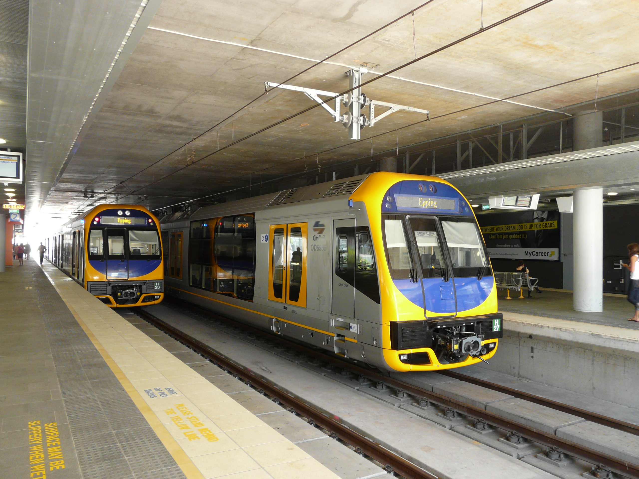
The new line was plagued by delays and cost blowouts. In one instance, community backlash over a proposed bridge over the Lane Cove River forced the line to tunnel under the river instead. The deep tunnelling did not merely increase cost and lengthen duration of construction, but resulted in the abandonment of a station at the UTS Kuring-gai campus leading to its closure in 2015. Additionally, the steep gradients on the tunnel meant that Tangara and Millenium trains were initially not used on the line, despite these being the newest suburban trains on the network at the time. Rather the interurban OSCAR trains normally reserved for long distance train journeys would be used instead when the line eventually opened.

Due to steep gradients, some trains were unable to run on the Epping to Chatswood Line when it opened. As a result, OSCARS were used as a shuttle service instead. Click to enlarge. (Source:Wikipedia.)

In 2003, the NSW Government announced that the Parramatta to Epping Rail Link (PERL) portion of the project had been deferred indefinitely. Low levels of projected patronage was given as the reason. This effectively cancelled that half of the project.

The Epping to Chatswood Line eventually opened in 2009 at a cost of $2.3bn. This compared to an initial projected opening date of 2006 and budget of $1.4bn for the entire Parramatta to Chatswood Line.

The next decade would see the PERL reannounced, cancelled, then reannounced again; most recently in 2017s Future Transport Plan 2056, placing the line on the government’s wish list. However, under the current transport strategy it may not open until the second half of the century.

Future Transport Plan 2056. Click to enlarge. (Source: Transport for NSW.)

Meanwhile, urban development of the Upper North Shore and its associated population increase has since led to a rise in demand for rail travel along the North Shore Line, eating up much of the spare capacity that was previously available. So much so that the government is about to begin construction on an extension of the Epping to Chatswood Line (as part of the new Sydney Metro) South through to the CBD in order to add additional capacity.

How it might have happened

The delays and cost blowouts made building the entire line a challenge for the then NSW Government. After all, this was not a time of huge stamp duty revenue streams and zero government debts. In order for the Parramatta to Epping Line to have been built, this was the main obstacle that needed to be overcome.

Perhaps a bit more planning and greater political strength in facing down the community backlash on issues like the Lane Cove River Bridge may have been enough to achieve this. Had this happened then the UTS Kuring-gai campus would almost certainly have survived. Or the Government may have instead chosen to borrow money to complete the project.

Either of these options would have proven politically unpopular, particularly for a government well into a third term. This at least in part explains their decision to abandon the line.

What this would have meant

Had the PERL opened in full last decade it could have significantly changed the direction of passenger flows in Sydney’s rail network. More passengers from the Parramatta area would travel East via Macquarie Park rather than Strathfield, reducing the pressure on the Western Line but increasing the pressure on the North Shore Line. Perhaps the densification of the Upper North Shore may not have happened, with the Parramatta to Epping corridor seeing this densification instead. Either way, the North Shore Line would now be dealing with trains from the Upper Northern Line and Parramatta in addition to those from the Upper North Shore Line.

Unlike the actual present, there would be less talk of the need for a new rail line linking the CBD to Parramatta (in the form of Sydney Metro West) as such a line would have already been built, albeit less directly, via Macquarie Park. However, like the present, there would still be a focus on building additional capacity into the CBD from the North, given the additional pressure on the North Shore Line and its single pair of tracks into the CBD.

So even though the Parramatta to Chatswood Rail Line was designed in part to avoid the need for it, additional rail capacity into the CBD looks to be the one constant that could not be avoided.

Alignment for the 2008 North West Metro. Click to enlarge. (Source: North West Metro Preliminary Environmental Assessment, p. 1.5)

One response would have been to build the 2008 Northwest Metro (see map above) from Castle Hill, but with a Victoria Road approach into the CBD rather than connecting it up to the existing line via Macquarie Park. This would provide additional capacity and act as a relief on the North Shore Line without requiring a deep tunnel under the Harbour, as the line would cross the Parramatta River further West at Hunters Hill.

Alternatively, the Metropolitan Rail Expansion Plan (see map below) would have seen a new line built between Sydenham and Chatswood, connecting the Epping to Chatswood Line in the North through to the East Hills Line in the South. Surface tracks would be built in the existing alignments from Chatswood to St Leonards in the North and Erskineville to Sydenham in the South, with tunnels required between St Leonards and Erskineville. This would create a completely new line from the North West and South West of Sydney through the CBD.

The 2005 Metropolitan Rail Expansion Plan. Click to enlarge. (Source:‘Fixing’ the trains in Sydney: 1855 revisited.)

In the North, UTS would not have closed down its Kuring-gai campus, given that it would now be served by a heavy rail line. However, train frequencies between Macquarie Park and the CBD would be limited without a new harbour rail crossing, leaving Macquarie Park more dependent on road based transport and constraining its potential growth.

Meanwhile, in the West, the Carlingford Line would now be part of the Parramatta to Epping Line. Therefore, the current plans for a light rail network around Parramatta by converting the Carlingford Line to light rail would not be possible. Perhaps Parramatta light rail would still occur, but as a direct line between Parramatta and Sydney Olympic Park to make up for the lack of a West Metro through those location.

Of course, all of this is hypothetical. The Parramatta to Epping Rail Line was never built as originally planned and we will never know what would have happened if it did. If you have your own take on what might have happened, feel free to leave a comment below explaining what you think would have happened or why you think things went the way they did.

The NSW government has decided to push ahead with tunnels on the NWRL (North West Rail Link) too steep to accommodate double deck trains, despite internal documents showing it would not result in any savings when it comes to building a future Harbour rail crossing. The same documents also show that when the Federal Government offered funding for a line between Parramatta and Epping such a line was so far off transport planners’ radars that they did not expect it to be built until after 2036, suggesting it was less of a priority than 3 or 4 other lines that would have been built first, one of which may be a long mooted rail line to the Northern Beaches.

The Options

Documents uncovered as part of a Sydney Morning Herald investigation into the NWRL shed some light on the process by which the new line’s design was decided upon. A report dated 24th May 2012 proposes 3 options for integrating the NWRL into Sydney’s rail network, named “Suburban”, “Rebuild”, and “Growth”. All options involve first building the SWRL (South West Rail Link), followed by the NWRL.

2014-02-02 NWRL Options

Summary of the 3 options available for integrating the NWRL into Sydney’s rail network. Click to enlarge. (Source: CBD Rail Capacity Programs Rail Futures Investigations, pp. 8-11)

The Suburban option (cost: $9.8bn) is virtually a carbon copy of the Metropolitan Rail Expansion Plan (MREP) of 2005 that would see the building of the NWRL, SWRL, and a Second Harbour Rail Crossing that would fill the missing section to link the two via Macquarie Park and the Airport with a maximum capacity of 24 double deck TPH (trains per hour), though capacity constraints on the Airport Line tunnel would appear to initially cap this at 20TPH. This option would continue to use double deck trains and could retain direct services into the CBD from the NWRL’s opening in 2019, though capacity would likely be tight until the completion of a Second Harbour Rail Crossing in 2026 through the “Metro Pitt” alignment roughly underneath Pitt St. Until this occurred, some NWRL trains would terminate at Chatswood and Upper Northern Line trains would be re-routed via the City Circle rather than across the Harbour Bridge. Once the new line was completed, all stop trains from Revesby would operate via Sydenham and continue to feed into the City Circle, allowing 20TPH to operate on the new line to South-West Sydney (from a current capacity of 12TPH).

Map of the Suburban option. Click to enlarge. (Source: CBD Rail Capacity Programs Rail Futures Investigations, p. 15)

Map of the Suburban option. A new Harbour crossing would link the NWRL to the SWRL, running double deck trains. Click to enlarge. (Source: CBD Rail Capacity Programs Rail Futures Investigations, p. 15)

The Rebuild option (cost: $10.6bn-$12.1bn) involved converting the Harbour Bridge to single deck operation, and was championed by Infrastructure NSW. Under this plan, the NWRL would operate with some or all trains terminating at Chatswood with either single or double deck trains. A new CBD line would then be constructed between Redfern and Wynyard (previously referred to as the CBD Relief Line), utilising the “Metro West” alignment roughly underneath Sussex St, to be completed by 2026. This would then be followed by converting the line across the Harbour Bridge to single deck operation, a process that would take 4 years and necessitate the closing of the City Circle between Central and Wynyard. This would allow cross-Harbour capacity to be increased to 28 single deck TPH, up from an existing 20 double deck TPH, by 2031.

Map of the Rebuild option. Click to enlarge. (Source: CBD Rail Capacity Programs Rail Futures Investigations, p. 23)

Map of the Rebuild option. The Harbour Bridge would be upgraded to operate single deck trains, with the NWRL and North Shore Lines linking up with the Inner West and Bankstown Lines as well as Hurstville Station operating single deck trains. Click to enlarge. (Source: CBD Rail Capacity Programs Rail Futures Investigations, p. 23)

The Growth option (cost: $9.9bn), ultimately selected as the preferred option by the NSW Government, involves the creation of a new single deck network via the construction of a new under the Harbour Rail Crossing. Under this option, the NWRL would be built by 2019 for initial operation with either single or double deck trains where some or all would terminate at Chatswood. A Second Harbour Crossing would then be built by 2026, creating a new line which would connect the NWRL to Hurstville and Lidcombe/Cabramatta via Bankstown running single deck trains with a maximum capacity of 30TPH. The line would initially operate at a maximum of only 20TPH due to network constraints at the outer ends of the line. However, the report suggests reaching 30TPH by extending it with a new Northern Beaches Line and by incorporating the all stops portion of the East Hills Line out to Revesby. As with the Suburban option, this would also allow 20TPH to operate to South-West Sydney.

Map of the Growth option.Click to enlarge. (Source: CBD Rail Capacity Programs Rail Futures Investigations, p. 30)

Map of the Growth option. A new Harbour crossing would connect the NWRL and a Northern Beaches Line to the Bankstown Line as well as Hurstville and Revesby Stations. The new line would operate single deck trains. Click to enlarge. (Source: CBD Rail Capacity Programs Rail Futures Investigations, p. 30)

 The rebuild option was rejected on the basis that it was the most expensive, provided the smallest increase in capacity, and imposed the greatest disruption of the three. Ironically, this was meant to be the option that avoided the “prohibitively expensive” under the Harbour rail crossing, yet it ended up being the most costly as the CBD Relief Line, with a price tag of $5bn, was not that much cheaper than a new line that continued through to Chatswood, which costs $8bn, but necessitated expensive upgrades elsewhere on the network (costing anywhere from $4.3bn to $5.8bn).

The other two options cost almost the same, and provide similar levels of increases in capacity (single deck trains carry fewer passengers per train, but can operate more trains per hour than double deck trains, so the number of passengers per hour is comparable).

Steep and narrow tunnels

The Growth option included the possibility of building the NWRL with tunnels that were compatible with existing double deck trains, at a cost of $200m. This would allow some trains on the NWRL to continue past Chatswood through to the CBD from the day the NWRL opens. However, currently there is only enough spare capacity into the CBD on the Harbour Bridge to allow 1 train through in the busiest hour of the morning peak without removing services from either the Upper Northern Line and the North Shore Line.

It has previously been speculated that a steeper gradient allowed by single deck trains would allow for a cheaper and easier construction of an under the Harbour rail crossing, with stations closer to the surface at either side of the Harbour. This in turn would be where the real savings would be made, and there is little point in spending $200m to add virtually no new capacity for the few years until the new under the Harbour crossing was completed.

However, this does not appear to be supported by the costings in the leaked report, the cost of building the Harbour crossing for double deck trains is listed as $7,940m whereas for single deck trains it is $8,055m (Source: CBD Rail Capacity Programs Rail Futures Investigations, p. 34). While it does also provide $200m in savings for the NWRL, Transport Minister Gladys Berejiklian is on the record as saying that the cost of upgrading the Epping to Chatswood Line for single deck trains is more than $200m. This means single deck trains cost more in both the NWRL and second Harbour crossing stages.

In other words, it would appear that the steeper tunnels not only do not provide any savings, but they actually cost (slightly) more!

That means there must be another reason why the government has opted to go with the Growth option for single deck trains. One possibility could be that it allows for complete ATO (automatic train operation), otherwise known as driverless trains, along with all the benefits that come with it (see: here and here). These require an independent and segregated line to operate on, and only the Growth option initially running shuttles to Chatswood provide that opportunity.

Northern Beaches Rail Line vs Parramatta to Epping Rail Link

Also contained in the report is the assumption that transport planners were operating under for the Growth option that the next line to be built after the Second Harbour Crossing would be to the Northern Beaches. This is mentioned not just in the May 2012 report, but is also included on the maps in the report. The maps are dated 4 May 2010 and show the PERL (Parramatta to Epping Rail Link) as being built at some point after 2036, then operating as an independent shuttle.

Parramatta to Chatswood Rail Link

The Parramatta to Chatswood Rail Link was originally to go from Westmead to St Leonards. Only the Eastern portion, between Epping and Chatswood, was actually constructed in 2009, leaving the Western Parramatta to Epping portion unbuilt. (Source: Historical NSW Railway Timetables)

This means that just 3 months prior to the 11 August 2010 announcement that Federal Labor would fund the PERL, the then NSW Labor government had placed it so low on its list of transport projects it planned to build that it was not only below the NWRL and second Harbour crossing, but also behind a line that has not been seriously talked about since the 1970s.

This should emphasise the importance of putting good planning first, ahead of political considerations, when it comes to creating a good transport network. Unfortunately it appears the Labor Party tends to put its ideals in the right place in supporting public transport (importantly without the rabid anti-roads ideology of The Greens), but then implements it ineffectively by doing so through the prism of politics. As seen with the proposed funding of WestConnex, it’s not a one off occurrence.

A 17km light rail line from Westmead to Macquarie Park would be the first stage of a light rail network centred on Parramatta that would support an additional 50,000 homes and 180,000 jobs by 2031 according to a proposal by Parramatta City Council. This would be followed up by a line to Castle Hill, with lines to Bankstown and Olympic Park/Rhodes as potential further extensions (zoomable street map available here). Parramatta Council has been pushing for light rail since the NSW Government dumped plans for the Parramatta to Epping Rail Link (PERL) shortly after the 2011 election. Both lines are designed to link up Parramatta to Macquarie Park.

Map of the proposed Macquarie Park and Castle Hill light rail lines. Click to enlarge. (Source: Western Sydney Light Rail Network - Part 2 Feasibility Report, pp. 4-5)

Map of the proposed Macquarie Park and Castle Hill light rail lines. Click to enlarge. (Source: Western Sydney Light Rail Network – Part 2 Feasibility Report, pp. 4-5)

The main advantage of the light rail option is the cost, coming in at $919m versus $4.4bn which was the most recent figure available for the PERL. (This works out to $54m/km, compared to $31m/km for the Dulwich Hill light rail extension or $133m/km for the CBD and South East light rail.) The study envisages trams running every 10 minutes during peak hour, with 15 minute frequencies during the off-peak. As the Castle Hill line will share track with the Macquarie Park line in the Parramatta CBD, this should result in 5 minute and 8 minute frequencies, respectively, in the core of Parramatta.

Much like the CBD and South East light rail currently about to begin construction, this new line would connect up a hospital (Westmead), a stadium (Parramatta), a CBD (Parramatta), a racecouse (Rosehill), and a university (UWS) with a frequent and high capacity transport service.

The majority of the alignment also provides for trams to run on an exclusive right of way. These include the Carlingford Line alignment, where the study finds that there is space for both light rail and the Carlingford Line (including a potential PERL in the future); the median on Kissing Point Road; and the reservation for the never built Country Road at Marsfield. In addition, work currently planned for James Ruse Drive for an overpass at Camellia would allow the light rail to travel under James Ruse Drive and avoid this busy intersection.

The Parramatta CBD portion would run mostly along Macquarie St, which is one block North of the main transport interchange centred around Parramatta Station. This could prove problematic if it makes transfers from bus/train to tram or vice versa more difficult. Alternatively, if Parramatta continues to grow, then Macquarie St could also become an extension of the existing transport interchange, catering for future growth.

A potential future network. Click to enlarge. (Source: Western Sydney Light Rail Network: Part 2 Feasibility Report, p. 6)

A potential future network. Click to enlarge. (Source: Western Sydney Light Rail Network – Part 2 Feasibility Report, p. 6)

The proposal is now in the hands of the state government, which mentioned in the Sydney Light Rail Future document that a Western Sydney light rail network centred on Parramatta is something it is considering (p. 20). This is by no means a guarantee that any of these lines, let alone the full network, will get built. But Parramatta Council has put forward the right project at the right time, and that makes the possibility of this being built some time next decade a better than 50:50 likelihood.

If this blog were voting on September 7 purely on transport issues, and had to make a choice between one of the 2 parties that will form government, then it would with reservations cast its vote for the ALP.

There are many other issues to be considered in this election, and many details as far as just transport is considered. But broadly speaking, for the upcoming election the Coalition has promised to the NSW Government more funding for transport infrastructure (albeit only for roads, not public transport) with fewer strings attached than the ALP have, while the ALP is both prepared to fund public transport and has made a slightly more solid commitment to building a much needed airport at Badgerys Creek.

Funding Commitments

Each of the major parties have made large commitments towards 3 transport infrastructure projects, all roads: the Pacific Highway upgrade on the NSW North Coast, the M2 to F3 Link in Northern Sydney, and the WestConnex freeway in Western Sydney.

The ALP has proposed 50:50 funding, shared with the NSW Government, for the Pacific Highway, which works out to $3.5bn. If the NSW Government does not match this amount then the deal is off, and there is some uncertainty over whether the NSW Government will match this amount. The Coalition has offered an 80:20 split, or $5.6bn, with the extra $2.1bn being the Parramatta to Epping Rail Link funding the ALP has previously promised (but since dropped). It is likely that the NSW Government is holding out for a possible Coalition win on September 7 before it tries to find funding for the ALP offer, but there is no guarantee that it will. If it does, then it is likely that some or most of this money will come from other parts of the transport infrastructure budget, including public transport as NSW Transport Minister Gladys Berejiklian alluded to in her bizarre comments that she welcomed news of not receiving any funding for public transport.

The M2 to F3 project is set to receive $400m of Commonwealth funding regardless of who wins next month, following a commitment by the ALP in May which was matched by the Coalition.

Map of the proposed WestConnex alignment showing it connecting to the City West Link. (Source: WestConnex – Sydney’s next motorway priority, Infrastructure NSW, p. 17)

Map of the proposed WestConnex alignment showing it connecting to the City West Link. Click to enlarge. (Source: WestConnex – Sydney’s next motorway priority, Infrastructure NSW, p. 17)

For WestConnex, the ALP is offering to match the NSW Government’s current $1.8bn contribution, while the Coalition has promised $1.5bn. Both parties have made their funding conditional on the M4 East being extended to the CBD (a poor decision, as explained here), while Labor has also required a link to Port Botany and for existing portions of freeway to remain toll free. These requirements will result in a higher construction cost and a lower cost recovery, to the point where the total cost to the NSW Government could be lower if it rejected the extra funding. While the Coalition’s offer does have fewer strings attached, both parties are guilty of this.

Overall, a Coalition Government in Canberra would likely provide more funding ($7.5bn vs $5.7bn), and do so with fewer restrictions.

Funding philosophy

Tony Abbott has consistently voiced his view that the Commonwealth Government should not fund any urban rail projects. He has been given many opportunities to elaborate on this view, and each time he has stuck to his guns on it. Often, this has been based on false assumptions. For example, he initially argued that the Commonwealth had no history of funding urban rail (which was incorrect). He then clarified by arguing that no Commonwealth Government before current Labor Government won office in 2007 had a history of funding urban rail (which was also incorrect). Melbourne based transport advocate put it best when he said perhaps the Federal Coalition has no history of funding urban rail, but the Commonwealth most certainly does.

The ALP, on the other hand, both supports the funding of public transport and has a history of doing so. While there are no current pieces of public transport infrastructure that the ALP is offering to provide funding for, such support may be essential for projects currently in the pipeline, such as the South East Light Rail or a Second Harbour Crossing.

Route of the George Street and South East Light Rail Line. Click to enlarge. (Source: Transport for NSW)

Route of the George Street and South East Light Rail Line. Click to enlarge. (Source: Transport for NSW)

Most importantly, public transport projects are much less able to obtain private sources of funding, whereas roads are able to source all (or atleast most) of their funding from user tolls. Therefore, it is the height of ridiculousness for a Commonwealth Government, the level of government with most access to revenue raising, to rule out funding the sort of infrastructure that most needs government support to go ahead and to instead focus its funding on those projects which least need it. This is particularly the case when it’s considered that rail has a capacity 10 times as large as the equivalent amount of road space used by cars.

On the issue of funding philosophy, the ALP comes out ahead.

Second Sydney airport

Neither party is yet willing to come out and state the obvious: that Western Sydney needs an airport of its own, and that Badgerys Creek is the best site for it. Even Max Moore-Wilton, head of Sydney Airport, agrees that Sydney will need a second airport and that Badgerys is the best location. The only thing he disagrees on is the timing, claiming that Sydney Airport will have sufficient capacity until 2045.

Current and proposed Sydney airports. Click to enlarge. (Source: Google Maps, modified by author)

Current and proposed Sydney airports. Click to enlarge. (Source: Google Maps, modified by author)

But none of this can allow politicians to ignore the fact that an airport in Badgerys Creek is an essential piece of infrastructure that will allow the much needed creation of jobs in Western Sydney, which will soon overtake Sydney’s Eastern half in population. Despite this, 200,000 Western Sydney residents currently commute into Eastern Sydney each day due to a jobs deficit, and this will only increase in coming decades if nothing is done about it. This in turn puts additional stress on transport infrastructure, which in turn has resulted in pressure to build projects such as WestConnex. Improvements to Kingsford-Smith Airport at Mascot will do nothing to ease this strain on jobs and infrastructure.

Transport Minister Anthony Albanese has now declared that if re-elected, he would like to see Labor Government will begin work on a second airport in its next term, but without nominating a site. Meanwhile, the Coalition has refused to nominate a site or a start date, though at the leader’s debate this past Sunday Opposition Leader Tony Abbott did promise to make a decision in his next term. Neither of these positions is ideal, although privately it looks like both parties plan to begin work soon on an airport and choose Badgerys Creek as the location. Despite this, the ALP’s commitment is slightly more concrete than the Coalition’s and Mr Albanese is a stronger advocate for Badgerys Creek than Warren Truss as Transport Minister is likely to be.

The federal Liberal Party's transport policy consists exclusively of road projects, with no committments to public transport. Click on image for higher resolution. (Source: Our Plan Real Solutions For All Australians, Liberal Party, page 32)

The federal Liberal Party’s transport policy consists exclusively of road projects, with no commitments to public transport. Click on image for higher resolution. (Source: Our Plan Real Solutions For All Australians, Liberal Party, page 32)

Opposition Leader Tony Abbott declared last week that he would be committing no funding to public transport ahead of this year’s election, despite having committed $4bn to road projects in Sydney, Melbourne, and Brisbane.

“We spoke to Infrastructure Australia and their advice was that the most pressing road priority in Melbourne was the east-west link. The Commonwealth government has a long history of funding roads. We have no history of funding urban rail and I think it’s important that we stick to our knitting, and the Commonwealth’s knitting when it comes to funding infrastructure is roads.”Tony Abbott, Federal Opposition Leader (4 April 2013)

His first point, about the highest priority road project in Melbourne, is correct because he is talking about road projects specifically rather than transport projects in general. However, according to Alan Davies at The Urbanist, the East-West Link road is only on Infrastructure Australia’s “Real Potential” stage, the second of four categories, while the Melbourne Metro rail project is in it’s top “Ready to Proceed” category. At best, Mr Abbott is asking the wrong question, at worst he is committing money to a project with a benefit cost-ratio of only 0.50 (i.e. the benefit is less than the cost), when he could be funding the Melbourne Metro with a benefit-cost ratio of 1.30 (figures from Alan Davies’ article linked to previously).

His second point, on the Commonwealth government having no history of funding urban rail, is just flat out wrong. As Daniel Bowen points out when listing just some of the urban rail projects funded by the Commonwealth, “perhaps the Federal Coalition has no history of funding urban rail, but the Commonwealth most certainly does”.

“I think all but the most car-centric person would see that in modern growing cities, you can’t move everybody around by road — that rail, particularly in inner-city areas, is much more efficient. Unfortunately unlike some of his Liberal colleagues (and unlike conservatives in such places as the UK), Tony Abbott does appear to be the most car-centric person. It comes down to this: if you want more people on public transport, provide more public transport. If you want more people on the roads, build more roads. Abbott is clearly backing the latter.”Daniel Bowen (5 April 2013)

The decision to fund road projects over rail is not a merit based decision, it is a politically based on (and one which I have criticised the Labor Party for doing in the past on both WestConnex and the Parramatta to Epping Rail Link). As a comparison, urban rail has received a majority of Infrastructure Australia funding when merit is used as the criteria.

“Fifty-five per cent of Infrastructure Australia nation-building money went to urban rail on merit.” –  Professor Peter Newman, Infrastructure Australia advisory board member (4 April 2013)

The state governments in Victoria, Queensland, and Western Australia, all governed by Mr Abbott’s Liberal-National Coalition, have also all publically voiced their opposition to his decision.

“We will continue to vigorously pursue federal government funding for this important infrastructure development.” – Denis Napthine, Victorian Premier (4 April 2013)

“Given the current Federal (Labor) Government’s support of $236 million for rail infrastructure at the Perth City Link and $3 million towards planning of the MAX light rail project, we expect that future Federal governments, whether Liberal or Labor, would consider the benefits of funding such important transport initiatives based on merit.”Colin Barnett, WA Premier (4 April 2013)

“The reality is if there is not federal funding for these projects, they cannot proceed, we cannot afford to do them alone. We’ll continue that process of lobbying the federal coalition and federal Labor.”Scott Emerson, Queensland Transport Minister (4 April 2013)

Feeling the heat, Mr Abbott later clarified his statement, pointing out that his government would still fund freight rail and interstate transport, and that it was only commuter urban rail projects that he was referring to. On his side is the division of powers set out in the Australian constitution, where the Commonwealth government is responsible for freight and interstate transport, leaving state governments responsible for urban transport. While Mr Abbott is well within his rights to follow a strict interpretation of the role of the Commonwealth government, it is also true that such a view would preclude federal funding of schools and hospitals, given that they are a state responsibility. This is why the days of health, education, and transport being funded solely by the states has now long gone.

This is where his argument starts to fall apart on constitutional grounds, and it becomes clear that it is ideologically driven. He seems much like American conservatives, who see public transport as a socialist means of transport “for the masses” requiring government subsidy while seeing the private motor vehicle as a form of transport that is liberating and free and more in line with their small government philosophy. He looks at the inner city areas which most heavily use public transport and sees Labor and Greens leaning voters, then at the car dominated outer suburban areas are where the swinging voters he needs live and decides that the politically astute thing is to build more roads.

“Public transport is generally slow, expensive, not especially reliable and still [a] hideous drain on the public purse…Mostly though…there just aren’t enough people wanting to go from a particular place to a particular destination at a particular time to justify any vehicle larger than a car, and cars need roads”Tony Abbott, Battleline, page 174 (2009)

Not all conservatives still think this way. NSW Transport Minister Gladys Berejiklian has successfully championed public transport despite opposition from Infrastructure NSW Chairman Nick Greiner and CEO Paul Broad, while London Mayor Boris Johnson is pushing an ambitious £913m expansion of his city’s bike network. They understand that you can’t build your way out of congestion with more roads and that, while roads play an important role, so does public and active transport. It’s disappointing to see that Mr Abbott hasn’t worked this out yet.

One criticism sometimes raised on the O’Farrell government’s transport policies are that all new transport projects are CBD centric. The Northwest Rail Link (NWRL) and Southwest Rail Link (SWRL) will both funnel commuters into the CBD, as will the Southeast and Inner West Light Rail Lines aswell as the Northern Beaches BRT. But what about Western Sydney? The previous Labor government, for all its shortcomings, did build the Y-Link at Harris Park that enabled the Cumberland Line and also constructed the Northwest and Southwest T-Ways, all of which were Parramatta centric rather than CBD centric.

These comments are almost always followed up by calls for the construction of some new transport line in Western Sydney, be it re-routing the NWRL via Parramatta, building the Parramatta to Epping Rail Link, or the creation of a Western Sydney Light Rail network. If resources were unlimited, then construction on all of these would begin tomorrow. But they are not, so it poses the question: given the limited transport budget, what would provide the largest benefit to Western Sydney for the smallest cost?

Current transport infrastructure in Western Sydney that is currently underutilised: the Cumberland Line in red and the bus T-Ways in blue, as well as the proposed Parramatta to Epping Rail Link in purple. Click on image for higher resolution. (Source: Open Street Map.)

Current transport infrastructure in Western Sydney that is currently underutilised: the Cumberland Line in red and the bus T-Ways in blue, as well as the proposed Parramatta to Epping Rail Link in purple. Click on image for higher resolution. (Source: Open Street Map.)

A counter-argument to this is that rather than suffering from underinvestment, Western Sydney instead suffers from poor planning. So rather than building new infrastructure  the government should instead first seek to fully utilise existing infrastructure. The Cumberland Line, for example, runs only 5 trains per day. Yet because this line branches out at Granville, about half the trains go South to Liverpool and half go West to Blacktown, there is plenty of spare capacity on it. It would be quite easy to run 2 or even 4 trains an hour in each direction on this line all day. The T-Ways, while currently providing good service with 10-15 minute frequencies all day (and as many as 20 buses during the busiest hour in the AM and PM), could easily scale this up even further. A lack of layover space for buses in Parramatta’s CBD means buses may need to be through-routed past Parramatta and end their route elsewhere, but this would also have the added benefit of providing additional direct links to Parramatta.

The main reason why this does not happen is the political benefit from it is small compared to new construction. “Government to build new rail line to XYZ” makes a great headline, whereas “Government to provide additional frequencies on existing line with spare capacity” does not. Here the O’Farrell government should learn from the Carr Government’s Clearways Program, which sought to increase the capacity of the Cityrail network by targeting bottlenecks and pinch points in the existing network, rather than increasing capacity by building new lines. It did not get the sort of headlines that the NWRL, SWRL, or WestConnex have, but it achieved the sorts of benefits of these new projects at a fraction of the cost.

NOTE: I’m not an expert on Perth’s transport network, the extent of it isn’t much beyond the one time I caught a train in Perth back in the mid 90s. So apologies if there are any inadvertent errors about the network or specific policies by either government (the ABC’s 730 WA program did a more in depth report here, for those interested). It’s more the general concept that I’m trying to comment on than the specifics of Perth itself.

WA voters go to the polls this weekend to elect their state government, and one of the major issues is public transport. Perth in particular is suffering growing pains and the failure of infrastructure to keep up has resulted in big increases in congestion. In an attempt to re-gain power, WA’s opposition Labor Party has put together a heavy rail expansion policy known as Metronet: representing 75km of new rail lines out into the outer suburbs of Perth. The Liberal government, led by Premier Colin Barnett, is proposing a single new line to the airport, light rail from inner Perth into the CBD, and improvements to the road network.

Metronet. The WA Labor Party's proposed rail expansion plan. Click on image for higher resolution. (Source: WA Labor Party.)

Metronet. The WA Labor Party’s proposed rail expansion plan. Click on image for higher resolution. (Source: WA Labor Party.)

One of the lines promised by Labor’s Metronet is the Ellenbrook Line in Perth’s North (the green line in the top right of the map). The current Liberal government actually promised to build this line during the 2008 election that put them into power, but later reneged on this promise on the basis that no work had been done on it and that the PTA (WA’s public transport agency) did not consider it a priority. Labor Leader Mark McGowan was criticised for this during the leaders’ debate (video available here, skip ahead to the 30 minute mark). This was the content of the exchange:

Geof Parry (7 News): The PTA had a look at this and there’s not the case now for a rail line to Ellenbrook. I mean, that’s PTA, not the government, saying there’s no case for it.

Mark McGowan (WA Opposition Leader): Ellenbrook is growing massively and everyone out there knows it. My colleague Rita Saffioti tells me about it everyday. But this rail line will also connect Morley up to Ellenbrook. There will be 200,000 people living there and they need decent transport.

Mr McGowan has the right conceptual framework here. Nothing competes with heavy rail when it comes to passenger capacity, and building lots of it is the most effective way of relieving congestion. But Mr Barnett has the implementation right. He promised the Ellenbrook Line from opposition, but when in government the public service informed him that it was not a line that was needed, and so he abandoned it.

Without knowing much about the details of the Ellenbrook Line it’s impossible to say for sure, but the earlier quote does make it look more like a line on a map drawn for political purposes than the conclusion of a well thought out process of how to improve Perth’s transport network. In that regard, it is quite similar to the now abandoned Parramatta to Epping Rail Link (PERL) in NSW. Here you had a line which was supported for political reasons, rather than because it fit into a big picture plan (even Infrastructure Australia rejected the PERL as “not on Infrastructure Australia’s priority list”).

The reality is that going to an election with very specific plans for what you are going to build is not the right approach. It would be like the federal opposition in 2007 promising to not only build the NBN, but providing a detailed list of where it would be rolled out to over the next decade. Those sorts of details are better left to when you get into government, with a more general view until that point.

The O’Farrell government did this well regarding light rail in the lead up to the 2011 election. It used phrases like “could expand Sydney’s light rail” rather than “will expand”, and attached the words “subject to feasibility” to the end of most of its promises (Source: page 19, NSW Voting Guide 2011). Some may have criticised this as providing themselves with a get out of jail free card. But if the alternative is dogmatically following through on an election promise which the public service have shown them to be misguided, then some wriggle room is much preferred. (It should be noted that there is a fine line between outlining your ambitions, and pretending to endorse a transport project without actually committing to it.)

In fact, the current NSW government’s backflip on the NWRL – which it promised would run double deck trains through to the city – is further evidence of the importance not to promise down to the minor details when you don’t know what will or won’t work. Politicians of all parties and in all jurisdictions would do well to remember that, and learn to say the words “subject to feasibility”.

The transport bureaucracy underwent a war of ideas last decade between supporters of single deck and double deck trains, according to one of the author’s of the Sydney Morning Herald’s 2010 Independent Public Inquiry into a Long-Term Public Transport Plan for Sydney, Sandy Thomas, in a 13 page article called ‘Fixing’ the trains in Sydney: 1855 revisited. The metro advocates would come out victorious, according to Mr Thomas, and their advice has been accepted without question by Transport Ministers since, despite only representing one side of the debate. He further laments that this could lead to a repeat of the year 1855, when different rail gauges in different parts of Australia prevented a unified rail network, but this time with narrower and steeper tunnels preventing double deck trains from ever using big chunks of the current Cityrail network.

Mr Thomas outlines the history that led up to this point, starting with the Metropolitan Rail Expansion Program of 2005, which would see the construction of the North West Rail Link (NWRL), South West Rail Link (SWRL), and a Second Harbour Crossing, as well as track amplifications from Chatswood to St Leonards and Redfern to Campbelltown. Together with some existing lines, these would form an entirely new fast and frequent line in the network comprised of longer ten-carriage trains for long distance trips through to the North West and South West Growth Centres, operating independently from the rest of the network. It would increase CBD capacity by almost a third.

Once built, all future lines would also be entirely separate, running independently, most likely with single deck metro rolling stock.

The 2005 Metropolitan Rail Expansion Plan. Click on image for higher resolution. (Source: 1855.)

The 2005 Metropolitan Rail Expansion Plan. Click on image for higher resolution. (Source: ‘Fixing’ the trains in Sydney: 1855 revisited.)

Critics of this plan included some within the Transport Department who saw Railcorp as inefficient, led on by the Rail, Tram, and Bus Union, as well as those who were motivated by what Mr Thomas describes as “playing with new train sets”. These critics found support in the NSW Treasury – from which many staff of Infrastructure NSW would be drawn from later on – who also wanted an independent line that could be operated privately instead of by Railcorp.

“the infighting, largely but not wholly hidden from public view, was by all accounts long and bitter. To this day many of the personalities involved scarcely talk to each other” – Sandy Thomas, ‘Fixing’ the trains in Sydney: 1855 revisited, page 3 (February 2013)

Together, these public servants convinced the politicians to dump the MREP and instead immediately build a new series of metro lines. Mr Thomas explains that this was done by the presenting of selective details of each plan, rather than painting the full picture, and that politicians with little to no background in transport planning accepted these half truths as fact.

“the reports of public servants and consultants whose findings turn out to be “inconvenient” can be and have been ruthlessly suppressed” – Sandy Thomas, ‘Fixing’ the trains in Sydney: 1855 revisited, page 13 (February 2013)

The first of these would be the North West Metro, which would take the existing NWRL and connect it to the CBD via Victoria Road, rather than the then still under construction Epping to Chatswood Line, in part to avoid an expensive Second Harbour Crossing. Mr Thomas points out that while this new line provided Victoria Road with a rail line, it bypassed the jobs rich corridor of Macquarie Park, Chatswood, St Leonards, and North Sydney.

This was planned to be only the first of a number of new metros, including metros to the Northern Beaches as well as under Parramatta Road and Anzac Parade. However, a lack of funds resulted in it being contracted to “CBD Metro”, going out as far as Rozelle, only to be abandoned altogether in 2009.

2007 Sydney Metros plan. Click on image for higher resolution. (Source: Wikipedia.)

The 2007 Sydney Metros plan. Click on image for higher resolution. (Source: Wikipedia.)

The government returned to something broadly resembling the MREP: the NWRL and SWRL, but replacing the Second Harbour Crossing with a “Western Express”, which would allow fast trains from Sydney’s West to continue through to Wynyard via a “City Relief Line” under the CBD. A promise of funding from the federal government also added the Parramatta to Epping Rail Link (PERL) to that list of projects. A change of government in 2011 saw the incoming O’Farrell government keep and prioritise the NWRL and SWRL, while deferring and eventually dumping the Western Express and PERL.

Meanwhile, inside the Transport for NSW, a new plan was designed to convert part of the existing network to single deck metro trains, including the existing Harbour Crossing in an attempt to avoid building a Second Harbour Crossing. This plan was leaked to the media, and consisted of the NWRL and North Shore Line to the North as well as the Inner West Line, Bankstown Line, and part of the Illawarra Line through to Hurstville (utilising a second pair of tracks between Sydenham and Hurstville).

Mr Thomas explains that this plan was prevented from getting the green light because it would be unable to handle 28 to 30 trains per hour, as previously believed, and therefore not provide the additional cross Harbour capacity that it promised. It too, would be abandoned (though while still in the planning stages), and plans for a Second Harbour Crossing were once again put back on the table.

The 2011 leaked metro conversion plan. Click on image for higher resolution. (Source: 'Fixing' the trains in Sydney: 1855 revisited.)

The 2011 leaked metro conversion plan. Click on image for higher resolution. (Source: ‘Fixing’ the trains in Sydney: 1855 revisited.)

Uncertainty remained. Mr Thomas points out that while Transport for NSW opposition to a new double deck line integrated into the Cityrail network was shared by Treasury, and now also Infrastructure NSW, that this did not extend to large scale expansion of the rail network. Instead these were “advocates of greater spending on motorways rather than public transport, including Infrastructure NSW supremos Nick Greiner and Paul Broad, [who] were actively ramping up their efforts to kill off any form of the North West Rail Link project” (Sandy Thomas, ‘Fixing’ the trains in Sydney: 1855 revisited, page 4).

As it were, Infrastructure NSW did endorse the NWRL, most likely due to pressure from the government, but opposed the construction of a Second Harbour Crossing, instead suggesting the government opt for the previously rejected metro conversion. Transport for NSW instead suggested a Second Harbour Crossing in addition to, rather than in lieu of, a metro conversion. The government sided with Transport for NSW.

The 2012 Sydney Rail Futures plan. Click on image for higher resolution. (Source: 'Fixing' the trains in Sydney: 1855 revisited.)

The 2012 Sydney’s Rail Future plan. Click on image for higher resolution. (Source: ‘Fixing’ the trains in Sydney: 1855 revisited.)

This plan, known as Sydney’s Rail Future, included a modified version of the NWRL with narrower and steeper tunnels, too small to fit existing double deck trains and too steep for them to run through even if they did fit. It is here that Mr Thomas makes not so much his main criticism, but almost a plea to the Transport Minister. His concluding remarks are replicated below in full.

“But there’s one simple step that NSW Transport Minister Gladys Berejiklian can and should take immediately: veto the lunatic attempt by her bureaucrats to quietly create a multiple “loading gauge” rail network in Sydney through the specification of unnecessarily small and steep tunnels on the North West Rail Link.

If Ms Berejiklian does this, she’ll be rightly remembered as the politician who took less than a year to unravel the loomingmess ofmultiple gauges in Sydney. In comparison, that first “expert” multiple gauge decision in Sydney, in 1855, is still creating problems around the nation 158 years on.

If she does intervene in this way, even if realpolitiks forces her in the short term to persist with Sydney’s Rail Future’s cobbled together “vision” for second-best services on the North West Rail Link, in the longer term sanity can be restored and everyone wanting to keep open a real possibility of much-needed, cost-effective improvements in all of Sydney’s rail services, instead of the cannibalisation and quiet dismantling that is now proposed, will have cause to thank her forever.” – Sandy Thomas, ‘Fixing’ the trains in Sydney: 1855 revisited, page 13 (February 2013)

The NSW Government has ignored Western Sydney and the advice of its independent advisory body, Infrastructure NSW, according to Opposition Leader John Robertson in a speech yesterday to the Rail Future Conference. He also accused the government of mismanaging those projects currently underway, pointing to cost blow-outs, choosing projects with a poor cost-benefit ratio, and lacking either a start or end date for construction.

Mr Robertson defended the previous Labor Government’s record on transport, admitting that while he is “the first to admit that the previous Labor Government made its share of mistakes” that it also had its fair share of achievements.

“The South West Rail Link – planned and construction commenced under Labor, leaving the incoming Government with little but a ribbon to cut. The creation of rail clearways – a first step towards untangling Sydney’s spaghetti of lines. Rolling stock renewal through the acquisition of 35 Millennium trains, 55 Oscars and 78 Waratahs. The Inner West Light Rail Line. The Epping-Chatswood Rail Link. Dozens of commuter car parks and easy access upgrades. The $100 million state-of-the-art bus interchange at Parramatta railway station. And an innovative new system of Metrobuses.”John Robertson, Opposition Leader (28 February 2013)

John Robertson, NSW Opposition Leader (Image: NSW Parliament)

John Robertson, NSW Opposition Leader (Image: NSW Parliament)

Many of these achievements should not be understated. Clearways sought to improve the existing network rather than just add new lines, leading to higher capacity and greater reliability. The new rolling stock listed represents a renewal of about half of Cityrail’s electric trains over a period of about a decade. Metrobuses, which introduced the concept of through-routing and certainty over all day frequency, are a fantastic addition to the Sydney transport system, and one which should be expanded. Mr Robertson failed to mention other improvements, such as the introduction of myZone – which was a (baby) step towards integrated fares, the construction of T-Ways from Parramatta to Rouse Hill and Liverpool – allowing fast and reliable bus services to and from Parramatta, or the Unsworth Review – which brought planning for bus routes under central control but established an effective way for private companies to operate them. All of these are positive, and should be remembered every time Labor’s failures (which were more than its fair share, as Mr Robertson claims) are raised.

Where Mr Robertson’s speech falls short is in providing a positive vision for transport in Sydney, it is instead a critique of the government’s policy, what he doesn’t stand for rather than what he does.

“Taxpayers are forking out $17 million a year on Infrastructure NSW – only for the Government to ignore its advice.” – John Robertson, Opposition Leader (28 February 2013)

His attack on Infrastructure NSW shows a misunderstanding of the purpose of that body. Mr Robertson compares the ignorance of Infrastructure SWN to Infrastructure Australia, who’s advice is used to fund various infrastructure projects around the country. But Infrastructure NSW is not designed to hand out funding, it is designed to attract funding, primarily from the private sector via Public Private Partnerships (PPPs). That is why its board includes members with expertise in PPPs – such as Chairman Nick Greiner or board member Max Moore-Wilton. When it comes to making policy decision on which transport project to fund, the government instead relies on Transport for NSW, as it should.

“We have a Government stubbornly committed to its flagship project, the North West Rail Link. One that has been approved outside the Infrastructure NSW process…that Mr Greiner says has a low cost-benefit ratio and is being built for political reasons.” – John Robertson, Opposition Leader (28 February 2013)

In his introduction, Mr Robertson presents transport in Sydney as a choice between differerring options. One of these options is between the North West Rail Link (NWRL) and the Parramatta to Epping Rail Link (PERL). He then all but endorses the PERL as a preferred option, while attacking the NWRL for its low cost-benefit ratio. Problematic here is that he relies on Mr Greiner’s judgement, someone who would generally prefer private road projects than public rail ones, and so would most likely also attack the PERL for the same reasons. In fact, this is exactly what Infrastructure Australia Chairman Michael Deegan did when he said that “the Parramatta-Epping rail link…is not on Infrastructure Australia’s priority list” (7 May 2012). Criticising a project for being political in nature, only to put forward an alternative that is just as, if not more political, is not convincing from a policy perspective.

“The problem with the O’Farrell Government’s transport priorities is that they’re completely at odds with Western Sydney’s emerging needs…It has ignored Western Sydney’s exponential population growth, its high car dependency and low residential density…And it has provided no new vision for Western Sydney bus routes and transitways.” – John Robertson, Opposition Leader (28 February 2013)

These words presented the best opportunity for Mr Robertson to attack the government and present a viable alternative. It is very true that the current NSW Government has very little in the way of transport improvements for Western Sydney. But instead of using this as the basis for something transformative, Mr Robertson uses it as a soap box to all but call for the construction of the PERL. Yet this falls right into the narrative of an expensive project that sucks out the capital works budget for the entire region, the very criticism aimed at the government on the NWRL, Second Harbour Crossing, WestConnex, and South East Light Rail. Not only would this project be expensive, but it fails to fit into the dispersed and low density urban form that he himself speaks of.

Frequency transport map for Sydney. The left shows all areas within 400m of public transport, while the right shows the same but only for services with 15 minute frequencies. Click on image for higher resolution. (Source: Sydney Alliance.)

But his words on a new vision on buses is where he really drops the ball. Here he could have easily have made a commitment to raise bus frequencies to 15 minutes or better all day all across Western Sydney. It would help to solve the problem he had just described: “the Sydney Alliance produced maps showing which parts of Sydney are within 400 metres walking distance of public transport…where a service comes at least every 15 minutes across the day…as soon as you start going west from Strathfield, the map looks pretty bleak”. But instead he opted to talk about the PERL, without ever actually committing to it.

This month will be the mid point between the 2011 election and 2015 election. In that time the NSW Labor Party has barely closed the gap in the polls. Mr Robertson’s speech contained some positive vision, but it was drowned out by the negativity. That is not to say that the opposition should not hold the government to account, but if it then fails to present its own vision, an alternative, then it is likely to stay in opposition for quite some time.

NSW Newspoll

Pointing out Labor’s past achievements are a good start. Now how about telling us what you will do in the future, Mr Robertson?

The idea for a Parramatta to Chatswood rail link dates back to the days of Dr John Bradfield almost 100 years ago when he recommended building a line from St Leonards to Eastwood as part of his rail expansion program. While Dr Bradfield did see the construction of the Sydney Harbour Bridge, completion of the underground CBD subway, and electrification of much of the network, much of the rest of his plans were shelved due to the onset of the Great Depression, followed shortly by the Second World War, and then the car and freeway boom of the post-war era.

It was not until the Carr government’s Action for Transport plan in 1998 when s plan to build a rail line between  Parramatta and Chatswood was seriously raised once more. The line would go from Westmead to St Leonards, using an upgraded Carlingford Line and then a tunnel between Carlingford and Chatswood. One of the major benefits of the new line would be that it would allow residents of Western Sydney to access the Lower North Shore without having to build an expensive second Harbour Crossing. In effect, it was a second Harbour Crossing, but it crossed the Harbour near Parramatta, where deep tunnels or long bridges would not be needed.

Parramatta to Chatswood Rail Link

The Parramatta to Chatswood Rail Link was originally to go from Westmead to St Leonards. Only the Eastern portion, between Epping and Chatswood, was actually constructed in 2009, leaving the Western portion unbuilt. (Source: Historical NSW Railway Timetables)

Overall, the 1998 plan was, like the more recent metro plan from 2007, to be funded by the sale of NSW’s electricity assets. When this sale was blocked by the ruling Labor Party’s state conference, many of the planned infrastructure projects were shelved with it (though not the road projects, as these were to be funded via private tolls, and were not reliant on government funding).

UPDATE: The M5 East was completed despite being funded by the government, rather than tolls. As construction on this had already started in 1998, it may have been too late to abandon it once the planned privatisations were blocked.

The Parramatta to Chatswood line was not entirely abandoned, but it was truncated to the Epping to Chatswood Rail Link, with the unbuilt portion: the Parramatta to Epping Rail Link (PERL) having been deemed to not provide sufficient patronage to justify its construction. Additionally, opposition from local residents and environmental groups meant the alignment was re-routed deeper underground so as to bypass parts of a national park. This resulted in delays, a blowout in construction costs, and the abandonment of a previously planned train station at the UTS Kuringai campus.

Parramatta to Chatswood alignments

The original Southern alignment included a station at UTS Kuringai, which was later abandoned when the deeper Northern alignment was chosen. The Dehli Road Station was retained, but moved closer to Macquarie Park. (Source: Action for Transport, NSW Government, 1998, page 18.)

By the time this new line had been completed in 2009, the state government had announced plans to build a new metro out to Rouse Hill in Northwest Sydney, then truncated it to Rozelle in Sydney’s Inner West (due to the ALP conference again preventing the sale of electricity assets which were to fund it), and would soon abandoning the metro project altogether in favour of the Northwest Rail Link (NWRL) and Southwest Rail Link.

Missing from all of these plans was the Parramatta to Epping Rail Link, until it was revived in 2010 by the Prime Minister Julia Gillard as part of an election promise to fund its construction. The Commonwealth government would contribute $2.1bn, with the state government required to fund the remainder, which was then estimated at a mere $500m. Problems soon emerged, with the cost estimated blowing out from $2.6bn to $4.4bn, meaning the NSW contribution would now be a far less affordable $2.3bn, and a change in government resulting in NSW prioritizing the NWRL over the PERL, which was quietly dumped entirely soon after.

Ironically, the NWRL vs PERL debate comes back to the question of a second Harbour Crossing. A NWRL will necessitate a second Harbour Crossing in order to meet the increased demand on the North Shore Line, while the PERL provides an alternate approach into the North Shore. However, a decade’s worth of densification of housing on the North Shore and the resulting increase in train frequencies along the North Shore Line to meet the increased demand means that the spare capacity that existed in the late 1990s no longer exists. This means that the dream of the PERL providing that second Harbour Crossing on the cheap has disappeared along with that spare capacity.

Instead the debate has moved on to providing some other sort of public transport improvement for the Parramatta to Macquarie Park corridor. Most recently the Parramatta Council has proposed light rail as a possible solution. Thus far the state government’s response has been that it will investigate the idea, but has not committed to anything further.

Three different alignments have been proposed for the Northwest Rail Link (NWRL) over the years: via Strathfield, via Chatswood, and via Parramatta.

The Options

The first (via Strathfield) involved the line from Castle Hill linking up with the Northern Line around Cheltenham on the surface, allowing trains to travel into the CBD either via Strathfield or Chatswood. This was abandoned due to the requirement that the line be quadruplicating between Epping and Cheltenham in order to prevent that portion of dual track from becoming a bottleneck. Local opposition and a cost so high that tunnelling was a cheaper option led to this alignment being abandoned in favour of the second option.

NWRL via Strathfield: The alignment goes from Castle Hill to Cheltenham and then Epping via a surface route, allowing it to get to the CBD via both Strathfield and Chatswood. Click on image for higher resolution. (Source: Wikipedia.)

The second (via Chatswood) is the currently planned alignment. It involves connecting the rail tunnels directly to the underground station at Epping, which means all NWRL trains must continue on to Chatswood and cannot divert to Strathfield. This reduces flexibility, but Cityrail’s Clearways program of sectorising the rail network into independent lines meant that flexibility wasn’t something Cityrail was looking for anyway.

NWRL via Chatswood: The alignment goes from Castle Hill to Epping via an underground tunnel, continuing to Chatswood via Macquarie Park. Click on image for higher resolution. (Source: Transport for NSW.)

The third (via Parramatta) was floated by Parramatta Council as a way of getting the Parramatta to Epping Rail Link (PERL) built. It involved building the NWRL through to Castle Hill, then sending it South to Parramatta, before going to Epping and continuing through to Chatswood and then St Leonards (avoiding the need for an expensive Second Harbour Crossing). Passengers heading into the CBD could change at Parramatta for express services. However, it also meant a longer trip for anyone heading to Macquarie Park or the North Shore.

NWRL via Parramatta: The alignment goes from Castle Hill to Parramatta and then Epping. The dotted line shows the via Strathfield alignment. Click on image for higher resolution. (Source: Channel Ten News.)

All three options see capacity constraints for CBD trips: with the Western, Northern, and North Shore Lines all highly congested and near capacity.

Where do people from The Hills want to go?

The locations that Hills residents desire to travel to is ultimately what should determine which of the 3 options should be taken. For the purpose of determining this, work commutes will be taken into account (as data is most easily available for these, though the most recent data I was able to obtain was from 2001). I’ll be using Bus Contract Region 4 (see map below) as a proxy for The Hills, however this also includes areas further South such as Westmead, Northmead, Carlingford, etc. Calculations are included at the end.

Bus contract regions map. (Source: Transport for NSW)

Most Hills residents (57% [1]) work outside of large centres. The widespread nature of where their work is located means that public transport is unlikely to compete with the private vehicle for their work commutes. Nor should it, as these are the sorts of trips which require the flexibility of a car, rather than the capacity of public transport. The remaining 43% work in large centres [A], primarily in Parramatta/Westmead – 9.9% [A], the Global Economic Arc (Macquarie Park, Chatswood, St Leonards/Crows Nest, and North Sydney) – 7.7% [B], the Sydney CBD – 7.3% [1], Castle Hill – 4.7% [A], and various other centres – 12.6% [1]. These are respectively shown in green, blue, yellow, grey, and brown in the chart below.

Note: The above diagram shows North Sydney as having a 42% jobs share. That is a typo. It should read 2.3%

Given the southern half of Region 4 includes suburbs between Parramatta and The Hills, which are likely to over represent the number of people who work in Parramatta/Westmead, the proportion of Hills residents who work in Parramatta/Westmead is likely to be less than 9.9%. That would make each of the 3 major employment zones (Parramatta/Westmead, the Global Economic Arc, and the Sydney CBD) are roughly equal in size, with Castle Hill close behind them.

How the different alignments stack up

All three options have the same alignment up to Castle Hill, at which point they begin to diverge. So it is the other 3 employment zones which differentiate the alignments.

The via Parramatta alignment is the only one that provides access to Parramatta/Westmead (the latter via a change of train at Parramatta). It also provides access to both the CBD (with a change of train at Parramatta) and the Global Economic Arc (by continuing on via the Parramatta to Epping Line). However, the former is capacity constrained and the latter would be delayed by having to travel to Parramatta before continuing to Epping.

The via Strathfield alignment gives no access to Parramatta/Westmead. By allowing some trains to go to the CBD via Strathfield and some via Chatswood, capacity constraints are limited. However, it also limits access to the Global Economic Arc. Eventually, construction of a Second Harbour Crossing can allow all trains to travel via Chatswood, providing good access to both the CBD and Global Economic Arc.

The via Chatswood alignment gives no access to Parramatta/Westmead. It gives the best access to the Global Economic Arc, initially with direct trains to Macquarie Park and Chatswood, but easily extended to St Leonards by quadruplicating the track between Chatswood and St Leonards. Eventually, construction of a Second Harbour Crossing can allow all trains to travel directly to the CBD, providing good access to both the CBD as well as the Global Economic Arc.

The via Parramatta option provides benefits if a Second Harbour Crossing does not happen, and is partly designed to defer the need for one. It also highlights why the government has committed to a Second Harbour Crossing – it unlocks much of the potential of the NWRL. This makes the via Parramatta option a viable one, but also one that suffers from short sighted vision, as a Second Harbour Crossing will eventually be needed, but will be less useful if there is no NWRL for it to connect to.

The via Strathfield and via Chatswood options seem roughly neck and neck, especially considering either can be upgraded with a Second Harbour Crossing to run trains directly to the CBD via Chatswood, providing good connections to both the Global Economic Arc and CBD. But there are 2 things that make the via Chatswood option superior. First, it avoids the problems of building the surface route between Epping and Cheltenham to avoid capacity constraints on that portion of track – including high cost of land acquisition, delays due to the need to start planning again from scratch on that portion of the line, and strong local opposition. Second, it goes against the concept of sectorisation, mixing different trains on the same lines – in particular this would prevent an effective private sector operation of the new line and the associated cost benefits that could come from it.

Conclusion

Each alignment has advantages and disadvantages, and there is no clear superior option. However, the NWRL via Chatswood alignment does appear to have a slight edge over the other options, on the assumption that a Second Harbour Crossing is built right after the NWRL is completed (as is current government policy).

However, this does not increase capacity on between the Hills to Parramatta, so improvements here should also be considered, particularly on the key Windsor Rd and Old Windsor Rd corridors. The former has a proposal for light rail linking Parramatta to Castle Hill currently undergoing a feasibility study, while the latter already has a T-Way where increased bus frequencies would easily achieve improved mobility.

Sources

[1]: Contract Region 4 (page 15)

[2]: Contract Region 7 (page 6)

[3]: Employment and Commuting in Sydney’s Centres, 1996 – 2006 (page 8)

Calculations

[A]: “Of the workforce living in Region 4 approximately 43% work in major centres. Of those employed in centres, most were employed in…the centres of Parramatta (16%), Castle Hill (11%) and Westmead (7%)” [1]

Castle Hill: 11% x 43% = 4.7%

Parramatta: 16% x 43% = 6.9%

Westmead: 7% x 43% = 3.0%

Parramatta/Westmead: 6.9% + 3.0% = 9.9%

[B] 13.2% of Region 4 workers are employed in Region 7, which includes all 4 centres of the Global Economic Arc [1]

Region 7 employs 206,500 workers in total [2]

Each of the centres in the Global Economic Arc employ the following number of workers: Macquarie Park (26,814), Chatswood (19,842), St Leonards/Crows Nest (36,514), North Sydney (36,597) [3]

Macquarie Park: 13.2% x ( 26,814 / 206,500 ) = 1.7%

Chatswood: 13.2% x (19,842 / 206,500 ) = 1.3%

St Leonards/Crows Nest: 13.2% x (36,514 / 206,500 ) = 2.3%

North Sydney: 13.2% x (36,597 / 206,500 ) = 2.3%

Global Economic Arc = 1.7% + 1.3% + 2.3% + 2.3% = 7.7%

The completed second Environmental Impact Study (EIS) for the Northwest Rail Link (NWRL) was released yesterday, and it has some further details on the project.

The Northwest Rail Link will include a new railway from Epping to Rouse Hill (green), plus a retrofitted Epping to Chatswood Line (blue). Click on image for higher resolution. (Source: NWRL EIS – Introduction, page 1-3.)

NWRL Details

The new rail line is expected to remove 14 million cars off the road each year in 2021, rising to 20 million by 2036. This 14 million cars figure compares to an earlier figure of 9 million new passengers per year in 2021, prepared by NSW Treasury in July of last year, which suggests that the patronage forecast has been increased following the addition of 2 more stations to the line (Bella Vista and Cudgegong Road) and from higher frequency, higher speed services provided by single deck compared to double deck trains.

The estimated completion date remains 2019, with tunneling to begin in 2014, then trackwork and station construction to occur between 2016 and 2018.

Construction timeline. Click on image for higher resolution. (Source: NWRL Environmental Impact Statement – Executive Summary, page 8.)

The new line will commence from the existing stub tunnels at Epping that were designed as the beginning of the Parramatta to Epping Rail Link (PERL). New stub tunnels will be built on the new line to allow for a future PERL to still be built as originally planned. This means that a future PERL will also be a single deck metro system.

No specific operating times are given, other than “early morning until late at night”, which suggests similar operating hours as the existing Cityrail network, rather than a 24/7 operation. The trains themselves are listed as having a capacity of 1,300 passengers (presumably including standing passengers), compared to the existing double deck train “crush” capacity of approximately 1,200.

The line will see an increase in maximum speeds, from the existing 80km/hour to 100km/hour, and have frequencies of 12 trains per hour during the peak and 6 trains per hour at other times, with the potential to increase frequencies to 20 trains per hour if demanded. Commuters continuing past Chatswood will need to change there for a connecting train, with peak hour frequencies increased to 20 trains an hour on the North Shore line. This means that during peak hour there will be a train every 5 minutes on the NWRL, and every 3 minutes on the North Shore Line.

Artist’s impression of the new Kellyville Station. Click on image for higher resolution. (Source: NWRL EIS – Chapter 6, p. 6-53)

4,000 new park and ride spaces will be built on selected stations, while all stations on the line (including the existing Epping to Chatswood portion) will have kiss and ride, bike storage, taxi ranks and bus interchanges. Once completed, the bus network will be redesigned to have shorter distance but frequent feeder buses into the new rail line rather than long distance buses connecting directly to the CBD or North Sydney. This had already been announced previously, and no additional specific details are available are included on what the bus network changes will be.

The new line also includes a stabling yard on the Cudgegong Road end of the line.

Unanswered Questions

The new single deck metro line from Chatswood to Rouse Hill will require a conversion of the existing line between Chatswood and Epping to be compatible with the new rolling stock. Yet missing from the EIS (or hidden away in a hard to find place) is any mention of a timetable for when this will happen. The line will presumably have to be shut down while this occurs, and this would likely happen right before the full line opens, causing a not insignificant level of disruption. So the question remains: how long will the Epping to Chatswood Line be closed?

The EIS also contains information on peak hour frequencies on the North Shore Line of 20 trains per hour. This had already been hinted at, so it is a confirmation of an open secret rather than new information. What is missing is details of what sort of off peak frequencies will exist on the North Shore Line, and how they will be organised to interface with the 6 trains per hour on the NWRL that start and end at Chatswood.

Additionally, what will happen on the Northern Line? It only has 1 track pair, yet operates both local (all stops) and express services. The inability of the express services to overtake the local services means the capacity is capped at 8 trains per hour (4 local, 4 express). In order to increase this, either the express trains must be scrapped or the tracks must be quadruplicated to allow express trains to overtake local trains. The latter is preferable, though will incur a price tag of hundreds of millions of dollars, given that the Northern Line currently shares the title of highest level of overcrowding (average passenger levels equal to 150% of seats, above the recommended maximum “crush capacity” of 135%) with the Bankstown Line. Recent reports in the Herald suggest that this option is being considered by Transport for NSW, and this was further reinforced by comments made at recent Budget Estimates hearings where it was argued that these, and other costs, have already been budgeted for.

The maximum frequency for the NWRL is quoted as being 20 trains per hour, and not 28 or 30 trains per hour as had been previously suggested in media reports. One of the purported benefits of single deck over double deck trains was the higher frequencies possible given the shorter dwell times and higher acceleration/deceleration rates of single deck trains. In fact, the Transport Minister Gladys Berejiklian has even pointed out that improved signaling technology is expected to raise the frequency of double deck trains to 24 trains per hour.

Finally, there is still no answer to the question of whether the NWRL will be a driverless system. The government’s line thus far is that they “are planning for the trains on this important rail link to have drivers”. This new phrase: “no plans” has become the new weasel word, as Sean Nichol’s explained so well in last weekend’s Herald. That is not to say that driverless trains are a bad thing, quite the contrary. But the government knows that it would face a backlash from the union were it to publically declare it was seriously considering the option. And rather than have to wait a long 7 years to demonstrate the benefits of a driverless metro, it seems to have chosen to hold off until as late into the process as it can in order to minimise union clashes.

Media reports

Bus services to go when rail link opens, Sydney Morning Herald

New rail line to slash car trips, Daily Telegraph

Noise annoys along North West Rail Link link, Daily Telegraph

North West Rail Link: Have your say, Northern District Times

North West rail station designs released, Hills Shire Times

The Transport Master Plan has highlighted a number of corridors in which it will consider either better bus connections or light rail, and in light of that it is logical to look at both as part of a larger package.

While it is the role of the heavy rail network to do the heavy lifting in Sydney’s transport network (about half of all people in Sydney live within 2km of a train station), it is designed primarily as a radial network to get people to and from the CBD. So buses and light rail serve to connect people to transport interchanges (often, but not always, a train station) as well as to provide cross city links that do not start or end in the CBD. To do this, the bus network will be redesigned (page 136), from a radial network with the CBD at the centre, to a grid network based on high frequency and transfers (for an explanation on the benefits of a network based on transfer, click on the link to Jarrett Walker’s transport blog). While this is an improvement, it does not appear to be followed with integrated fares. In other words, it should cost the same to get from A to B, regardless of what mode of transport you choose and how many transfers you make, and it does not appear that this will be the case. Instead, you will be charged extra for being inconvenienced by a forced transfer.

A hypothetical “grid” network for the Inner City bus network. Click on image for higher resolution. (Source: Herald Independent Transport Inquiry, page 315.)

The other major network wide change related to buses in the Sydney CBD. Currently most buses operate on far side terminations, travelling into and through the CBD before terminating on the other end. This is an incredibly wasteful use of CBD road space, as it requires 2 buses to use the same road: one the is dropping passengers off and a second that is picking them up. To ensure a more efficient, and therefore faster trip, buses will either through route through the CBD or begin near side terminations (page 135). Metrobuses currently do through routing, passing through the CBD and then continuing out the other end, in effect halving the number of buses required to travel through the CBD and having the added benefit of providing a cross city connection for passengers starting and ending their journey outside of the CBD. Near side terminations will involve buses terminating at an interchange either outside the CBD or on the edge of the CBD where passengers will be change to a frequent (and also faster, due to less bus congestion) vehicle that will take them to their final destination within the CBD. That vehicle could be another bus, a light rail vehicle or a train, depending on specific circumstances.

As for specific projects, the Master Plan list out a number of corridors, which are listed below in rough order of priority. In the short term, improvements will be made to existing bus services, with a longer term view to putting in place Bus Rapid Transit or Light Rail.

Northern Beaches Bus Rapid Transit

An options paper has already been released in regards to the Northern Beaches, and here it has been decided to go with BRT, rather than light rail. What hasn’t yet been decided is what sort of upgrades are to be made. All options require an upgrade of the Spit and Narabeen Bridges to 6 lanes, and include:

  1. Making bus lanes 24 hours. Cost: $336m
  2. Segregated BRT on the kerb. Cost: $488m
  3. Segregated BRT on the median. Cost: $572m
  4. Segregated BRT on the median, but with buses terminating at North Sydney rather than in Sydney CBD. Cost: $552m
  5. Segregated BRT on the median, with a tunnel under Military Road connecting the Spit Junction with the Waringah Freeway. Cost: $1.2bn

The Treasurer, Mike Baird, who’s Pittwater electorate is located in the Northern Beaches, has said that he prefers the tunnel option.

The East-West link between Dee Why and Chatswood would upgrade the bus lanes to 24 hours and cost $77m.

Transport for NSW has shortlisted 6 options for building BRT for the Northern Beaches. The currently predicted alignment is shown on this map. Click on image for higher resolution. (Source: Transport Master Plan, page 153.)

Victoria Road Bus Rapid Transit or Light Rail

Further investigation will be made into whether BRT or light rail can be used on the Victoria Road corridor between Parramatta and the CBD. (See: Transport Master Plan, pages 151 and 185.)

Light Rail in the CBD and out to UNSW/Randwick

The government’s light rail feasibility study, which is completed, has not yet been released to the public, but details of it were included in the Transport Master Plan. It suggests a new line will be a North-South line linking Circular Quay in the North to the University of NSW/Prince of Wales Hospital in the South. Options for an alignment via Oxford Street have been rejected, probably in part because this would prevent the line from connecting Central Station to Circular Quay. Light rail to Barangaroo via The Rocks and out to the University of Sydney are of lower priority. Once it is operational, bus lines that previously went into the city would be re-routed to operate as feeder services for light rail.

What has not yet been determined is whether the line will run along the surface along Devonshire Street, or if it will be built in a tunnel underneath it. The tunnel option has been rumoured to cost $100m. A tunnel would allow a faster and more reliable trip. The speed is a key factor, as it also reduced the need for additional rolling stock and staff required, thus reducing operating costs, while the increased patronage will boost fares received. The lower costs and higher revenues would, in theory, repay the additional cost of the tunnel option over time.

The option is also left open to link the Anzac Parade and Alison Road alignments via High Street along UNSW. However, given the steep gradient of High Street, I’m not sure trams would be able to operate along that alignment.

A new light rail line is expected to run between Circular Quay, down George Street to Central, along Devonshire St to the SGC and Randwick Racecourse before going South on Anzac Parade to UNSW or East along Alison Road to the Prince of Wales Hospital. Click on image for higher resolution. (Source: Transport Master Plan, page 155.)

Longer term Bus Rapid Transit corridors: M2 and Windsor Road

Over the longer term, BRT will also be considered for the M2 between Seven Hills and Macquarie Park, as well as Windsor Road between Parramatta and Castle Hill. (See: Transport Master Plan, page 185.)

Parramatta Light Rail

The Parramatta City Council has been pushing for a light rail network centred around Parramatta, in part to compensate for the lack of a Parramatta to Epping Rail Link. The Transport Master Plan acknowledges this proposal, suggesting that it will consider the recommendations of any feasibility study that the Council is able to commission. (See: Transport Master Plan, page 189.)

There are many things missing from the Draft Transport Master Plan. While defining it by what it doesn’t have, rather than what it does, would result in a never ending list, there are some major omissions that deserve some specific mention. They are, in no particular order:

Integrated fares

While integrated ticketing is being introduced with the rollout of Opal, allowing commuters to use just one ticket to get around Sydney, there is nothing in the transport plan suggesting that they will be charged an equal fare regardless of which (or how many) mode (or modes) of transport they use to reach their destination. In other words, if you are going from point A to point B, then it shouldn’t matter which way you get there, you should be charged the same fare.

At the moment Sydney does not have integrated fares. In fact, if you use 2 vehicles (unless it’s trains or you have a weekly MyZone ticket) then you are charged a premium fare despite the fact that having to make a transfer is a reduction in the quality of your journey. This has led to many anywhere to anywhere bus routes all over Sydney, as commuters refuse to pay extra to change from one bus to another, resulting in the available buses being spread thin and leading to low service frequencies.

Sydney currently has a radial bus network, as seen on the left. Proposed changes to a radial and circumferential network that emphasises transfers, as seen on the right, would improve connectivity but also require integrated fares. Click on image for higher resolution. (Source: Transport Master Plan, page 55.)

The transport plan seeks to change this model, moving to a grid (or cobweb) style network that requires transfers, but provides both frequency and connectivity. However, to work effectively, integrated fares are required to ensure that commuters are no worse off for having to transfer. This currently does not appear to be in the plan.

The Parramatta to Epping Rail Link
The O’Farrell government went to the 2011 election promising to prioritise the Northwest Rail Link (NWRL) ahead of the Parramatta to Epping Rail Link (PERL). Initially, this meant deferring the PERL until 2036, with a NWRL completed in 2019 and a Second Harbour Crossing completed some time in between. But when the Sydney’s Rail Futures plan was completed in the middle of this year it was missing any mention of the PERL, the first indication that this project had been dropped altogether.

Forward planning (unless it’s roads)

The Master Plan lists 3 new freeways that it would like built (an M4 East, an M5 East duplication, and an F3 to M2 link) plus another 3 new freeways for consideration beyond the 20 year scope of the plan (an F6 linking Waterfall to the airport, an Inner West Bypass between the M4 East and M5 East, and a freeway linking the M4 East to the M2). It then also recommends that the government begin planning reserving land in outer suburban areas so that freeways can be built there many decades into the future. This is fantastic forward planning, and should be commended as it will avoid huge tunneling costs in the future that we are contemplating today.

The transport plan has recommended reserving corridors for future roads, but does not include a similar recommendation for reserving corridors for future rail lines. Click on image for higher resolution. (Source: Transport Master Plan, page 140.)

And yet when it comes to public transport, no such recommendations are made. Where is the action on reserving land for future rail lines, light rail corridors, bus rapid transit, etc? This included in the 20 year rail plan, so why is it missing from the transport plan? Why has it been removed?

It’s hard to imagine a transport plan since the height of the automobiles golden age back in the 1950s that has felt so biased towards roads and away from public transport. Previous plans have ended up seeing more roads built than public transport, but at least they made an effort at planning for public transport before abandoning those plans. This one just skips that step entirely!

UPDATE (9 September 2012): Some further reading reveals that planning has been included for reserving corridors for both roads and public transport. The following diagram illustrates the locations of the corridors. The report, at 370 pages, was quite long and limited time meant I was unable to go through it in as much detail in the days following its release and I unfortunately missed this.

Transport corridors, both road and public transport, that are being investigated or reserved for future transport infrastructure projects. Click on image for higher resolution. (Source: Transport Master Plan, page 197.)

Funding and costings

There are some details on this, but it tends to be broad statements with some token details around the edges. For example, costings for individual projects are not included, although a figure of $100 billion over the next 20 years has been mentioned in the media. If this is accurate, then it is actually within the scope of the existing transport capital expenditure budget, which is equal to $25 billion over the next 4 years (Transport Master Plan, page 323), or roughly $125 billion over the next 20 years with some simple estimation.

The report has some interesting ideas. These include: increasing parking levies inside activity centres to discourage car use while funding public transport, reforming car registration to take into account road use (code for km based fees, rather than a flat fee regardless of how much you use the road), reforming public transport agencies (e.g. the creation of Transport for NSW, franchising Sydney Ferries, and splitting Railcorp into Sydney Trains and NSW Trains), allowing more commercial sites into existing transport interchanges, and capturing value created from transport investment. The last one is probably the one with the greatest scope to raise additional revenues, and one that I have written about previously.

However, other than these few points (not many for a plan this big), details on funding and costing remain general in nature and are lacking in specific details, examples or case studies much beyond saying “we will investigate this further”.

Light rail to Sydney University or to Barangaroo

Although the government has not decided what it will do with the results of the Light Rail Feasibility Study yet, the study has been completed, and this is evident by inclusion of details of light rail in the Master Plan. It suggests light rail for George Street in the CBD and a line on or under Devonshire St that then goes along Anzac Parade to UNSW. But gone is any mention of light rail to the University of Sydney or, more importantly, to Barangaroo. It is true that Barangaroo will have a new walkway to connect it quickly with Wynyard Station, and that it will sport a new ferry wharf. But it will be intriguing to see why the decision has been made to not extend the light rail line through to Barangaroo via The Rocks.

Bus priority

This has been talked about ever since the Unsworth Review into buses back in 2004. With most buses now equiped with GPS tracking teachnology, it is possible to work out when a aprticular bus is running late. In order to get that bus back on time, priority can be given to it at traffic lights, giving that bus a green light earlier than would normally happen. To ensure buses don’t run earlier than the timetable, this would only happen when a bus is late. This would be a huge improvement in reliability for Sydney’s bus network, and it’s unfortunate to see that little progress has been made in the last decade on implementing this.

Congestion charging

This has been ruled out by the government, despite such measures having worked well in places like London or Singapore. The idea behind it is that by charging road users a premium to use CBD roads during peak hours it will encourage some car users to travel at other times or to take public transport, thus giving those who do pay a faster trip with less traffic. It would also help to fund public transport. Instead, we have a situation where it is free to use surface streets which causes noise and pollution as well as danger for pedestrians (remember that 93% of CBD trips are on foot). Meanwhile, if you want to use the Eastern Distributor or Cross City Tunnel, you are charged. It really should be the other way around.

However, the government is looking at raising the parking levy, a tax on parking spaces in the city (I think it only applies to off-street parking). This would be a bit like a congestion charge, but would only discourage trips by people travelling into the CBD, while doing nothing to discourage trips through the CBD. And it is the latter that should be discouraged the most, as it congestion caused by people who aren’t even going into the CBD.

A second Sydney airport

The Premier Barry O’Farrell has made a strong stand on this. He doesn’t want a second airport in Sydney, and is not planning for one. This is a bit like when the Wran Government sold off land intended for the M4 East in an attempt to prevent the construction of that freeway. And while this seems to have delayed its construction, now we find ourselves with a government looking to pay $10-$15 billion to build that freeway in an underground tunnel instead, which has the effect of sucking funds away from public transport projects. Similarly, not planning for a second airport will not remove the need for one, it will only increase the problems and costs of one when it is eventually built.

Project priority and a timetable for completion

Some idea of priority is given in terms of whether a project is short term (0-5 years), medium term (5-10 years) or long term (10-20 years) in nature. But this is quite vague, and only applies to some projects. Road projects in particular, have no sense of priority at all, and await Infrastructure NSW’s report before some idea of which order they will be built in will happen.

A story by Nine News on Sunday reports that the Northwest Rail Link (NWRL) will result in longer trips into the city for some commuters. In particular, it singles out Baulkham Hills, which will see journey lengths increase by 20 minutes. This is because bus services into the city will cease once the NWRL is completed, instead becoming feeder routes that direct commuters to the new rail line. In the case of Baulkham Hills, this means catching a bus away from the city in order to catch a train into the city, resulting in the 20 minute delay quoted.

When taken in isolation, this seems highly illogical. It’s a step backwards, and an expensive one at that considering the $8.5bn price tag of the NWRL. But a bit of digging deeper, and some looking at the bigger picture, shows that there’s more to it than what was reported in the story.

SIDENOTE: Ordinarily, a lot of transport enthusiasts tend to actually be a technology enthusiast (light rail and bicycles in particular) who will push their preferred mode of transport, regardless of whether it is appropriate or not. I have previously said that BRT or light rail could be a sufficient solution to the Parramatta to Epping Rail Link corridor (here and here), given that heavy rail appears to have dropped off the radar. In this case, I am going to do the opposite: argue that buses are not enough, and that this transport corridor really does require rail. Jarrett Walker wrote an excellent piece on modal bias, which I encourage you to read if you want to know more about this concept.

North West Rail Link Map

Map of the Northwest Rail Link. Click on image for higher resolution. (Source: http://www.northwestrail.com.au)

Firstly, direct buses into the city are planned to be scrapped. Transport for NSW announced in December 2011 that this would remove almost 160 buses from the CBD each morning peak. The CBD is already so heavily congested with buses so slow that it is literally faster to get out and walk. Population growth over the next decade means this problem will only get worse. Back in 2009, when I used to live in Northwest Sydney and get the M2 bus into the city, it wasn’t uncommon to spend 10 minutes waiting for the bus to get from the Southern end of the Harbour Bridge to the bus stop at Wynyard before you could get off. This is an important point, and one I will return to.

The other major problem with the story is that it appears to have gone out looking for a route from a specific origin to a specific destination, that would result in the biggest disruption. A different trip could have shown a significant time saving. Not only that, but it is also very CBD centric, and while half of all NWRL trips have the CBD as a destination, the other half do not. Many commuters will be getting off before North Sydney, at Macquarie Park, St Leonards, or even go in the other direction towards Norwest Business Park. For example, a one way Rouse Hill to St Leonards journey would be cut from 87 minutes down to 45 minutes. This is because for most non-CBD trips, the NWRL will provide a much better connection than buses currently do.

Ultimately, it all boils down to the one major benefit that rail has over buses: capacity. While frequency and speed may indeed be better for commuters if they are served by buses rather than rail, at some point buses can only take so much capacity before the entire system becomes so congested that travel times skyrocket and delays become regular occurences. This point has already been reached, which is why the NWRL is needed. And if the NWRL isn’t built, then the delays caused by bus traffic congestion will mean that for those few routes that are predicted to have “faster bus trips”, it will never happen anyway.

If you needed any proof that the Transport Masterplan is about to be released, then it’s that key parts of it have begun to be leaked to the media. The newest details focus on the role that new roads will play Sydney’s future.

The O’Farrell government went to the last elections promising to build either the M4 East, M5 East, or M2-F3 link. its decision would be based on a report they commissioned with Infrastructure NSW that is set to be finalised in the next month. Importantly, the government only planned to build one of the three. However, the new Transport Masterplan is said to not only include all 3 of these freeways, but an additional freeway: the M6 to link Waterfall in Sydney’s South to the CBD by linking up to the M5 East near the Airport, with an estimated price tag of $10 billion.

M4 East and PERL

The proposed M4 East and Parramatta to Epping Rail Link are seen highlighted in red, along with the F3-M2 Link. Click on image for higher resolution. (Source: Transport for NSW Submission to Infrastructure Australia, August 2010)

Meanwhile, the Parramatta to Epping Rail Link has been dropped, but no additional heavy rail line (such as a Northern Beaches Line, or a rail line following a Parramatta Road, Victoria Road or Anzac Parade alignment) has been proposed in its place. In effect, the plan appears to be recommending more roads be built than was previously planned, while building fewer rail lines than was previously planned.

Action for Public Transport

Action for Transport plan from 1998. New roads are fluoro green, while new rail lines are red. The pink lines are bus T-Ways. (Source: NSW Government)

Compare this to the Carr Government’s 1998 Action for Transport plan, which proposed 5 new freeways (Eastern Distributor, M7, M2, Lane Cove Tunnel, Cross City Tunnel) and 8 heavy rail lines (Parramatta to Chatswood, Bondi Beach extension, Northwest, Airport, Strathfield to Hurstville, Glenfield Y-Link, Central Coast fast rail, Wollongong fast rail). While all 5 roads were built, only 1.5 of the rail lines were built: the Airport Line, and the Epping to Chatswood portion of the proposed Parramatta to Chatswood Line.

In both cases, rail underachieved in comparison to what was planned, while roads either met expectations (in the 1998 plan) or look to exceed expectations (in the current plan). Then again, this is all based on speculation from leaks of a report that is due to be released very shortly, so perhaps it’s better to reserve judgement until it’s made public.

At the Liberal Party Conference on 30 June, Opposition Leader Tony Abbott declared that a Liberal Government would commit $4bn to road projects in Sydney, Melbourne and Brisbane. For Sydney, this translated to $1.5bn for the M4 East.

“Almost nothing builds confidence more than seeing cranes over our cities and almost nothing signifies progress more than new roads.”Tony Abbott (30 June 2012), Leader of the Opposition

This decision was clearly made on political criteria, rather than planning and transport criteria. It funds the projects where the benefit flows primarily to the marginal electorates, rather than where the the benefit is greatest. And unfortunately, it’s a bipartisan pattern that is emerging in Commonwealth-State infrastructure funding, with the Gillard Government making a similar mistake when it declared that it would provide $2.1bn of funding towards the Parramatta to Epping Rail Link (PERL) prior to the 2010 election.

M4 East and PERL

The proposed M4 East and Parramatta to Epping Rail Link are seen highlighted in red, along with the F3-M2 Link. Click on image for higher resolution. (Source: NSW Transport Department submission to Infrastructure Australia, August 2010)

In that case, Julia Gillard at least consulted with the state government first and got them to fast track the PERL. But Mr Abbott hasn’t done this prior to his announcement, and the NSW Government currently appears to be planning to build the M5 East duplication and F3-M2 Link rather than the M4 East.

M5 East and NWRL

The NSW Government’s priority road and rail projects are the M5 East and Northwest Rail Link, both seen highlighted in red. Click on image for higher resolution. (Source: NSW Transport Department submission to Infrastructure Australia, August 2010.)

The other problem with Mr Abbott’s offer is that it represents only a fraction of the total cost. While the majority of the cost of the PERL ($2.6bn at first, though later blowing out to $4.5bn) would be borne by the Commonwealth, the M4 East has a price tag of between $5bn (for a short route between Strathfield and Ashfield) and $10bn (for the long route that also links it to the airport at Mascot). This leaves the state government out of pocket by $3.5bn-$8.5bn, compared to $0.5bn-$1.9bn for the PERL.

In both cases the problem remains that the Australian government seems to want to pick the infrastructure that the state should build, rather than trying to fit it into the long term metropolitan plan the state has developed for the city. The ridiculousness of Federal Labor insisting on funding the PERL over the NSW State Government’s preferred Northwest Rail Link (NWRL) can be seen in comments by Infrastructure Australia in which it declares that the  PERL is an inferior choice than NWRL (its concerns surrounding the NWRL aside).

Mr Abbott’s proposal in particular is concerning in that it reverts to the view that transport funding should favour road over rail, private transport over public transport. It fits in with the liberal view of individual liberty and freedom – and the private motor car provides this much better than a centrally planned public transport system designed “for the people”.  In his book, he dismisses the need for any vehicle larger than a car:

“…there just aren’t enough people wanting to go from a particular place to a particular destination at a particular time to justify any vehicle larger than a car, and cars need roads.”Tony Abbott (Battlelines, p. 174), Leader of the Opposition

The NSW Liberal Government takes a different perspective on the role of public transport, having not only made the NWRL its centrepiece but also buying the monorail and light rail, reverting them from private to public ownership (albeit still privately operated). They’ve done this presumably out of a realisation that roads do not have the capacity of public transport, and that congestion is costing the economy in potential output.

When it comes to a second airport for Sydney, the 3 most powerful Liberals from Sydney: Mr Abbott, Shadow Treaurer Joe Hockey and Shadow Cabinet Minister Malcolm Turnbull all support a second airport in the Sydney basin. Only Mr Hockey has named a preferred site so far: Wilton. None seem to be pushing for Badgeries Creek. However, Nationals Leader Warren Truss, who is also the Shadow Transport Minister, doesn’t think Sydney needs a second airport, putting him in NSW Premier Barry O’Farrell’s camp. Should Mr Truss hold on to that portfolio in government, then it seems unlikely that Sydney will see a second airport while he and Mr O’Farrell control the levers of power.

The Federal Coalition also supports completing the construction of the Pacific Highway. The completion of this project is currently uncertain as the NSW government insists that funding continue to follow the 80%-20% split where the federal government contributes the majority of the funds, while the federal government is insisting that past 2014 all federal funding would only match state dollars. Mr Truss has mentioned he would consider the suggestion by NSW to transfer the $2.1bn earmarked for the the PERL towards the Pacific Highway, which would cover the shortfall. This again suggests an anti-rail bias by the federal Coalition.

Warning: This post contains lots of statistics and graphs. If this is the sort of thing you are into, then may I recommend the blog Charting Transport.

The NSW Bureau of Transport Statistics does 30 year forecasts of transport within the Sydney Metropolitan area every 5 years. The most recent are for 2006-36, based on the 2006 census results (the transport results of the 2011 census have not yet been released), and give an insight into how we are likely to get around. I’ll be looking more specifically at the Sydney statistical division figures, which exclude Newcastle but include the Illawarra.

This post looks only at all day transport, not peak hour. Ferries do not appear to be included.

The assumptions on which it is based have already changed slightly, with a Second Harbour Crossing now expected to be built instead of the Parramatta to Epping Rail Link, so these figures probably underestimate rail’s proportion of trips to be undertaken. But otherwise the assumptions seem fairly sound.

Number of trips

In 2006 there were 16,175,000 trips on an average weekday. Just over 8 million of these were trips made by the driver of a car (50.1% of all trips). Most other trips were either car passengers (20.7%) or made on foot (19.1%), each accounting for just over 3 million trips. The remaining 1.6 million trips were split fairly evenly between rail (4.5%) and bus (4.1%). Taxis, bikes and light rail made up a tiny 203,000 trips (1.2%).

All are expected to grow over the subsequent 30 years, and by 2036 there are projected to be 22,160,000 trips per day, an increase of 6 million or 37% on 2006. The proportions are expected to remain roughly the same as in 2006, so the increases are also roughly in line with their share of trips in 2006. Looking just at the increase in trips, there will be an additional 3.3 million by car drivers (56.4% of the increase in trips), 1.0 million by car passengers (16.8%), 0.9 million walking (15.6%), 349,000 on trains (5.9%), 234,000 on buses (4.0%) and 79,000 on taxis/bike/light rail (1.4%). The disproportionate increases are in car drivers, rail and light rail.

Note: The first 3 modes of transport (car driver, car passenger and walking) are so dominant, accounting for 90% of all trips, that a second graph is included below showing just the other modes of transport so that they can more easily be read.

As mentioned previously, when looking at proportional increases, car driver, rail and light rail modes are projected to see the biggest increases. Light rail sees such a large proportionate increase (521%) that it’s included in a separate graph. This is due to the relatively small size of the current light rail network, which here is assumed to grow to include the Dulwich Hill (by 2016) and CBD (by 2021) extensions. It does not appear to factor in its inclusion in the myZone system, nor possible extensions to the Universities of Sydney and NSW. So it is quite possible that growth could be even higher. However, it should be stressed again that this increase is from a very low base.

Other modes of transport are expected to mostly see a steady increase in number of trips, with the exception of rail and bus. Rail growth picks up steam over time, with the strongest growth occurring in the 2020s once the Northwest Rail Link (NWRL) and Parramatta to Epping Rail Link (PERL) are completed. Although the PERL looks unlikely to be built to that timetable, the additional capacity from a Second Harbour Crossing is likely to have a similar if not larger effect on rail patronage during that period. Ultimately, rail trips are projected to grow by 48%.

This, together with expansions to the light rail network in the late 2010s means that growth of trips by bus grows rapidly at first while light rail and heavy rail infrastructure is being constructed, then slows once it comes online, growing by 35% over the 30 year period. This will be most obvious on the M2, where the government is expected to remove many bus services once the NWRL is completed, and the CBD, where bus lines are likely to be rerouted to become feeders for light rail rather than travel through the CBD itself.

The other large increase is car driver trips, which grow by41%. All other modes are projected to increase by between 28% and 37%.

Distance of trips

Just looking at the number of trips can be misleading. For example, although rail and bus have a fairly even share of trips, rail trips tend to be much longer than bus trips. Similarly, walking tends to be for fairly short trips.

In 2006, the longest average trip was a rail trip of 24.4km, expected to rise 14% to 27.6km in 2036.

The average length trip on cars, buses and taxis tend to be in the middle of the pack. Car drivers travelled 9.7km and car passengers travelled 7.6km in 2006, with both projected to drop 7% to 9.0km and 7.0km by 2036. Trips on buses, 8.5km in 2006, are projected to increase by 7% to 9.1km by 2036. Meanwhile, taxi trips averaged 6.3km in 2006 and are projected to fall slightly to 6.0km by 2036.

Short trips tended to be on foot (0.9km) or bicycle (3.1km), and their average distance is not expected to change much between 2006 and 2036.

Note on light rail: The data says that the average trip for light rail was 18.2km in 2006, rising to 22.6km in 2036, which seems unusual given that the current line is only 7km long, and even when the extension is completed will still be only roughly twice that distance. It might have something to do with the statistical methodology, which looks at distance by “main mode”. 

Putting the average trip distance together with the number of trips gives us the total number of passenger kilometres travelled on the average workday.

In 2006, residents of Sydney travelled a total of 131 million km on an average workday. Here again we see cars travel dominating travel, car drivers travelled 78 million km (59.5% of all passenger km) while car passengers travelled 25 million km (19.3%). Next biggest is rail, with just under 18 million km (13.6%), then bus travel with 5.6 million km (4.3%), and walking with 2.7 million km (2.1%). The remaining 1.0 million km (0.7%) were shared by light rail/taxis/bikes.

By 2036 it is projected that Sydney residents will travel 177 million km, an increase of 46 million km or 35% on 2006. This increase is driven mostly by car drivers, with an additional 24 million km (53.0% of the increase), followed by rail with 12 million km (26.9%), car passengers with 5.2 million km (11.3%), and buses with 2.5 million trips (5.5%). The remaining 1.5 million km (3.3%) were shared by light rail/taxis/bikes/walking.

Note: Similarly to before, as the car driver category is so dominant, accounting for 60% of all trips, a second graph is included below showing just the other modes of transport so that they can more easily be read.

When measuring the proportional increase in total passenger km, it is the public transport modes that have the biggest increases: light rail, rail and buses. As was the case previously, light rail’s increase is off such a low base that it is on a completely different scale to the increase in all other modes of transport, and so is included in a separate graph. Light rail km are projected to increase 670% between 2006 and 2036.

The dramatic increase in rail usage is clearly seen here. Other than light rail, it is projected to see the biggest proportionate increase in both number of trips (by 48%) and average distance of each trip (by 14%), resulting in a huge 69% increase in total passenger km. Total bus passenger km also see a modest increase, rising 45% between 2006 and 2036.

Other modes of transport are projected to see an increase in passenger km of between 20% and 31%.

Conclusion

If the end goal is to increase public transport (buses, trains, light rail) and active transport (walking, bicycles), then these projections show how much of a challenge that is. The proportion of trips on public and active transport are projected to fall from 28.3% to 27.8%, though this appears to be due to an increase in short distance car trips. However, even when looking at total passenger km, that proportion still only increases from 20.2% to 24.1%.

Meanwhile, total car km are projected to increase by 31%, meaning that an additional 31% of roadspace will be needed to keep up. Alternatively, existing roadspace could be used more efficiently via decentralisation and/or congestion tolling to encourage a more even distribution of traffic, both over time and over space.

Ideally an increase in public transport and active transport use would allow a static car km statistic, meaning less stress on our road system. And lets not forget that this is all a bit of a chicken and egg exercise. Bureaucrats predict increasing car usage and call for more roads to handle the additional traffic. New roads result in an induced demand for people to drive rather than taking public transport. The forecasts become a self-fulfilling prophecy, and meanwhile the additional traffic mean a return to the congestion that the new roads were meant to eliminate.

The announcement of a stand alone Northwest Rail Link, followed up with a Second Harbour Crossing, has been criticised as a broken promise by the O’Farrell Government. What has received less attention is the unanswered questions that this announcement leaves. It’s important to remember that the main reason why Infrastructure Australia refused to back funding for the NWRL was a number of unanswered questions in the submission by the NSW government.

  • Will the NWRL use driverless trains?
This question was raised earlier and hosed down by Transport Minister Gladys Berejiklian, who said she planned for trains on the NWRL “to have drivers”. But given the recent back flips this question deserves to be asked again, particularly considering the NSW Auditor General recently found drivers spend only one third of their time actually driving trains. Perhaps the government only intends to introduce ATO (Automatic Train Operation) and ATP (Automatic Train Protection), then running trains on “auto-pilot” but with a staffed train so that someone can take over if need be (as is the case on all commercial airlines these day). This could allow one person to act as driver and guard, as is the case in London or Singapore (which have automatically operated trains, but maintain someone on board to open/close doors and take over for manual operation if needed).
  • Will the NWRL tunnels be big enough for double deck trains, or only big enough for single deck trains?
Smaller tunnels would probably end up being cheaper, but would also further isolate the new metro portion of the network by preventing double deck trains from using it.
  • What happened to the Parramatta to Epping Rail Link?
Previous reports suggested that this had been deferred to 2036, but would still eventually be built. This new announcement makes no mention of the PERL. Perhaps it has been abandoned altogether due to the high price of a Second Harbour Crossing (costed at $10bn by industry experts). If it has, then will there be an alternative transport connection built to connect Parramatta to Macquarie Park (such as light rail or bus rapid transit).
  • Why isn’t the Inner West Line being included in the future metro network South of the Harbour?
Previous incarnations of this plan (here and here) did include the Inner West Line as a metro line. The high density housing along this line, along with stations spaced quite close to each other and the potential to separate this line from the rest of the network made it a good candidate for conversion to metro.
  • How will the Northern Line operate?
It is clear that trains will no longer go from Hornsby to the City via Macquarie Park anymore, and there have also been reports that Northern Line trains will go to Sydney Terminal at Central Station rather than going through the City and then across the Harbour. But the Northern Line is mostly dual track, meaning express trains have trouble overtaking slower local trains that stop all stations. This makes it difficult to increase services on the Northern Line. Yet increasing capacity on this line would alleviate much of the pressure from passengers on the NWRL, who would then have the option of changing either at Epping or Chatswood for CBD journeys.
  • Will there be a reduction in M2 buses before a Second Harbour Crossing is built?
The government had previously planned for a 66% reduction in M2 buses from the Northwest into the CBD once the NWRL opened, but that was when the NWRL would connect directly into the CBD itself. This seems to boil down to a question of where to put the congestion: trains from the North Shore into the City (which are at 110% of capacity) or buses from the M2 in the Sydney CBD (which is currently overflowing with buses coming across the Harbour Bridge).
  • Will the Richmond Line be attached to the Cumberland Line?
This has also been raised in the media as a possibility, yet speculation was not confirmed nor denied in the government’s recent announcement. Will trains from Richmond now run South towards Liverpool rather than East into the City?
  • Will quadruplication of track between St Leonards and Chatswood be fast tracked?

Of the proposed link between Chatswood and the CBD, this portion is the quickest, cheapest and easiest to complete given that it is short, above ground and requires little or no land acquisitions. It also connects directly to the terminus of the proposed metro line, extending it to St Leonards, which should also go some way to reducing the strain on capacity that will be caused on city bound North Shore Line trains.

Gladys fixing the trains

Unanswered questions remain for the Transport Minister. (Source: Sydney Morning Herald)

None of this takes into account the Second Harbour Crossing. Ms Berejiklian has refused to discuss details on that, saying that not enough work has been done on it to comment on the timetable or cost. Yet one thing that does seem to be clear is that this crossing will be under the Harbour, and thus result in a very expensive crossing. So there is one more question that must be asked:
  • Will all options for a Second Harbour Crossing be explored?

New track could be hung underneath the Bridge. Alternatively, the Easternmost lanes on the Bridge could be converted to rail, as they were when the Sydney Harbour Bridge opened, and a new road tunnel built under the Harbour (more cheaply than a rail one) to maintain roadspace for private vehicles. A new underground rail tunnel is surely not the only option, although it probably is the most expensive one and therefore most likely to either be cancelled/deferred or to suck the oxygen out for many other infrastructure projects.

NSW Opposition Leader John Robertson has called on the NSW Government to build both the Northwest Rail Link (NWRL) and Parramatta to Epping Rail Link (PERL), arguing that it doesn’t have to be one or the other and that federal government funding means it could build the PERL for only $520m while the Commonwealth contributes $2.1bn.

NWRL vs PERL

Labor wants both the Parramatta to Epping Rail Link (red) and the Northwest Rail Link (black) to be built. The proposed NWRL alignment has been slightly modified since this map was published last year. (Source: Sydney Morning Herald)

The reality is not quite as simple. Mr Robertson is using outdated figures, as the $2.6bn cost for the PERL has since blown out to $4.4bn. This means that the state government’s contribution wouldn’t be the affordable $520m quoted, but more than 4 times that: $2.3bn. This could just about pay to build all the light rail projects currently being considered by the government. And while the federal government has committed cash to the PERL while denying funding to the NWRL, the head of Infrastructure Australia has pointed out that the NWRL is a higher priority than the PERL.

Based on that, the chances of both rail lines being build together seem slim to nil.