Posts Tagged ‘Second Sydney airport’

VIDEO: Sydney Metro Means: This Engineering Life, Transport for NSW (2 November 2017)

It was a simple plan: create a new government agency to oversee a top down plan for Sydney’s future infrastructure needs as a city, bringing together various departments that had previously operated in isolated silos. To give it legitimacy, appoint someone with good political connections and relevant government experience. Though this might sound a lot like Lucy Turnbull and the Greater Sydney Commission (GSC), it’s actually a description of Nick Greiner and Infrastructure NSW (iNSW).

However, iNSW’s fate seems to have been isolation and subservience given that its 2012 infrastructure plan famously clashed with the Transport for NSW (TfNSW) transport plan. Ultimately, this ended with the then state government opting for the TfNSW plan and Mr Greiner stepping down. Despite this, the GSC appears to be faring much better.

It does raise the question of if adding a 2nd agency to manage Sydney’s infrastructure was unsuccessful, whether adding a 3rd is a step in the right direction. So far, the GSC’s tendency to cooperate with existing departments at the state and federal level could explain its success and provide support for retaining it going forward. Indeed, the Greater Sydney Commission’s plan, the Metropolis of Three Cities, was released in late 2017 and does not differ much from Transport for NSW’s plan, the recently released Future Transport 2056.

Metropolis of Three Cities. Click to enlarge. (Source: Greater Sydney Commission.)

As the Greater Sydney Commission’s plan has been in the public domain for longer, the remainder of this post will focus more on that plan, but in the context of the recently released Transport for NSW plan.

The Greater Sydney Commission plan curiously looks to the past, revisiting the concept of a polycentric city from the 2005 City of Cities Metropolitan Plan. This concept simultaneously rejects the idea of continuing to centralise solely in the Sydney CBD or to continue to decentralise out into the suburbs. Instead, it is a hybrid solution of focusing on Sydney’s various activity centres. The main three, the Sydney CBD; Parramatta; and future aerotropolis at Badgerys Creek, are the most prominent and form the basis of the 3 cities proposal. But it also includes many suburban centres such as Bondi Junction, Castle Hill, or Liverpool.

The release of the Future Transport 2056 plan earlier this week appears to further reinforce this idea of looking backwards, with train lines from Bondi Junction to Bondi Beach or from Parramatta to Epping that had been abandoned for years making their way out of their graves, almost zombie-like, back into an official Government transport policy document. Whether these are serious considerations, a desire to regularly revisit old ideas in the hope that the facts on the ground have changed sufficiently to make them viable, or merely a cynical exercise at promising new infrastructure so far out into the future that few will even remember it when it doesn’t end up happening won’t be known for quite some time.

Future Transport Plan 2056. Click to enlarge. (Source: Transport for NSW.)


However, the Greater Sydney Commission plan looks to the future through the addition of that extra major centre: the aerotropolis at Badgerys Creek. Prior plans for Sydney included a major urban centre in the Sydney CBD and a secondary centre at Parramatta. The Western Sydney aerotropolis will likely mirror Parramatta in size, though both will continue to be dwarfed by the Sydney CBD.

This focus on 3 cities, each with their own major urban centre at their heart, is reflected by how transport would be organised around it. Unlike other transport plans from the previous 2 decades, this new plan includes an expansion of the high capacity rail network to create orbital rather than radial lines. In other words, new rail lines that do not reach the Sydney CBD but rather work to create a grid or mesh of lines that allow easy travel from a disperse range of origins and destinations through the use of quick and easy transfers.

But a closer look at this plan shows that these orbital lines are in fact radial lines for the two new centres. For example, a North-South rail line from St Marys to Campbelltown via Badgerys Creek or an Epping to Kogarah rail line via Parramatta. Even light rail lines such currently planned in Western Sydney linking Westmead, Carlingford, and Sydney Olympic Park all radiate out from Parramatta.

There is merit to these sorts of proposals. Up until now, all high capacity transport lines (be they rail or road based) have been based on carrying passengers to or from Sydney’s CBD. This radial network works great if travel to or from the CBD is the main aim, but does little to provide mobility for those hoping to travel from other origins and destinations unless they both happen to be on one of these radial connections to or from the CBD. In fact, when the now head of Transport for NSW, Rod Staples, was asked what he thought the priorities should be following the completion of the current set of public transport projects (see video at the beginning of this post), his answer was the creation of a grid rail network, such as by building a North South railway line between Hurstville and Macquarie Park via Bankstown and Sydney Olympic Park. However, as this line does not pass through one of the 3 identified cities, the current apparent key criteria, such a line would seem unlikely to receive approval under the current regime.


One other issue of note that should be commended is the ongoing emphasis on promoting transport corridors for improvement that do not immediately indicate the mode of transport. These are corridors where additional capacity needs have been identified first, and where improvements to them is to be investigated. Once that is done, the mode (e.g. heavy rail, metro, light rail, bus, etc) is to be determined. This method, where the problem is identified first and then a solution proposed, is far superior to the alternative: proposing a solution in the form of a mode of transport (often a pet project of a particular minister or lobby group) and then looking for a corridor in which to install it. Indeed, at least some of the problems of the CBD and South East Light rail could be put down to this sort of thinking when it was proposed.

With this comes uncertainty. And it is this uncertainty that is one of the main weaknesses of the current plan. Projects currently under construction seem pretty certain to be completed. Then there are a few other projects that are set to begin soon, such as the Sydney Metro West. But beyond that there is little sense as to which of the myriad of proposals are likely to actually get built and which will end up being deferred indefinitely yet again, code for cancelling a project.

VIDEO: Sydney Metro bids thanks and farewell to the Sydney Monorail, Transport for NSW (31 Aug 2017)

This is an updated version of a previous post from March 2016.

Below is a list of all the railways that Sydney might expect in the near future. It only includes heavy rail (i.e. Sydney Trains or Sydney Metro, but not light rail) and includes both new lines or extensions to existing lines. Railways must have been proposed by the state or federal government, so any railways proposed only by local councils or lobby groups are not included nor any railways mentioned exclusively in internal government documents not intended for public release. Also excluded are railways previously announced but since cancelled.

Under construction: Sydney Metro Northwest

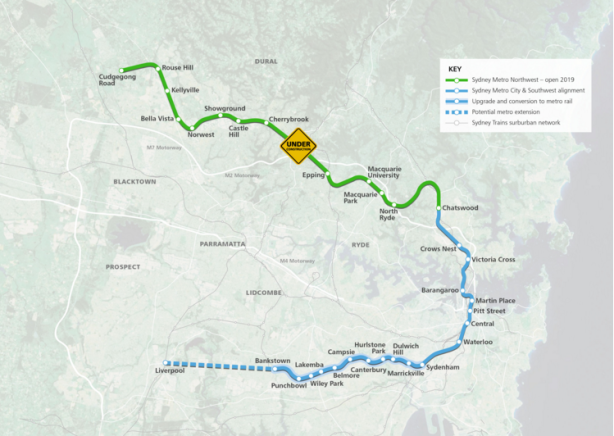
The current incarnation of this line was announced in 2010, with construction commencing in 2014. It is scheduled to open in 2019. This line consists of 23km of new track between Epping and Cudgegong Rd near Rouse Hill as well as the conversion of the existing 13km Epping to Chatswood Line (opened in 2009) to metro operation.

A line with a similar alignment was originally announced in 1998 (connecting to the Northern Line at Eastwood rather than Epping), but cancelled in 2008 in favour of a metro line that was itself also cancelled. It has previously been known as the North West Rail Link and Sydney Rapid Transit.

2015-02-20 NWRL

Alignment of the Sydney Metro Northwest from Cudgegong Rd to Chatswood. Click to enlarge. (Source: Transport for NSW.)

Under construction: Sydney Metro City and Southwest

This line was announced in 2014, with construction commencing in 2017. It is scheduled to open in 2024. This line consists of 13km of new track between Chatswood and Sydenham as well as the conversion of the existing 17km Bankstown Line between Sydenham and Bankstown to metro operation.

Sydney Metro City and Southwest Alignment 2016

Sydney Metro City and Southwest alignment. Click to enlarge. (Source: Transport for NSW.)

Announced: Sydney Metro West

This line was announced in 2016, with no date currently set for construction to commence. It is scheduled to open in the second half of the 2020s, though the government is understood to be keen to fast track a 2026 opening date. Stations have been confirmed for Parramatta, Sydney Olympic Park, the bays precinct, and the Sydney CBD.

Four options are currently being considered, with a Metro Rapid option firming as the favourite providing the highest benefit-cost ratio. This option involves a 20 minute journey between Parramatta and the Sydney CBD, with trains travelling between 10 stations at up to 130km/hour, with a benefit-cost ratio of 2.5.

UPDATE: However, the favoured option appears to be the Metro Local South. This option involves a 25 minute journey between Parramatta and the Sydney CBD, with trains travelling between 12 stations at up to 100km/hour, with a benefit-cost ratio of 2.3 when the sale of air rights to development above stations is taken into account.

2016-10-18-west-metro-and-cbd-metro-alignment

Planned route of the 2008 West Metro, which may be indicative of the future Sydney Metro West. Click to enlarge. (Source: Railway Gazette)

Announced: Leppington to St Marys extension

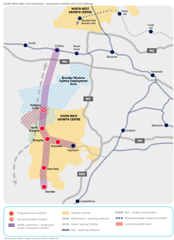
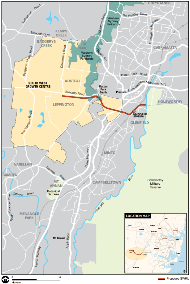
Technically not yet announced, the government is understood to be about to announce an extension of the existing T2 Line from Leppington to the T1 Line at St Marys via a new Western Sydney Airport at Badgerys Creek. Previous investigations into an extension of the South West Rail Link from Leppington also included a Southern extension to Narellan. This extension provides the greatest potential for a freight rail connection to the new airport, whereas a metro connection would be unlikely to provide the opportunity for freight trains to reach the new airport.

2014-05-04 swrl-extension-corridor-map

The proposed corridors for an extension of the SWRL through to Badgerys Creek and beyond. Click to enlarge. (Source: Transport for NSW.)

NSW Premier Gladys Berejiklian has indicated her preference is for a rail connection after the airport opens and further commented that “Some major airports around the world take up to 10 years to build a rail line”. With a 2026 scheduled opening date for a Western Sydney Airport, this would suggest a 2026-36 opening date for an airport railway.

Meanwhile, Federal Opposition Leader Bill Shorten announced his support in April 2017 for a North-South rail connection, but went further in calling for it to be completed in time for the opening of a Western Sydney Airport in 2026. So although there is a difference in opinion on timing, there is now bipartisanship support for a rail line connecting the airport to Leppington and St Marys.

Proposed: Cudgegong Rd to Marsden Park extension

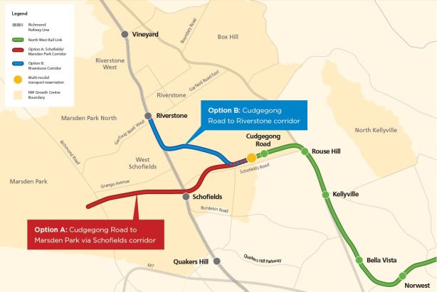
Work on preserving a corridor to extend the Sydney Metro Northwest began before construction on the line had even begun. Two options were considered: a Northern extension to Riverstone and a Western extension to Marsden Park via Schofields. The latter option was chosen with the potential to extend it further to the Mount Druitt area, although the corridor is to be reserved with mode neutrality. In other words, it could be both as an extension of Sydney Metro, but it could also be built as even bus rapid transit/light rail or even heavy rail with double deck trains from the T1 Western Line at Mount Druitt or St Marys.

NWRL Extension Corridor Options

Two options exist for linking the NWRL to the Richmond Line. One goes North West to Vineyard, the other continues west through Schofields and towards Marsden Park. Click to enlarge. (Source: http://northwestoptions.com.au)

Proposed: Bankstown to Liverpool extension

This proposal would see the Sydney Metro extended from the currently planned terminus at Bankstown out to Liverpool.

Such a line could link both Bankstown and Liverpool to Bankstown Airport, allowing for potential redevelopment of the current airport site. That would be in line with the Government´s pattern of building new transport infrastructure in places that enable new developments, including Waterloo, Sydney Olympic Park, the Bays Precinct, or the proposed redevelopment of Long Bay Prison. It would also provide connections between Liverpool and the Sydney CBD via Bankstown that are set to be lost once the Bankstown Line is converted to Metro services by 2024.

VIDEO: Sydney Metro: Future Options – Bankstown to Liverpool (Transport for NSW)

Proposed: Parramatta to Western Sydney Airport extension

A Western extension to the Sydney Metro West, this line would link up Parramatta with a Western Sydney Airport at Badgerys Creek. With the airport and metro line each scheduled to open in 2026 or later, much of

Prime Minister Malcolm Turnbull has called for a rail link to the airport to be built by the year 2046, but not necessarily ready to open simultaneously with a Western Sydney Airport. However, this was before the NSW Government opted for a North-South rail link from Leppington to St Marys, which is set to be announced jointly with the federal government.

2016-03-12 Parramatta Fast Rail Route

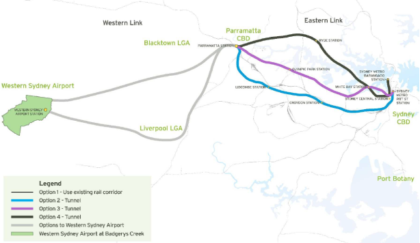
Potential alignments for a fast rail connection from Parramatta to a Western Sydney Airport at Badgeries Creek and the Sydney CBD. Click to enlarge. (Source: Parramatta City Council, Western Sydney Airport Fast Train – Discussion Paper, page 12.)

Proposed: City to Long Bay extension

An Eastern extension of the Sydney Metro West, this line would link up the Sydney CBD to the South East along a former tram reservation on Anzac Parade. To this date, there is no official government proposal for this line, only an unsolicited proposal from 2016.

However, Infrastructure NSW has been investigating the Anzac Parade corridor since 2014. The plans would involve the sale of the Long Bay Prison for redevelopment, which itself would help to fund the construction costs of a rail line down that corridor. This is in line with similar plans for Waterloo, the Bays Precinct and Sydney Olympic Park where new metro lines would support redevelopment that would in turn be enabled by the new metro line.

So far, this corridor has been investigated for an extension of the currently under construction light rail line out to Kingsford. Despite this, the close correlation between the unsolicited proposal and line actually being planned at the moment are close enough that an extension to La Perouse via Long Bay appears like a good proxy for official government policy.

A metro line connecting Sydney’s CBD to Parramatta is firming as the most likely major rail project to be completed once the currently under construction Sydney Metro opens in 2024. This follows the windfall gains received by the NSW Government in the 99 year lease of its poles and wires, with Daily Telegraph political editor Andrew Clennel citing senior government sources that the highest priority in using the proceeds of the privatisation funds will be a “third Metro line from the CBD to Parramatta — taking pressure off the above-ground rail line which is already near capacity”.

The NSW Government is currently reviewing an unsolicited proposal to build such a line, received in July of this year. The cost is estimated at $10bn and could be partly funded through value capture. This would be possible in sites like the Bays Precinct, Olympic Park, Camellia, and Badgerys Creek. However, it remains uncertain what this means for current plans for a light rail connection from Parramatta to Olympic Park, with suggestions that such a link may be shelved and replaced by a metro rail line.

2017-10-23 All Options.png

Transport for NSW subsequently published a discussion paper and is now seeking feedback until 28 October. The discussion paper outlines a number of options, split into Options A-E Western Sydney (mostly connecting Parramatta to the Sydney CBD) and Options 1-6 Western Sydney Airport (connecting the new Western Sydney Airport to the rail network).

Option A, a new western metro-style service, would appear to be the proposal being put forward by the consortium and therefore be the front runner. It is described as:

This line requires a tunnel to be built between Sydney and Parramatta / Westmead with stations located every few kilometres. It could operate as a stand-alone, metro-style, all stops service using high capacity single deck trains with the potential to transport 40,000 extra passengers per hour. It could potentially provide journey times between Sydney and Parramatta of around 30 minutes and relieve some demand on the existing network. This could also support opportunities for new developments at locations such as Olympic Park, Five Dock and The Bays precinct.

2016-10-23 Option A.png

Option 5, a direct rail express service from Western Sydney Airport to Parramatta, appears to be the proposal most similar to that being put forward by the consortium and would therefore also be the front runner. However, it involves a 160km/hour express service rather than a metro style service with frequent stops as previous Option A put forward:

This option would include a direct rail express service from the proposed Western Sydney Airport to Parramatta and through to Sydney CBD. This line would require a new tunnel as it approaches Parramatta and from Parramatta through to the Sydney CBD. This service offers the potential for the fastest service between the airport and these two major centres, but would be comparatively expensive to construct. Initial assessments indicate that such a line could achieve journey times of 15 minutes from the proposed Western Sydney Airport to Parramatta and 12 minutes from Parramatta to the Sydney CBD based on a maximum speed of 160 kilometres per hour. While such a service would provide a short travel time to the broader Sydney Basin and CBD, it would not necessarily service the population who are expected to work at and use a Western Sydney Airport in the short-term.

2016-10-23 Option 5.png

This proposal builds on a March 2016 Parramatta City Council feasability study which suggested a fast train rail link along this corridor, providing a 15 minute rail journey from Parramatta to the Sydney CBD that would also connect Parramatta to a Western Sydney Airport.

2016-03-12 Parramatta Fast Rail Route.PNG


Should such a line go ahead, it would pass though and potentially create a new economic corridor for Sydney. The existing “Global Economic Corridor” originally consisted of an zone spanning across Sydney Airport, the Sydney CBD, North Sydney, St Leonards, Chatswood, and Macquarie Park; recently also being expanded to include Norwest Business Park and Parramatta. This new economic corridor would encapsulate Western Sydney Airport, Parramatta, Olympic Park, the Bays District, and the Sydney CBD. This new corridor would pass through Sydney’s 3 cities described by Greater Sydney Commission Chair Lucy Turnbull.

Commentary: How might this line be built?

The Western rail corridor from Parramatta to the Sydney CBD remains one of the most congested in the Sydney network and yet has been seemingly neglected in terms of capacity improvements. Therefore, additional rail capacity is a welcome possibility. What is less certain is how much of it can be paid for with value capture, whether the journey times will be 15 or 30 minutes, and $10bn price tag.

A recent study focused on the Gold Coast Light Rail line found that value capture would be able to pay for only 25% of the capital costs of building the line. Using that as a benchmark suggests that governments will still be liable to fund the majority of the construction costs for major public transport projects. This is also why the windfall gains from recent privatisations is so significant: it makes a project like this possible.

The 15 minute journey time is possible, but unlikely unless the journey is express. The predicted journey times for the 2008 West Metro, which involved a 22km journey that included 10 stations, was 26 minutes. This equates roughly to 45 seconds/km (the equivalent of 80km/hour), plus an additional 1 minute/station. This also corresponds to the estimated journey times for the Sydney Metro currently under construction. So 25-30 minutes would appear a much more realistic journey time than 15 minutes.

2016-10-23 CBD to Parramatta Metro estimated costs.PNG

Finally, there is the construction costs. Here, a lot depends on how the line is constructed and a number of assumptions will be made. The 2008 West Metro is a good starting point, with the adjustment that it pass through the Bays Precinct and then most likely entering the CBD at Barangaroo. This would involve a similar number of stations, but with a slightly shorter length of perhaps 21km rather than 22km. Curiously, this would effectively see a hybrid of the West Metro and CBD Metro alignments, with the 2008 proposed alignments seen in the map below.

2016-10-18 West Metro and CBD Metro Alignment.PNG

Based on the costs of recent projects, but not taking future inflation into account, a more realistic cost could be just under $11bn for the Sydney CBD to Parramatta portion. From Parramatta to Badgerys Creek, the distance is longer at 26km, but about two thirds of this could be above ground rather than in a tunnel. Additionally, it would likely have fewer stations, probably 4 in total not counting Parramatta. So using the same assumptions, that portion of the project could come in at about $6bn.

That is approximately $17bn, approaching double the $10bn cited by the unsolicited proposal. This should come as no surprise, as unsolicited proposals are in the business of selling their case to the government and thus have an interest in underestimating the potential costs.

Finally there is the question of where to run the line through the CBD. The map accompanying the proposal submitted to the Government, published by the Sydney Morning Herald, suggests connecting the line to the future Sydney Metro at Barangaroo and then another line out from Waterloo out to the soon to be redeveloped Long Bay Prison in Sydney’s South East. This would have the benefit of funneling trains from two separate lines on each end of the central portion of this line, ensuring constant high frequency along the CBD portion of the Sydney Metro.

However, it would also place capacity constraints on the line. For example, it would prevent the Northwest line of the Sydney Metro from increasing its current 15 trains per hour during the peak if the Western line of the Sydney Metro were also to enjoy 15 trains per hour. It would be possible to extend the trains from 6 to 8 carriages, providing a 33% increase in capacity, but not the 167% increase in capacity that is currently possible.

The alternative is to build an additional rail line through the CBD. A second corridor under Sussex St has been reserved for such a future line, in addition to the Pitt St corridor that the current Sydney Metro line will use. Alternatively, the line could cross the CBD in an East-West direction, rather than the typical North-South direction that all the existing rail lines follow. This could potentially provide heavy rail access to Pyrmont or Taylor Square.

Either option would be challenging and disruptive. It would ordinarily also be expensive. But it could be transformational in a way very little else could and NSW has recently come across the billions of dollars necessary for such an endeavour.

VIDEO: Metropolitanisationing: Sydney Transport (Jack Walsh)

There are two rail lines in Sydney currently under construction or in the planning phase. The first is the Sydney Metro Northwest, announced in 2010 and set to open in 2019; it consists of 23km of new track between Epping and Cudgegong Rd near Rouse Hill as well as the conversion of the existing 13km Epping to Chatswood Line (opened in 2009) to metro operation. The second is the Sydney Metro City and Southwest, announced in 2014 and set to open in 2024; it consists of 13km of new track between Chatswood and Sydenham as well as the conversion of the existing 17km Bankstown Line between Sydenham and Bankstown to metro operation.

Although no firm plans are currently in place for expansion of the rail network beyond 2024, there are a number of rail lines that have been mentioned by state and federal Transport Ministers, Premiers, and Prime Ministers. In chronological order of their first announcement, these include an extension of the Sydney Metro from Cudgegong Rd to Marsden Park, an extension of the South West Rail Link to Badgerys Creek, an extension of the Sydney Metro from Bankstown to Liverpool, and a new fast train from Parramatta to the Sydney CBD and Badgerys Creek.

(Left out of this list are previously announced rail lines that have been raised in internal government documents or were official government policy but in either case have since been abandoned. These include the Parramatta to Epping Rail Link, a metro line to the Northern Beaches, a metro line to Hurstville, and an extension of the Eastern Suburbs Line to UNSW.)

Cudgegong Road to Marsden Park

Work on preserving a corridor to extend what was then known as the North West Rail Link, now Sydney Metro Northwest, began before construction on the line had even begun. Two options were considered: a Northern extension to Riverstone and a Western extension to Marsden Park via Schofields. The latter option was chosen with the potential to extend it further to the Mount Druitt area, although the corridor is to be reserved with mode neutrality. In other words, it could be both as an extension of Sydney Metro, but it could also be built as even bus rapid transit/light rail or even heavy rail with double deck trains from the T1 Western Line at Mount Druitt or St Marys.

NWRL Extension Corridor Options

Two options exist for linking the NWRL to the Richmond Line. One goes North West to Vineyard, the other continues west through Schofields and towards Marsden Park. Click to enlarge. (Source: http://northwestoptions.com.au)

Leppington to Badgerys Creek

The South West Rail Link would be extended from the current terminus at Leppington through to Badgerys Creek at the new Western Sydney Airport. This line would also include a potential extension North to St Marys and South to Narellan. By connecting to the existing heavy rail network, this line also provides the greatest potential for a freight rail connection to the new airport. However, it does not provide a fast nor a direct rail connection between the airport and Parramatta, the Sydney CBD, nor the existing Kingsford Smith Airport at Mascot.

The proposed corridors for an extension of the SWRL through to Badgerys Creek and beyond. Click to enlarge. (Source: Transport for NSW.)

The proposed corridors for an extension of the SWRL through to Badgerys Creek and beyond. Click to enlarge. (Source: Transport for NSW.)

This is also the only proposed new rail line that is an extension of the existing heavy rail network. All of the other 3 proposals involve extensions of the Sydney Metro network currently under construction or the creation of a new single deck fast train.

Bankstown to Liverpool

An extension of the Sydney Metro City and Southwest, set to open in 2024 between Chatswood and Bankstown via the Sydney CBD, this would see the line extended further out to Liverpool.

The proposed Southern extension of Sydney Metro would see the line extended from the currently planned terminus at Bankstown out to Liverpool. Click to enlarge. (Source: Transport for NSW.)

The proposed Southern extension of Sydney Metro would see the line extended from the currently planned terminus at Bankstown out to Liverpool. Click to enlarge. (Source: Transport for NSW.)

Such a line could link both Bankstown and Liverpool to Bankstown Airport, allowing for potential redevelopment of the current airport site into a new business park. It would also provide connections between Liverpool and the Sydney CBD via Bankstown that are set to be lost once the Bankstown Line is converted to Metro services at some point in the next 8 years.

VIDEO: Sydney Metro: Future Options – Bankstown to Liverpool (Transport for NSW)

Sydney to Parramatta

Parramatta City Council, in conjunction with the Western Sydney Business Chamber, have proposed a fast train from the Sydney CBD to Parramatta that would complete the journey in as little as 15 minutes. It also includes a Western Link between Parramatta and a future Western Sydney Airport at Badgerys Creek.

Potential alignments for a fast rail connection from Parramatta to a Western Sydney Airport at Badgeries Creek and the Sydney CBD. Click to enlarge. (Source: Parramatta City Council, Western Sydney Airport Fast Train - Discussion Paper, page 12.)

Potential alignments for a fast rail connection from Parramatta to a Western Sydney Airport at Badgeries Creek and the Sydney CBD. Click to enlarge. (Source: Parramatta City Council, Western Sydney Airport Fast Train – Discussion Paper, page 12.)

The Eastern Link has 4 potential alignments to Parramatta Station:

  1. Upgrading the existing surface rail corridor with stations at Central, Strathfield, and Lidcombe. This would not reduce travel times by more than a few minutes below the current 25 minute minimum. It would also do the least to add extra capacity.
  2. A tunnel underneath the existing rail corridor with stations at the future Sydney Metro Station in Pitt St, Croydon, and Lidcombe. This has longer journey times than Options 3 or 4 and has limited scope for value capture. However, it provides the most favourable tunneling conditions.
  3. A tunnel South of the Parramatta River with stations at the future Sydney Metro Station in Pitt St, White Bay, and Olypmic Park. This is the shortest and fastest option. It also has the best scope for value capture and most challenging tunneling conditions.
  4. A tunnel North of the Parramatta River with stations at the future Sydney Metro Station in Barangaroo, White Bay, and Ryde. This is longer than Option 3, but passes through more existing centres. It has less scope for value capture but better patronage in the medium term.

The Western Link has 2 potential alignments between Parramatta Station and Badgerys Creek:

  1. A Southern corridor with an intermediate station in Liverpool.
  2. A Northern corridor with an intermediate station in either Blacktown or near the M4/M7.

The Western Link has fewer details than the Eastern Link. Proponents are split over which section to build first, with Parramatta City Council CEO Greg Dyer supporting an Eastern Link and Parramatta MP Geoff Lee supporting a Western Link. Meanwhile, Prime Minister Malcolm Turnbull has called for a Western Link to be built earlier than 2046, but not necessarily ready to open simultaneously with a Western Sydney Airport. Sydney Morning Herald City Editor Jacob Saulwick argues that an Eastern Link is more pressing given the capacity constraints between Parramatta and the Sydney CBD, but that it would be a good stage one for when a future extension to Badgerys Creek becomes needed and built as stage two.

Open Drum – The Daily Commute

ABC Open is taking contributions on the topic of “the daily commute”. The deadline for contributions is midday Tuesday 9 June.

“Tell us about your daily commute. What are the joys and challenges? How does it impact your life or your family? Would improved public transport, affordable accommodation near workplaces or better roads help? Whatever happened to telecommuting? Do you have a survival tip or utopian vision for policy makers? Share your story and opinions in 350-700 words.”

1 May: Rail line to Badgerys Creek downplayed

Suggestions for a fast rail service between Badgerys Creek and Sydney CBD in time for the opening of a future Western Sydney Airport were dismissed by the Federal Transport Minister Warren Truss. “A rail line connected to the metropolitan area of Sydney is not essential in that [early] phase” said Mr Truss. The NSW Transport Minister Andrew Constance was more open to the idea, stating that he was “putting all things on the table”, including a possible extension of Sydney Rapid Transit out to Badgerys Creek via the existing Kingsford Smith Airport at Mascot. Proposals exist to extend the recently opened South West Rail Link to Badgerys Creek, but there are no current plans or funding to do so.

The proposed corridors for an extension of the SWRL through to Badgerys Creek and beyond. Click to enlarge. (Source: Transport for NSW.)

The proposed corridors for an extension of the SWRL through to Badgerys Creek and beyond. Click to enlarge. (Source: Transport for NSW.)

4 May: Opal-only ticket gates

New ticket gates that accept only Opal cards are to be trialed at Olympic Park Station. Existing ticket barriers that accept both Opal and paper tickets will continue to be in use.

7 May: Mousetrap to catch graffiti vandals

A new technology is being trialed which detects either spray paint or permanent marker on trains, so far leading to the arrest of 30 individuals. Known as “Mousetrap”, it uses an electronic chemical sensor which detects the vapour of both spray paint and marker pens.  Live CCTV records and provides images directly to Sydney Trains staff. Removing graffiti from the Sydney Trains network cost $34 million last financial year, up from $30 million the year before.

10 May: Epping to Chatswood Line will be disconnected for almost a year

The Epping to Chatswood Line, set to be shut down for 7 months during which it will be converted and connected to the North West Rail Link in order to create the first stage of Sydney Rapid Transit, will be disconnected from the T1 Northern and North Shore Lines prior to its shut down. A recently approved government proposal will see the line operate as a shuttle service between Epping and Chatswood for 4 months prior to this conversion, most likely in 2018.

21 May: Light rail predicted to kill someone each year

A report prepared for the government predicts that 1.14 people will be killed by the new CBD and South East Light Rail line every year on average. Between 2010 and 2014, there have been 3 fatalities involving pedestrians and buses in the Sydney CBD. The report also predicts 1 fatality every 5 years for the existing light rail line to Dulwich Hill, although no deaths have occurred on this line since it opened in 1997.

22 May: Opal card user information handed over to government agencies

57 requests for Opal card data, which include the card user’s address and travel patterns, have been granted by Transport for NSW to government agencies since December 2014. A total of 181 requests were made, with no court approval required in order for information to be handed over. By comparison, information from Queensland’s Go Card had been accessed almost 11,000 times between 2006 and 2014.

26 May: NWRL tunneling 40% complete

Tunnel boring machines on the North West Rail Link have reached Showground Station. 12km of the 30km of tunneling, representing over a third of the total length, is now complete.

26 May: Long Bay Prison sale under consideration

The Government is considering the possibility of selling off Long Bay Prison, possibly raising a estimated $400m. The sale, which would see the site redeveloped, has been linked to a possible extension of the light rail line currently under construction. The CBD and South East Light Rail is set to open in 2019, initially reaching Kingsford. However, an extension as far as La Perouse has been raised as a possibility.

Potential extensions to the CBD and South East Light Rail to Maroubra, Malabar, or La Perouse. Click to enlarge. (Source: Infrastructure NSW, State Infrastructure Strategy Update 2014, p. 40.)

Potential extensions to the CBD and South East Light Rail to Maroubra, Malabar, or La Perouse. Click to enlarge. (Source: Infrastructure NSW, State Infrastructure Strategy Update 2014, p. 40.)

26 May: Congestion will be worse after WestConnex

Internal government reports show that traffic levels on inner city roads around the planned WestConnex tunnels are predicted to be higher in 2026 than in 2011, despite the planned completion of WestConnex by 2023. A spokeswoman for the WestConnex Delivery Authority commented that “[traffic on] the inner south will improve with WestConnex as opposed to a do nothing scenario”.

28 May: Light rail construction schedule announced

VIDEO: Ten Eyewitness News Sydney – Government admits public transport system “broken” (27/5/2015)

A construction schedule for the CBD and South East Light Rail was released to the public. George St is set to see three and a half years of construction, with the new CBD and South East Light Rail set to be built between September 2015 and April 2018. The line is currently scheduled to open in early 2019, following testing of the line.

The Opposition Leader Luke Foley, who recently declared his opposition to light rail on George St, compared the project to the Berlin Wall and declared that it would lead to chaos and confusion.

https://twitter.com/Luke_FoleyNSW/status/603825119916630016

The Government released video (above) of a bus and pedestrian walking down George Street during the evening peak hour showing the pedestrian being faster than the bus. Pedestrianising George St, resulting in the replacement of cars and buses with trams, has been put forward as a way to reduce congestion for public transport users which currently exists in many parts of the city.

https://twitter.com/todisappear/status/604060994101379073

The announcement also included plans to defer construction on the Northern portion of the Castlereagh St bike path until construction on the light rail line is completed. The Roads Minister Duncan Gay had previously proposed including loading zones along portions of Castlereagh St, which would have the effect of making it a “part-time” bike path. Deferring its construction pushes back the need to make a decision on this issue. However, the existing bike path on College St is set to be converted into a bus lane. This will help to handle bus movements once George St becomes closed off to vehicles, but removes a North-South bike path in the CBD for a number of years.

28 May: mX axed

Newscorp is set to discontinue mX, its free commuter newspaper. mX is currently distributed each weekday afternoon in Sydney, Melbourne, and Brisbane; it began in each of these cities in 2001, 2005, and 2007 respectively.

29 May: Electricity privatisation passes lower house

Legislation to allow the 99 year lease of 49% of the NSW electricity distribution network has passed the NSW Legislative Assembly. It now goes to the Legislative Council, where a combination of the Liberal, National, and Christian Democratic Parties that have committed to supporting the legislation have enough votes to ensure its passage through the upper house of Parliament.

https://twitter.com/mikebairdMP/status/604043115293376512

VIDEO: Infrastructure (Last Week Tonight with John Oliver)

Sydney Rapid Transit (SRT) could reach a new airport at Badgerys Creek, possibly via the existing Kingsford Smith airport at Mascot, as part of the Southern extension of a Second Harbour Rail Crossing. The idea was floated last week by the Transport Minister Andrew Constance when he said that “I think it is a case of putting all things on the table”, in which he also called on the Australian Government to provide funding for a rail line to Badgerys Creek. The Australian Government has committed $2.9bn in funding for roads to support the airport, but no money for rail.

The proposal is currently little more than a thought bubble. But if it were to happen, what could it look like and how would it build on existing plans that are already locked in?

The current plan

The North West Rail Link (NWRL) from Rouse Hill to Epping is currently under construction. It will be connected to the Epping to Chatswood Line, set to be closed in 2018 so that it can be converted, with the new Rouse Hill to Chatswood Line opening in 2019. Construction of a Second Harbour Rail Crossing from Chatswood to Sydenham will begin in 2017, and is expected to open in 2024. This will also see the Bankstown Line converted to single deck operation between Bankstown and Sydenham, also with a 2024 opening.

SYdney Rapid Transit following the conversion of the T3 Bankstown Line. Click to enlarge. (Source: Transport for NSW, Rebuilding NSW Fact sheet 3, p1.)

SYdney Rapid Transit following the conversion of the T3 Bankstown Line. Click to enlarge. (Source: Transport for NSW, Rebuilding NSW Fact sheet 3, p1.)

There are further plans to expand the line from Sydenham to Hurstville. Earlier plans showed the line extending from Bankstown to both Lidcombe and Cabramatta, but more recent plans show the line terminating at Bankstown and not continuing further.

Sydney Rapid Transit as currently proposed. Click to enlarge. (Source: Sandy Thomas, 1855 revisisted.)

Sydney Rapid Transit as currently proposed. Click to enlarge. (Source: Sandy Thomas, 1855 revisisted.)

Past plans

A rail line from the North West to the South West via the CBD is not a new concept. This is exactly what was proposed in 2005 as part of the Metropolitan Rail Expansion Program (MREP). This would involve the extension of the Epping to Chatswood Line via the construction of the NWRL and the extension of the then East Hills Line (now T2 Airport Line) via the construction of the South West Rail Link (SWRL). Core capacity would then be increased by building a new under the Harbour and CBD rail line, plus additional tracks from Chatswood to St Leonards; Sydenham to Erskineville; and Kingsgrove to Revesby. The difference is that the MREP proposal would use double deck trains and travel via Sydenham, therefore bypassing the existing Airport Line.

Metropolitan Rail Expansion Program. Click to enlarge. (Source: Sandy Thomas, 1855 revisisted.)

Metropolitan Rail Expansion Program. Click to enlarge. (Source: Sandy Thomas, 1855 revisisted.)

A metro line out towards Sydney’s South West was also part of a leaked 2012 report, which suggested extending SRT from Wolli Creek to Revesby. This would follow the initial conversion of the T3 Bankstown Line and then later also a portion of the T4 Illawarra through to Hurstville to the new SRT system. The latter of these two conversions passes through Wolli Creek, which would allow the portion of the T2 Airport Line to also be converted. SRT could then provide all station services on these lines, with the remaining T2 and T4 trains running express from the outer suburbs.

Previously proposed metro network for Sydney, including a line out to Revesby and the Northern Beaches. Click to enlarge. (Source: Transport for NSW, CBD Rail Capacity Program Rail Futures Investigations - Engineering & Construction, p30.)

Previously proposed metro network for Sydney, including a line out to Revesby and the Northern Beaches. Click to enlarge. (Source: Transport for NSW, CBD Rail Capacity Program Rail Futures Investigations – Engineering & Construction, p30.)

However, this proposal would not actually reach either airport.

How it could work

If both airports are to be connected then the entire T2 Airport Line would need to be converted to SRT between Glenfield and Central. The resultant shift of patronage from the T2 Airport Line to SRT together with the ability for SRT to reach the T2 Airport Line directly from Central without having to travel between Wolli Creek and Sydenham, eliminates the need to convert the T4 Illawarra Line to SRT. In fact, it would make more sense to maintain all station services from Hurstville within the Sydney Trains network and instead send them into the City Circle, joining the remaining T2 Airport Line trains (which would likely revert to the previous East Hills Line name, given they would no longer travel via the airport). This lifts the current capacity constraint on the T4 Illawarra Line, which along with the T1 Western Line is Sydney’s most congested.

The T2 Airport Line currently has 4 tracks between Wolli Creek through to Revesby in the West, where it drops down to 2 tracks. The line West of Revesby would need to be quadruplicated out to Glenfield, providing 2 tracks for T2 trains and 2 tracks for SRT trains. The Northern end of Glenfield Junction may also require some upgrading to prevent any conflicting moves between T2 and SRT trains, however the Southern end is flexible enough to be able to handle the merger of Sydney Trains and SRT services. From there it is simply a matter of converting the existing SWRL to SRT, while also extending the line out to Badgerys Creek or further.

Journeys from the SWRL would be limited to all stop services on SRT, which would probably take around 60 minutes from Badgerys Creek to Central (perhaps 45 minutes if SRT allowed for shorter dwell times and faster acceleration). Passengers could change at Glenfield with a simple cross platform transfer to a faster express train directly to Central (or elsewhere).

Meanwhile, the shutdown of the T2 Airport Line for SRT conversion could also be used as an opportunity to add an additional station (Doody St) between Mascot and Green Square and/or an additional station (Waterloo) between Green Square and Central. This would allow the Central to Sydenham alignment of SRT to take the Northern approach, via Sydney University; rather than the alternative proposal via Waterloo.

The proposed Doody St Station would be located between the existing Mascot and Green Square Stations on the Airport Line. Click to enlarge. (Source: EcoTransit.)

The proposed Doody St Station would be located between the existing Mascot and Green Square Stations on the Airport Line. Click to enlarge. (Source: EcoTransit.)

The 10km portion of the T2 Airport Line between Wolli Creek and Central is currently privately owned, but reverts to public ownership in 2030. Conversion would probably have to occur after 2030. However, with the initial Rouse Hill to Bankstown portion of SRT set to open in 2024 and an airport at Badgerys Creek set to open in 2026, the timing is not too far off the mark. Rail services would not be running on the day the airport opens, but they could commence a few years afterwards. This is problematic if the aim is rail on day one, but ideal timing if the aim is for a gradual increase in transport connections as airport usage ramps up over time.

Note: Life has been busy for the last 2 months and I have not had a chance to put up any new posts. I am still alive, and after a much needed break it’s time to return. The old weekly updates will probably be replaced with monthly updates supplemented with more posts on specific topics. The aim is for 2-4 posts per month all up.

1 April: Andrew Constance replaces Gladys Berejiklian as Transport Mininster

The former Transport Minister and Deputy Liberal Party Leader, Gladys Berejiklian, received a promotion to Treasurer and will be replaced by Andrew Constance who will hold the new title of Transport and Infrastructure Minister. Duncan Gay remains Roads Minister and John Ajaka is the Parliamentary Secretary for Transport and Roads.

https://twitter.com/AndrewConstance/status/583562140776173569

7 April: Penny Sharpe may remain in Parliament

The Shadow Transport Minister, Penny Sharpe, may be reappointed to the Legislative Council seat that she recently resigned in order to contest the Legislative Assembly seat of Newtown. Ms Sharpe lost her bid to enter the Legislative Assembly and after this loss had initially planned to leave politics.

8 April: Early works begin on SRT

Over coming weeks, geotechnical drilling will occur up to 70 metres below Sydney Harbour to help determine the best location for the new Sydney Rapid Transit railway tunnels. About 30 boreholes will be drilled as part of the Sydney Rapid Transit geotechnical program, with roughly half of them beneath Sydney Harbour and the rest on land either side along the route at Sydenham, in the Sydney CBD, North Sydney, Crows Nest, and Artarmon. Construction is currently planned to begin in 2017, with a 2024 opening date.

Possible alignments and stations for the Second Harbour Rail Crossing. Click to enlarge. (Source: Transport for NSW.)

Possible alignments and stations for the Second Harbour Rail Crossing. Click to enlarge. (Source: Transport for NSW.)

16 April: Initial plans for rail line at Badgerys Creek released

Plans for the layout of a future Badgerys Creek Airport, provided to the Australian Government in February and obtained by the Daily Telegraph, show an airport rail line will run parallel to and in between the eventual 2 runways (shown as a green dashed line in the image below). The rail line is currently planned as an extension of the recently opened South West Rail Link, with a potential further extension North to the Western Line.

22 April: Heavy rains cause flooding and disruption to the rail network

Heavy rains in Sydney caused significant disruptions to the rail network, including the temporary closure of some train stations due to flooding.

NOTE: This post was meant to be written for 31 December 2014, but was delayed for numerous reasons.

Reflecting back on 2014

2015-01-05 Stats for 2014

This blog received over 255 thousand views in 2014, a time during which:

Posts with the most views

  1. Paper tickets to be retired and replaced with Opal, 1 June 2014 (7,693 views)
  2. Badgerys Creek infrastructure and noise impacts, 16 April 2014 (6,969 views)
  3. Sydney maps: real and fictional, 12 February 2014 (3,484 view)
  4. Opal’s hidden gems, 31 January 2014 (3,008 views)
  5. Metro plan could cost more and Northern Beaches Rail Line in the planning, 3 February 2014 (2,818 views)

Opal and its rollout garnered a great deal of interest, particularly given the bulk of the rollout occurred during 2014. Most the posts with high traffic were also either original content (Sydney maps: real and fictional or Opal’s hidden gems), or covered specific current issues in greater detail than other media did (Badgerys Creek infrastructure and noise impacts or Metro plan could cost more and Northern Beaches Rail Line in the planning).

11 June was the single day with the highest traffic volumes, with 1,924 views. This was the day after the Asset sales to fund Sydney Rapid Transit post was published. That post was not the most viewed post, but was likely viewed many times on the home page, rather than as a specific post.

Posts with the most comments

  1. This week in transport (7 December 2014)7 December 2014 (128 comments)
  2. This week in transport (30 March 2014)30 March 2014 (121 comments)
  3. Metro plan could cost more and Northern Beaches Rail Line in the planning, 3 February 2014 (92 comments)
  4. Commentary: Why a 2nd Harbour road tunnel is a good thing, 22 November 2014 (63 comments)
  5. Asset sale to fund Sydney Rapid Transit, 10 June 2014 (60 comments)

The 7 December post was in relation to the CBD and South East Light Rail (CSELR), while the 30 March post was in relation to the North West Rail Link. All up, Sydney Rapid Transit was responsible for igniting debate in 3 of the top 5 commented on posts, while the other two were in relation to the CSELR and a future Northern extension to WestConnex. All are projects that are still for the most part in the planning stages, with construction either yet to begin or only recently having begun.

The most frequent commenters over the last year were Simon (140 comments), Ray (123 comments), QPP (84 comments), MrV (77 comments), JC (58 comments).

Thank you to all commenters for engaging in discussion. Comments are always welcome.

Posts with the most activity on social media

  1. Paper tickets to be retired and replaced with Opal, 1 June 2014 (42 shares on Facebook and 3 tweets on Twitter)
  2. Opal soon to be available on entire Sydney Trains network19 February 2014 (41 shares on Facebook and 1 tweet on Twitter)
  3. Comparing Opal to Myki and TCard, 29 January 2014 (21 shares on Facebook and 11 tweets on Twitter)
  4. Live Blog – All Stations Challenge (22 December 2014), 22 December 2014 (18 shares on Facebook and 15 tweets on Twitter)
  5. The cost of transport and fare setting10 January 2014 (24 shares on Facebook and 2 tweets on Twitter)

Opal was, again, the issue that got readers to share posts from this blog. All up there were 2,651 referrals to this blog from Twitter and 1,971 from Facebook during the past year. Together they represent about 1.8% of all views on this blog.

Terms with the most searches

  1. Rail map (1,064 searches)
  2. Badgerys Creek airport (966 searches)
  3. WestConnex (238 searches)
  4. Sydney transport blog (191 searches)
  5. Sydney trains (184 searches)

Over 100,000 referrals came from search engines, of which approximately 95% were anonymous searches. The remaining 5% of searches were ll quite different, so similar search terms (e.g. Badgerys Creek airport, Badgerys Creek airport flight path, Badgerys Creek airport noise map, etc) with more than 5 searches were added up. Various combinations of rail maps and Badgerys Creek airport each yielded the greatest number of searches. However, it is difficult to tell if these are a representative sample of all searches.

Looking forward to 2015

The first half of this new year will see the opening of the South West Rail Link (February), the NSW State election (March), and the start of construction on the CBD portion of the CSELR after the Centenary of Anzac Day (April). Changes to the CBD bus network are also set to be announced during this time.

The new year will also see the rollout of Opal Concession cards and ticket machines plus the start of construction on the M4 and M5 portions of WestConnex. Details are also awaited on which alignment is chosen for light rail from Parramatta and specific information on enhancements to be made to Western Sydney’s heavy rail network in order to expand network capacity once the Epping to Chatswood Rail Link is closed in 2018 to be integrated into the Sydney Rapid Transit network.

Monday: Removal of paper tickets goes ahead without a major hitch

14 paper tickets, mostly long term periodicals, were no longer sold from Monday onwards, as the Opal rollout continues. Calls for customers to be patient by the Transport Minister Gladys Berejiklian turned out to be unnecessary, with the Monday morning commute lacking the feared long queues at the ticket windows or confused customers unaware of how to use their new Opal card. The day was referred to as a “big success” and compared to the Y2K bug which was also much feared in the lead up to it but caused little to no issues.

Any retired tickets obtained prior to 1 September can be continued to be used until they expire. Opal has been rolled out to all trains and ferries, with 2,800 of the states 5,000 buses Opal enabled. Opal is scheduled to be rolled out to trams in early 2015, while pensioner and student/concession Opal cards are slated for late 2014 and early 2015 respectively.

Friday: Government and Sydney Airport get heated over Badgerys Creek

Federal Assistant Infrastructure Minister Jamie Briggs has suggested that the government will find a new partner to build and operate the planned airport at Badgerys Creek. The owners of the current Kingsford-Smith Airport at Mascot has first right of refusal over an airport at Badgerys Creek, meaning that the government must make them an offer and only if that offer is refused can the government make that exact same offer to others. Max Moore Wilton, the Chairman of the Sydney Airports Corporation that owns Kingsford-Smith, subsequently suggested Mr Briggs was a “talented amateur” and that Mr Moore-Wilton would go over Mr Brigg’s head to more senior ministers.

Badgerys Creek Airport relative to Kingsford-Smith and Wilton. Click to enlarge. (Source: Author, with Google Maps)

Badgerys Creek Airport relative to Kingsford-Smith and Wilton. Click to enlarge. (Source: Author, with Google Maps)

The 2014-15 NSW Budget contains $60bn of spending on infrastructure over the next 4 years. Major projects being funded are shown below.

Major transport infrastructure projects included in the 2014-15 NSW Budget. Click to enlarge. (Sources: NSW Treasury, Transport for NSW, Open Street Map.)

Major transport infrastructure projects included in the 2014-15 NSW Budget. Click to enlarge. (Sources: NSW Treasury, Transport for NSW, Open Street Map.)

Highlights, along with the level of NSW Government funding and estimated completion dates, include:

  • $8.3bn on the North West Rail Link, to be completed in 2019.
  • $2.8bn on 65 new trains, to be completed in 2024.
  • $1.8bn on the South West Rail Link, to be completed in 2015.
  • $1.8bn on the WestConnex freeway: M4 East/M4 South/M5 East (topping up $1.5bn in Federal Government funding), to be completed in 2023.
  • $1.6bn on the CBD and South East Light Rail, to be completed in 2019.
  • $633m for roads improvements to the Northern Beaches, including kerbside Bus Rapid Transit, to be completed in 2019.
  • $600m for roads around Badgerys Creek Airport (topping up $2.9bn in Federal Government funding), to be completed in 2024.
  • $400m for light rail from Parramatta once a priority route has been identified (Parramatta to Macquarie Park shown in the map as a potential option) with no set timetable for completion.
  • $400m on the NorthConnex freeway: M1 to M2 (topping up $400m in Federal Government funding), to be completed in 2019.
  • $91m on 199 new buses to replace ageing buses and expand the fleet, announced in 2014.

Infrastructure contingent on the sale of the electricity distribution network: an under the Harbour Rail Crossing (previously cited at around $10bn) and Northern/Southern extensions to WestConnex ($1.5bn) have been omitted from this list, as has the Opal rollout ($1.5bn) and an M9 Outer Orbital freeway (uncosted).

Commentary: Is this worth it?

This budget appears to be seen as quite popular. So much so that the Sydney Morning Herald began the losers portion of its “Winners and Losers section with “There are few obvious losers in this year’s pre-election budget”. Ultimately this budget provides a way of achieving the infrastructure that Sydney desperately needs in order to sustain the additional housing construction that is required to accommodate the millions of new residents it will have by the middle of the century. Asset recycling, the sale of 49% of the electricity distribution network seems to be the only way to achieve this. However, as the Daily Telegraph’s Andrew Clennell quoted a “senior Labor MP [who said]: The poles and wires gives you 10 years, then what do you do? The sale of Sydney Water? Then what?”.

That question of how to fund infrastructure long term on an ongoing basis does not appear to have been answered yet. If it does get answered, the most likely response is higher taxes. So it that worth it? Quite possibly, though privatisation does give the state a decade or two before it needs to be answered.

Monday: SWRL extension to Badgerys Creek in the planning

Planning has begun to preserve a corridor for a new rail line to the proposed new airport at Badgerys Creek. The new corridor will extend from the currently under construction South West Rail Link at Leppington through to Bagderys Creek Airport and then North to St Marys, with another line branching South at Bringelly to Narellan.

The proposed corridors for an extension of the SWRL through to Badgerys Creek and beyond. Click to enlarge. (Source: Transport for NSW.)

The proposed corridors for an extension of the SWRL through to Badgerys Creek and beyond. Click to enlarge. (Source: Transport for NSW.)

The Transport Minister Gladys Berejiklian explained that this was more than just the airport, pointing out that This work isn’t just about servicing an airport, it’s about servicing Western Sydney communities with appropriate transport links, now and into the future”. The new line will pass right through the South West Growth Centre, which is expected to house an additional 300,000 residents in coming decades.

Consultations will run for 6 weeks from 28 April to 6 June on both the alignment and station locations. Currently there are no indicative station locations North of Badgerys Creek, despite one station in this area having been earmarked in a 2013 draft strategy.

Tuesday: NWRL brings 18 storey apartments to Kellyville

Plans for high rise residential buildings up to 18 storeys are being opposed by a local residents group, who want the project restricted to 15 storeys. The project, adjacent to the Kellyville station site that will form part of the North West Rail Link set to open in 2019, was originally proposed to have a maximum height of 25 storeys. Height reductions were achieved by converting the project from a mixed use residential/commercial/retail development into primarily a residential development. The 7,000 to 8,250 square metres of planned office space was removed entirely, the amount of retail space was reduced from 3,000 to 1,900 square metres, and the number of apartment units was cut from 746 to 660 (Source: Hills Shire Council, 29/04/2014 EGM Minutes, pp. 35, 40).

Plans for 18 storey residential apartments next to Kellyville Station on the NWRL. Click to enlarge. (Source: Hills Shire Council, 29/04/2014 EGM Minutes, p. 40.)

Plans for 18 storey residential apartments next to Kellyville Station on the NWRL. Click to enlarge. (Source: Hills Shire Council, 29/04/2014 EGM Minutes, p. 40.)

The Hills Shore Council has also designated areas around the proposed Bella Vista and Showground railways stations for high rise developments in order to house the expected 100,000 new residents expected over the next 25 years.

Wednesday: Ride sharing apps restricted to taxis and hire cars

Private drivers cannot use ride sharing apps like Uber to carry paying passengers according to a clarification by Transport for NSW. These apps can allow individuals to book a driver directly, bypassing the taxi booking companies which currently enjoy close to monopoly status in the market. A Transport for NSW spokesperson said that Under the [Passenger Transport] Act, [ride sharing] must be provided in a licensed taxi or hire car, by an appropriately accredited driver, authorised by Roads and Maritime Services (RMS)”. Any driver authorised by RMS undergoes a police check.

Thursday: Multiple incidents cause transport chaos

Sydney’s road and rail transport network saw significant disruptions after a number of incidents across the city. These included a fatal collision with a cyclist by a bus on Military Road in Neutral Bay, a car crash on the M1 on the Hawkesbury River Bridge, a 2 car crash in the Harbour Tunnel, and a power outage on the light rail line between Dulwich Hill and Lilyfield.

Thursday: School contest to name tunnel boring machines

School students from Sydney’s North West will have the opportunity to name the tunnel boring machines used to create the tunnels for the North West Rail Link. Given the long-held tradition that tunnel boring machines around the world are named after women, the theme will be “Women who have made a positive contribution to life in Sydney”. Competition entries close on May 25, and will only be accepted via the North West Rail Link project website, where there is also more detail about the competition.

Friday: ARTC listed as potential privatisation target

The Australian Rail Track Corporation (ARTC) has been listed for potential privatisation in the long term, with a predicted sale value of $500m. The ARTC is owned by the Commonwealth Government, which in turn owns and operates much of the interstate freight rail network on the East Coast of Australia. It has made a financial loss in all but one year since 2007, however these have all been primarily due to asset impairment write downs and not due to losses from ongoing operations. The ARTC has earned $200m to $300m per year in the last 3 years when measured from an operating cashflow perspective, a measure which strips out non-cash transactions such as asset impairments and depreciation (Sources: ARTC, Annual Report 2013, p. 58 and Annual Report 2011, p. 48).

Friday: Cyclists may require licenses, bike paths lead to more bike usage

Cyclists would be required to hold licences and avoid major roads under a proposal being considered by the Roads Minister Duncan Gay. Meanwhile, documents obtained by the Sydney Morning Herald show that bike paths in the Sydney CBD led to a doubling in the number of cyclists but a reduction in injuries. The documents also show that more bikes use Kent St, King St, and College St each morning peak hour than cars do. These are the 3 streets in the Sydney CBD with separated bike paths currently installed.

Sydney Strategic Cycle network, much of which is currently being planned or under construction. Click to enlarge. (Source: Transport for NSW, Sydney City Access Strategy, p. 45.)

Sydney Strategic Cycle network, much of which is currently being planned or under construction. Click to enlarge. (Source: Transport for NSW, Sydney City Access Strategy, p. 45.)

The government announced its preferred bike path network last year as part of the Sydney City Access Strategy (see image above). It involved removing the College St bike path, but adding new bike paths on Castlereagh St, Pitt St, and Liverpool St while also extending the existing bike paths on Kent St and King St.

Monday: Opal rolled out to 24 bus routes on Upper North Shore

Opal cards can now be used on 24 bus routes operating in the Kuring-gai and Hornsby region. These include all routes between 556 and 599. It can also be used on the 333 bus route between the Sydney CBD and Bondi Beach, as well as all trains and ferries. The next buses to become Opal ready are expected to be in Sydney’s Eastern Suburbs, with Opal readers to be rolled out to all buses by the end of 2014. Light rail is to become Opal ready in 2015.

Wednesday: Road upgrades and new rail line for Badgerys Creek Airport

The Prime Minister Tony Abbott announced $3.5bn in funding for roads around the proposed site of Badgery’s Creek Airport, with $2.9bn to be provided by the Commonwealth and $600m by NSW. A corridor for extending the current South West Rail Link through to the airport and then up to the Western Line will also be preserved, including a tunnel and cavity for a station under the airport runway. While the roads are mostly funded by the Commonwealth and expected to be completed in time for the airport’s opening in the middle of next decade, the rail line is not expected to be opened until after the airport is completed and will have to be funded entirely by the NSW Government.

3 major road improvements - The Northern Road, Bringelly Road, and a motorway along Elizabeth Drive - as well as a rail line from Leppington through the airport and through to the Western Line, are planned to support an airport at Badgerys Creek. Click to enlarge - the image is quite large. (Source: Department of Infrastructure and Regional Development.)

3 major road improvements – The Northern Road, Bringelly Road, and a motorway along Elizabeth Drive – as well as a rail line from Leppington through the airport and through to the Western Line, are planned to support an airport at Badgerys Creek. Click to enlarge – the image is quite large. (Source: Department of Infrastructure and Regional Development.)

Thursday: Gladys Berejiklian to stay on as Transport Minister

The Premier Barry O’Farrell’s surprise resignation on Wednesday has resulted in the Treasurer Mike Baird replacing him as Premier. The Transport Mininster Gladys Berejiklian becomes Deputy Leader of the Liberal Party, but retains the Transport portfolio. There was speculation that she may have made a run for the top job or given the Treasurer’s position.

The new Premier Mr Baird has been a strong supporter of the state’s “asset recycling” policy, where state owned assets are sold off in order to fund the construction of new assets. It is speculated that the sale of the state’s electricity poles and wires could raise as much as $30bn in proceeds that could fund infrastructure projects like the North West Rail Link, Second Harbour Crossing, and light rail from Parramatta to Macquarie Park or Castle Hill, but the outgoing Premier Mr O’Farrell had been uncomittal about taking privatisation of the poles and wires to the next state election.

Thursday: Final Waratah train delivered to Sydney

The last of the 78 Waratah trains has been delivered to Sydney, almost 3 years since the first one began carrying passengers and almost 4 years since the first test train arrived. The Waratah trains now make up almost half the Sydney Trains fleet, operating on all lines except for T4 (Eastern Suburbs and Illawarra) and T6 (Carlingford).

https://twitter.com/druey/status/456701688343044096

Friday: Randwick Council to provide $68m in funding for light rail

Randwick City Council has announced its intention to provide $68m over 5 years for the CBD and South East Light Rail project. It is also pushing for the line to be extended to Maroubra Junction, from the current terminus in Kingsford, as well as for additional new parking spaces to replace those that will be lost as part of the project. The light rail line has previously received a pledge of $220m in funding from Sydney City Council. The project is estimated to cost $1.6bn and will be completed by 2019/20.


A new airport at Badgerys Creek would be an infrastructure package for Western Sydney that was “roads first, airport second” according to the Prime Minister Tony Abbott yesterday. Today he is expected to announce with the NSW Premier Barry O’Farrell that $3.5bn would be provided to fund these roads, with 80% being paid for by the federal government and the remainder by the state government. According to the Daily Telegraph, these include:

2014-04-16 Badgerys Creek roads

No federal funding will be provided for rail infrastructure, with Mr Abbott maintaining his commitment to leave the funding of urban commuter rail exclusively to the states. However, there are also plans for an extension of the currently under construction South West Rail Link (SWRL) through to Badgerys Creek Airport, then through to the Western Line via a rail tunnel under the airport. Concerns have been raised that if this rail tunnel is not built concurrently with the airport then the cost of doing so would rise by billions of dollars.

However, although a SWRL extension has been identified as a corridor that needs to be protected, it has not actually yet been protected. Nor has a corridor from Badgerys Creek to the Western Line nor an Outer Sydney Orbital for a future M9 freeway that would link a Badgerys Creek airport both North and South.

Though identified and proposed, corridors to extend the South West Rail Link to Badgerys Creek and then North to the Western Lineand an M9 freeway providing North-South connections to the airport (both shown in purple) have not yet been protected. Only corridors shown in green have actually been protected. Click to enlarge. (Source: NSW Transport Master Plan, p. 210)

Though identified and proposed, corridors to extend the South West Rail Link to Badgerys Creek then North to the Western Line and an M9 freeway providing North-South connections to the airport (1, 4, and 10 respectively – all shown in purple) have not yet been protected. Only corridors shown in green have actually been protected. Click to enlarge. (Source: Transport for NSW, 2012 NSW Transport Master Plan, p. 210)

The decision to go with Badgerys Creek is the final nail in the coffin for Wilton as a potential airport site. Wilton was not only much further away from the Sydney CBD than Badgerys Creek, but it did not benefit from proximity to Western Sydney as Badgerys did. This is what separates Badgerys Creek from Avalon in Melbourne, to which it is often compared to. Due to the location of Melbourne’s two airports, there are few parts of the city which are closer to Avalon than the main Tullamarine Airport. However, in Sydney anywhere West of Parramatta is closer to Badgerys Creek than Kingsford-Smith at Mascot.

Badgerys Creek Airport relative to Kingsford-Smith and Wilton. Click to enlarge. (Source: Author, with Google Maps)

Badgerys Creek Airport relative to Kingsford-Smith and Wilton. Click to enlarge. (Source: Author, with Google Maps)

This proximity to urban settlement has also been posed as one of Badgerys’ main disadvantages, primarily due to aircraft noise. However, according to Bob Meyer, Planning Director with Cox Richardson Architects and Planners, the noise impact from Badgerys Creek would be significantly lower than that from Kingsford-Smith, with aircraft noise from Kingsford-Smith affecting inner city residents by a factor of 30 to 100 times as much as a Badgerys Creek Airport would affect Western Sydney residents:

“At the 2011 census, at Badgerys Creek Airport, there were 2,913 dwellings within the 20 ANEF contour and 328 dwellings within the 25 ANEF contour.
At the 2011 census, at Sydney Kingsford Smith Airport, there were 86,017 dwellings within the 20 ANEF contour and 29,457 dwellings within the 25 ANEF contour.”Bob Meyer, A Sydney West Airport, p. 5 (2013)

This is largely due to around 90% of the flight path operating over the Western Sydney Employment Area. Established residential areas are not reached for about 20km, the equivalent of Macquarie University at North Ryde for Kingsford-Smith Airport. Those 2,913 dwellings that are affected can be provided with noise insulation.

Aircraft noise from Badgerys Creek will primarily occur over industrial lands, shown in purple. The first major residential area is Greystanes, East of the Prospect Reservoir. Click to enlarge. (Source: Bob Meyer, A Sydney West Airport, p. 6)

Aircraft noise from Badgerys Creek will primarily occur over industrial lands, shown in purple. The first major residential area is Greystanes, East of the Prospect Reservoir. Click to enlarge. (Source: Bob Meyer, A Sydney West Airport, p. 6)

If the Western Sydney Employment Area were superimposed on the Kingsford-Smith Airport flight paths, then the first major residential area would be in North Ryde. Click to enlarge. (Source: Bob Meyer, A Sydney West Airport, p. 6)

If the Western Sydney Employment Area were superimposed on the Kingsford-Smith Airport flight paths, then the first major residential area would be in North Ryde. Click to enlarge. (Source: Bob Meyer, A Sydney West Airport, p. 6)

Even with new residential developments in the nearby South West Growth Centre (SWGC), the direction of flights and industrial land buffer between residential areas and the proposed airport site mean that noise concerns can be kept to a minimum. The map immediately below, created by combining the noise contour map and SWGC, shows the high noise contour lines passing through industrial lands, Kemps Creek, the Western Sydney Parklands, and Austral. Though Kemps Creek and Austral were initially zoned entirely residential, they have since been re-zoned so that areas of it which were to be affected by aircraft noise are now also industrial (see final image).

Aircraft noise from Badgerys Creek and the South West Growth Centre. Most areas affected by high noise levels are industrial. Click to enalrge. (Source: Cammo2004 using Infrastructure Australia and NSW Department of Planning.)

Aircraft noise from Badgerys Creek and the South West Growth Centre. Most areas affected by high noise levels are industrial. Click to enalrge. (Source: Cammo2004, using Infrastructure Australia, p. 333, and NSW Department of Planning.)

Northern parts of the South West Growth Centre affected by aircraft noise that werte initially zoned residential have now been rezoned industrial. Click to enlarge. (Source: NSW Department of Planning)

Northern parts of the South West Growth Centre affected by aircraft noise that werte initially zoned residential have now been rezoned industrial. Click to enlarge. (Source: NSW Department of Planning)


Monday: Federal government to pay billions in infrastructure for Badgerys Creek Airport
Billions of dollars are to be provided by the federal government for improved infrastructure for a soon to be proposed airport at Badgerys Creek. This is an increase on the initial $200m rumoured to be provided, but controversially none will be used to fund improvements to the rail network. The federal government has a policy of not funding urban rail projects, on the basis that this is a state government responsibility.

Tuesday: New Opal cards coming
Opal cards are now available for children and, for the first time, can be obtained in person at the Easter Show. Until now, the only Opal cards available were for adults and had to be obtained via the Opal website.  (TfNSW). The child Opal cards require all children to pay a separate fare, whereas currently only 1 child ticket is required for children travelling with an adult, regardless of how many children are travelling.

Child Opal cards are now available. Click to enlarge. (Source: Transport for NSW)

Child Opal cards are now available. Click to enlarge. (Source: Transport for NSW)

Pensioners will get their own Opal cards later this year, with a $2.50 daily cap on fares. However, unlike the existing Pensioner Excursion Ticket, they will not be able to be purchased from bus drivers. No details are available on when concession Opal cards for students above 16 years of age will be rolled out.

Friday: Opal rollout moves from trains to buses
Opal cards are now valid for travel to and from all train stations, on both the Sydney Trains and NSW TrainLink networks. From Monday, it will be extended to buses from the Transdev-operated Mount Kuring-gai bus depot covering bus services 556 to 599. It is currently only available on 594/594H and 333 bus routes.

Opal cards will be accepted on more buses on the North Shore from Monday 14 April. Click to enlarge. (Source: Transport for NSW)

Opal cards will be accepted on more buses on the North Shore from Monday 14 April. Click to enlarge. (Source: Transport for NSW)

Friday: Double deck trains have higher capacity than single deck trains
The ABC’s fact checking unit has declared that double deck trains have a higher capacity than single deck trains, even after taking into account the fact that single deck trains allow more trains per hour than double deck trains do. This follows claims by the NSW Premier Barry O’Farrell that it was a mistake to introduce double deck trains into Sydney and that single deck trains can carry more people per hour than double deck trains can.

Saturday: Bus depots considered for development
Bus depots at Waverly and Neutral Bay were rumoured to be considered for sale to developers for urban development. Both sites are large and close to the major centres of Bondi Junction and North Sydney. It is unclear whether the sites would be sold off entirely, or just the air rights over the depot, maintaining a functioning depot in place.

Monday: NWRL months ahead of schedule, O’Farrell calls double deck trains a mistake

The tunnel boring machines for the North West Rail Link (NWRL) will be in the ground by October, 2 months ahead of the original “end of 2014” deadline. The NSW Government had previously committed to begin construction of the NWRL in its first term of government, which places a deadline of the March 2015 state election.

The tunnels for the new line will be too steep and too narrow for the existing double deck rolling stock to run on, a controversial decision that will save $200m in constructions costs. Opponents have linked this move to the 1855 decision that resulted in different 3 different rail gauges being used in different parts of Australia as it will create completely independent sectors of the rail network. NSW Premier Barry O’Farrell countered by saying that “one of the decisions I think state governments got wrong decades ago was to move to double-decks, instead of matching what’s happening in Paris, in London, where single-deck were retained”, adding that single deck trains “can carry more people, travel more quickly, and disembark those people more quickly without people having to come down those difficult steps that exist on our double-decks and that delay people at railway stations”.

https://twitter.com/jetpack/status/447872518842380288

Wednesday: Opal to rollout to entire rail network by April

The Opal electronic ticketing system was rolled out the remainder of the Sydney Trains network on Friday 28 March, with 150,000 Opal cards now registered for use. It is currently scheduled to be rolled out to all NSW TrainLink stations progressively on 4 April and 11 April, which will complete the rollout to ferries and trains. The rollout will then move on to buses, which are scheduled to have Opal readers installed by the end of 2014, and light rail, which are currently scheduled to have Opal readers installed by 2015.

An adult Opal smartcard. Click to enlarge. (Source: Transport for NSW)

An adult Opal smartcard. Click to enlarge.
(Source: Transport for NSW.)

The lack of Opal readers or poles to hold readers installed at the new light rail stations suggests that readers will be instead installed directly inside the trams themselves. However, given that the current fleet of trams is being replaced, and that the new trams are not expected to arrive until early 2015, this further suggests that the light rail rollout is unlikely to be completed earlier than 2015 unless the new trams arrive earlier than is currently scheduled.

Thursday: Federal Government links Medibank Private sale to Badgerys Creek infrastructure

The $4bn expected to be raised from the sale of Medibank Private could go towards funding infrastructure, particularly infrastructure required for a Second Sydney Airport at Badgerys Creek. Federal Treasurer Joe Hockey has encouraged states to follow this policy of “asset recycling”, where state owned assets are sold off in order to fund the construction of additional assets in the form of infrastructure. The NSW Government has done this, with part of the proceeds of the sale of Port Botany funding the initial stage of WestConnex.

 Thursday: Inner West Light Rail extension to Dulwich Hill opens

The 5.6km extension to Sydney’s sole light rail line opened on Friday 28 March, with trams now running between Dulwich Hill and Lilyfield before continuing on to Central Station via Pyrmont. EcoTransit co-convenor Gavin Gatenby wrote on the history of how the line came to be a reality, while Lachlan Drummond wrote a review of the line itself after riding one of the new trams from Dulwich Hill into Chinatown and back.

https://twitter.com/jetpack/status/448942872050401280

Friday: Transurban buys Cross City Tunnel for $475m

Toll road operator Transurban has acquired Sydney’s Cross City Tunnel (CCT), solidifying its ownership of toll roads in Sydney. The CCT had been in voluntary administration since September 2013 for the second time since opening in 2005. It first went into receivership in 2007 and was bought by the Royal Bank of Scotland for $700m, much less than the original construction cost of $1bn. Shortly after returning to receivership in September 2013, the senior debt of the CCT was acquired by Transurban in November 2013 for $475m, effectively making Transurban the new owners of the toll road. Transurban owns a large number of other toll roads in Sydney, including the M2, M7, M5, and Eastern Distributor, as well as the currently under construction M1 to M2 tunnel (formerly known as F3 to M2). Analysts predict that this will allow Transurban to operate the CCT with lower maintenance and operational costs than the previous operators.


Monday: Town Hall Station gets an upgrade

Town Hall Station is to be the first of 19 stations across the network to get a major $8m facelift with new tiles, better lighting, and upgraded staircases. It forms part of a $20m “refresh” program for stations across the network including Parramatta, Bondi Junction, St Leonards, and Hurstville.

Artists impression of the upgrades for Town Hall Station. Click to enlarge. (Source: Transport for NSW.)

Artists impression of the upgrades for Town Hall Station. Click to enlarge. (Source: Transport for NSW.)

Wednesday: Badgery’s Creek airport needs an express rail line

Peter Thornton, one of the authors of the report calling for an airport at Badgery’s Creek, has called for express trains to run on any future rail line out to a potential airport on the site. Mr Thornton argues that running all stop services would cause unacceptably long journey times for passengers travelling from Badgery’s Creek to either Kingsford Smith Airport or the Sydney CBD, both of which could potentially be on the same line that links up to Badgery’s Creek.

It has been previously pointed out that building a rail line after the airport is complete would require billions of additional dollars in tunnelling costs, compared to the much cheaper option of cut and cover before any runways are built.

Thursday: Opal rollout to Sydney Trains as well as Southern Highlands and South Coast Lines

The Opal smartcard will be rolled out to the entire Sydney Trains network on Friday 28 March. This will be followed a week later with the South Coast Line down to both Port Kembla and Bombaderry as well as the Southern Highlands Line down to Goulbourn coming online on Friday 4 April.

This leaves the Blue Mountains and Hunter regions as the only two that will still not be Opal enabled. Opal readers have been installed at some, but not all stations in these two remaining regions. The Opal rollout will likely move on to complete the bus rollout, which so far includes only the 594/594H and 333 bus routes.

Friday: Inner West Light Rail extension to open

Sydney’s sole light rail line is set to double in length. Currently operating between Central Station and Lilifield, from Thursday 27 March it will be extended out to Dulwich Hill. The line will also feature four new look red trams, which will soon be the sole vehicle type running on the line. Frequencies will also be improved, with trams running every 10 minutes between 7AM-10AM and 3PM-6PM, with 15 minute frequencies at other times. Opal cards are not expected to be rolled out to trams until 2015.

Sydney's light rail will be extended to Dulwich Hill and feature new trams in red livery. Click to enlarge. (Source: Transport for NSW.)

Sydney’s light rail will be extended to Dulwich Hill and feature new trams in red livery. Click to enlarge. (Source: Transport for NSW.)

Hits

Happy New Year. 2013 has been an eventful one. This blog received almost 138 thousand hits during a year in which:

In the coming year, we can look forward to the opening of the Inner West Light Rail extension to Dulwich Hill and the completion of the Opal rollout (currently scheduled for the end of 2014). Meanwhile, expect the major parties to begin to announce their transport plans ahead of the next state election in early 2015, with things like a Second Harbour rail crossing, a Western Sydney light rail network, Bus Rapid Transit for the Northern Beaches, and potentially plans to privatise the state owned electricity transmission network as a means to pay for all the much needed infrastructure all likely to feature prominently.

But until then, here are some of the major events and stories from the past year, as posted, shared and commented about on this blog —

Posts with the most hits

  1. Draft 2013 timetable (part 1): Introduction 20 May 2013 (7,959 hits)
  2. 2013 timetable re-write (part 3): Untangling the network 22 February 2013 (4,844 hits)
  3. What the 2013 timetable might look like 13 May 2013 (3,908 hits)
  4. Draft 2013 timetable (part 2): AM Peak 22 May 2013 (1,430 hits)
  5. WestConnex plan finalised 19 September 2013 (1,296)

The new timetable drove a lot of traffic to this blog over the previous year, particularly when a draft of the timetable was leaked in May.

Posts with the most comments

  1. 17km Macquarie Park light rail proposed by Parramatta Council 30 August 2013 (50 comments)
  2. How might the NWRL work? 16 October 2013 (49 comments)
  3. Should the North West Rail Link be a metro? 8 February 2013 (47 comments)
  4. How might the CBD and SE Light Rail work? 9 October 2013 (46 comments)
  5. North West Rail Link – policy or politics? 11 June 2013 (43 comments)

The clear thing in common here is the North West Rail Link (NWRL), which tends to generate a lot of discussion back and forth in the comments section. The post on the Macquarie Park light rail was the most commented on post and not actually about the NWRL, but the comments soon shifted towards discussing the NWRL.

Posts with the most activity on social media

  1. All Day Challenge (October 2013), 1 October 2013 (89 shares on Facebook and 3 tweets on Twitter)
  2. Draft 2013 timetable (part 2): AM Peak 22 May 2013 (43 shares on Facebook and 8 tweets on Twitter)
  3. The worst sort of NIMBY 25 September 2013 (27 shares on Facebook and 6 tweets on Twitter)
  4. Opal running 4 months ahead of schedule 28 August 2013 (31 shares on Facebook 2 tweets on Twitter)
  5. Western Sydney makes its case for an airport of its own 15 February 2013 (11 shares on Facebook and 9 tweets on Twitter)

This probably understates the level of sharing over Twitter as tweets are only counted once, regardless of how many times that one tweet may be re-tweeted, whereas Facebook shares are each counted uniquely. That said, the most shared posts have tended to be driven by shares on Facebook rather than tweets on Twitter.

Most searched terms

  1. westconnex (635 searches)
  2. cityrail map (323 searches)
  3. westconnex map (257 searches)
  4. transport sydney (170 searches)
  5. sydney train map (170 searches)

WestConnex was by far the biggest generator of hits from web searches, with the home page being the destination rather than the post itself (preventing those posts about WestConnex from ranking higher) and reflects the fact that the car remains the primary mode of transport for Sydney residents. This is in contrast to activity in the comments section and social media, both of which are more likely to be transport enthusiasts, neither of which had WestConnex in their respective top 5 for the year.

This does perhaps provide a reminder to some advocates of public transport (the writer of this blog included) that there remains some disconnect between them and the regular person on the street when it comes to enthusiasm for public transport and dislike of cars or roads.

A merry Christmas to all the readers. Here’s hoping Santa was kind to you this year. This blog’s author, historically a Westie – though residing in Sydney’s Eastern suburbs these days, received a Western Sydney Wanderer’s jersey.

WSW

Western Sydney also received some good news right before Christmas in the form of support for an airport at Badgery’s Creek from Liverpool Council, which includes the Badgery’s Creek area. It’s clear that the debate over an airport has moved on from whether one should be built, and is now over how best to build one so that Western Sydney receives the maximum benefit.

Today’s post is about engineering solutions for efficient movement of people in the form of 2 videos.

The first is in Spanish with English subtitles from Santiago, Chile (taken from the great transport blog Human Transit). It explains how a gate in the middle of a platform ensures that passengers enter the train carriage at the right spot, rather than trying to jockey for a good position when leaving the carriage onto the platform. While this gate appears irrational from the perspective of the individual, it makes the movement of people more efficient overall, even to the benefit of those who might appear to be worse off as a result.

In Sydney, the marshal’s trialled at Town Hall appear to mimic this sort of idea. While the North West Rail Link could initially see overcrowding at Chatswood as large numbers of passengers transfer from one train to another until such a time as a second Harbour Crossing is completed. Both scenarios could learn something from this low-tech engineering solution.

The second video looks at how intersections in the Netherlands are designed to allow bikes and cars to cross safely. The simplicity of the solution is breathtaking. Even more impressive is the way it allows right hand turns to be executed safely and easily (in the video they are left hand turns, due to the Dutch driving on the opposite side of the road to Australians).

With the accelerated expansion of bike paths in Sydney, this is also somewhere that city planners in Sydney could learn a thing or two from overseas.

The opening of the South West Rail Link (SWRL) connecting Leppington to Glenfield will result in the biggest change to the Sydney Trains timetable since the just implemented 2013 timetable came into effect in October (all figures below are based on this newly introduced timetable). The major question over how it will be integrated into the network revolves around the need for rolling stock.

The government has recently passed up the opportunity to increase its fleet of Waratah trains by an additional 8 to 12 above the currently planned 78 trains. These additional trains would allow the network to operate entirely with air conditioned trains, and without them it will instead have to operate some of the older S-Set trains (which are currently being phased out for lacking air conditioning). The government is retaining about 24 of the S-Set trains for this.

The non-air conditioned trains may not necessarily operate on the SWRL, and which ever line they do end up on will probably only use them during peak hour when the need for trains is at its highest.

Map of the SWRL. Click to enlarge. (Source: Glenfield Transport Interchange Review of Environmental Factors, page 2)

Map of the SWRL. Click to enlarge. (Source: Glenfield Transport Interchange Review of Environmental Factors, page 2)

The amount of rolling stock requires will depend on which line the SWRL will be connected to. One option involves running the SWRL via the East Hills and Airport Line. In the morning peak there are currently 2 East Hills Line trains per hour starting from East Hills, running limited stops to the CBD via the Airport, which could be doubled to 4 and then extended to Glenfield to link up to the SWRL. This has the advantage of being fast (42 minutes from Glenfield to Central), being relatively uncrowded (the East Hills and Airport Line could have approximately 109 passengers per 100 seats after the October 2013 timetable is implemented), and having spare capacity for adding 2 more trains per hour – which would reduce this overcrowding. However, this would require additional rolling stock, both through the doubling of existing peak hour services from East Hills from 2 to 4 trains per hour and their extension to Glenfield (where the SWRL begins).

The alternative is for the SWRL to operate as an extension of the South Line. During the morning peak hour there are currently 4 South Line trains per hour starting from Glenfield, running limited stops to the CBD via Granville. This has the advantage of not needing to add additional services or extend them, as 4 trains per hour already start at Glenfield. However, this route would result in a much longer journey (61 minutes from Glenfield to Central), is relatively crowded (the South Line could have approximately 114 passengers per 100 seats after the October 2013 timetable is implemented), and has no spare capacity for running additional trains without altering the way in which South Line and Inner West Line trains operate. This is because South Line trains run express from Strathfield while Inner West Line trains run all stops, but the lack of overtaking tracks reduces the maximum hourly capacity from 20 trains per hour down to 12.

Once the Bankstown Line is linked up to a Second Harbour Crossing and its trains removed from the City Circle, an additional 4 trains per hour can be added to the East Hills Line during the AM peak. However, the South Line will retain the same constraints previously mentioned. Additionally, should an airport ever be built at Badgerys Creek then an extension of the SWRL and East Hills Line could connect the new airport to Kingsford-Smith Airport with a continuous rail line.

Despite this, in both cases it would be possible to run all SWRL trains via the South Line and still maintain a quick and easy cross platform transfer at Glenfield. By sending all South and Cumberland Line trains through the SWRL, it would also allow independent operation of the lines to Leppington and Macarthur from Glenfield. This would prevent delays on one section of the line from immediately flowing on to the other section. This “sectorisation”, as it is known, would be even more pronounced once single deck metro trains run on the Bankstown Line and it is truncated to Cabramatta.

The SWRL currently under construction, passing underneath the Hume Highway. Click to enlarge. (Source: Transport for NSW)

The SWRL currently under construction, passing underneath the Hume Highway. Click to enlarge. (Source: Transport for NSW)

A similar challenge exists during the off-peak. Here are 3 possible options:

  1. The South Line currently operates at half hour frequencies, and these 2 trains an hour can be re-routed to the SWRL. This removes two services per hour from Campbelltown, albeit trains so slow that passengers can reach the CBD faster by waiting for the next East Hills train and catching that instead.
  2. Two trains an hour on the East Hills Line (one each starting from/terminating at Kingsgrove and Campbelltown) could each be re-routed to the SWRL. This removes one service per hour from Campbelltown, bringing it back down to half hourly services all day. Though some clever timetabling of the Cumberland Line could allow passengers South of Glenfield a quick transfer at Glenfield for a fast SWRL train into the CBD, reducing the 30 minute wait between trains.
  3. The Cumberland Line is re-routed to the SWRL. This removed a direct link to Parramatta for anyone South of Glenfield and a direct link to the CBD for anyone on the SWRL. This makes it an unlikely choice, if passengers are required to make transfers then it should be for those with non-CBD destinations.

The SWRL was recently announced to be running 12 months ahead of schedule and $100m under budget. However, the revised mid-2015 completion date is still 3 years behind the initial 2012 completion date, with the revised $2.0bn budget well above the $688m it was originally expected to cost (Source: Daily Telegraph).

If this blog were voting on September 7 purely on transport issues, and had to make a choice between one of the 2 parties that will form government, then it would with reservations cast its vote for the ALP.

There are many other issues to be considered in this election, and many details as far as just transport is considered. But broadly speaking, for the upcoming election the Coalition has promised to the NSW Government more funding for transport infrastructure (albeit only for roads, not public transport) with fewer strings attached than the ALP have, while the ALP is both prepared to fund public transport and has made a slightly more solid commitment to building a much needed airport at Badgerys Creek.

Funding Commitments

Each of the major parties have made large commitments towards 3 transport infrastructure projects, all roads: the Pacific Highway upgrade on the NSW North Coast, the M2 to F3 Link in Northern Sydney, and the WestConnex freeway in Western Sydney.

The ALP has proposed 50:50 funding, shared with the NSW Government, for the Pacific Highway, which works out to $3.5bn. If the NSW Government does not match this amount then the deal is off, and there is some uncertainty over whether the NSW Government will match this amount. The Coalition has offered an 80:20 split, or $5.6bn, with the extra $2.1bn being the Parramatta to Epping Rail Link funding the ALP has previously promised (but since dropped). It is likely that the NSW Government is holding out for a possible Coalition win on September 7 before it tries to find funding for the ALP offer, but there is no guarantee that it will. If it does, then it is likely that some or most of this money will come from other parts of the transport infrastructure budget, including public transport as NSW Transport Minister Gladys Berejiklian alluded to in her bizarre comments that she welcomed news of not receiving any funding for public transport.

The M2 to F3 project is set to receive $400m of Commonwealth funding regardless of who wins next month, following a commitment by the ALP in May which was matched by the Coalition.

Map of the proposed WestConnex alignment showing it connecting to the City West Link. (Source: WestConnex – Sydney’s next motorway priority, Infrastructure NSW, p. 17)

Map of the proposed WestConnex alignment showing it connecting to the City West Link. Click to enlarge. (Source: WestConnex – Sydney’s next motorway priority, Infrastructure NSW, p. 17)

For WestConnex, the ALP is offering to match the NSW Government’s current $1.8bn contribution, while the Coalition has promised $1.5bn. Both parties have made their funding conditional on the M4 East being extended to the CBD (a poor decision, as explained here), while Labor has also required a link to Port Botany and for existing portions of freeway to remain toll free. These requirements will result in a higher construction cost and a lower cost recovery, to the point where the total cost to the NSW Government could be lower if it rejected the extra funding. While the Coalition’s offer does have fewer strings attached, both parties are guilty of this.

Overall, a Coalition Government in Canberra would likely provide more funding ($7.5bn vs $5.7bn), and do so with fewer restrictions.

Funding philosophy

Tony Abbott has consistently voiced his view that the Commonwealth Government should not fund any urban rail projects. He has been given many opportunities to elaborate on this view, and each time he has stuck to his guns on it. Often, this has been based on false assumptions. For example, he initially argued that the Commonwealth had no history of funding urban rail (which was incorrect). He then clarified by arguing that no Commonwealth Government before current Labor Government won office in 2007 had a history of funding urban rail (which was also incorrect). Melbourne based transport advocate put it best when he said perhaps the Federal Coalition has no history of funding urban rail, but the Commonwealth most certainly does.

The ALP, on the other hand, both supports the funding of public transport and has a history of doing so. While there are no current pieces of public transport infrastructure that the ALP is offering to provide funding for, such support may be essential for projects currently in the pipeline, such as the South East Light Rail or a Second Harbour Crossing.

Route of the George Street and South East Light Rail Line. Click to enlarge. (Source: Transport for NSW)

Route of the George Street and South East Light Rail Line. Click to enlarge. (Source: Transport for NSW)

Most importantly, public transport projects are much less able to obtain private sources of funding, whereas roads are able to source all (or atleast most) of their funding from user tolls. Therefore, it is the height of ridiculousness for a Commonwealth Government, the level of government with most access to revenue raising, to rule out funding the sort of infrastructure that most needs government support to go ahead and to instead focus its funding on those projects which least need it. This is particularly the case when it’s considered that rail has a capacity 10 times as large as the equivalent amount of road space used by cars.

On the issue of funding philosophy, the ALP comes out ahead.

Second Sydney airport

Neither party is yet willing to come out and state the obvious: that Western Sydney needs an airport of its own, and that Badgerys Creek is the best site for it. Even Max Moore-Wilton, head of Sydney Airport, agrees that Sydney will need a second airport and that Badgerys is the best location. The only thing he disagrees on is the timing, claiming that Sydney Airport will have sufficient capacity until 2045.

Current and proposed Sydney airports. Click to enlarge. (Source: Google Maps, modified by author)

Current and proposed Sydney airports. Click to enlarge. (Source: Google Maps, modified by author)

But none of this can allow politicians to ignore the fact that an airport in Badgerys Creek is an essential piece of infrastructure that will allow the much needed creation of jobs in Western Sydney, which will soon overtake Sydney’s Eastern half in population. Despite this, 200,000 Western Sydney residents currently commute into Eastern Sydney each day due to a jobs deficit, and this will only increase in coming decades if nothing is done about it. This in turn puts additional stress on transport infrastructure, which in turn has resulted in pressure to build projects such as WestConnex. Improvements to Kingsford-Smith Airport at Mascot will do nothing to ease this strain on jobs and infrastructure.

Transport Minister Anthony Albanese has now declared that if re-elected, he would like to see Labor Government will begin work on a second airport in its next term, but without nominating a site. Meanwhile, the Coalition has refused to nominate a site or a start date, though at the leader’s debate this past Sunday Opposition Leader Tony Abbott did promise to make a decision in his next term. Neither of these positions is ideal, although privately it looks like both parties plan to begin work soon on an airport and choose Badgerys Creek as the location. Despite this, the ALP’s commitment is slightly more concrete than the Coalition’s and Mr Albanese is a stronger advocate for Badgerys Creek than Warren Truss as Transport Minister is likely to be.